- Home
- :
- All Communities
- :
- Products
- :
- Mapping
- :
- Map Advice Community Questions
- :
- Sharing Map Issues
- Subscribe to RSS Feed
- Mark Topic as New
- Mark Topic as Read
- Float this Topic for Current User
- Bookmark
- Subscribe
- Mute
- Printer Friendly Page
Sharing Map Issues
- Mark as New
- Bookmark
- Subscribe
- Mute
- Subscribe to RSS Feed
- Permalink
I created a map that I want to share but I get this message (attached) to Update sharing. Not sure how to get pass this so I can share my map. Help please!
- Mark as New
- Bookmark
- Subscribe
- Mute
- Subscribe to RSS Feed
- Permalink
Robin DiSalvo, when you sharing a map the content such as any feature service or layers in the web map would be required to share as well. If not when the user tries to access the map they will be required to log in and will only be able to access if the layer/s is shared with them.
I would recommend that you verify if the layer that is added to the map is shared with the same level as what you would like to share your map.
Hope that helps.
Cheers,
Manish
Manish
- Mark as New
- Bookmark
- Subscribe
- Mute
- Subscribe to RSS Feed
- Permalink
I am fairly new to ArcGIS Online and would not know how to verify a layer that came from Living Atlas. I've used this zip code layer for a couple of different maps and each time it will not allow my audience to see it unless they login. There has to be something wrong with layer below. Can you please check it out for me?
United States ZIP Code Boundaries 2018 (from Living Atlas)
- Mark as New
- Bookmark
- Subscribe
- Mute
- Subscribe to RSS Feed
- Permalink
That is Subscriber content.

It looks like what you need is provided in the item's notes:
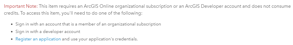
Pointing to here: Implementing App Login | ArcGIS for Developers
That will allow any user to access the subscriber content on your behalf.
- Mark as New
- Bookmark
- Subscribe
- Mute
- Subscribe to RSS Feed
- Permalink
I agree with Kory this is Subscriber content and will require login with an organizational account or you can register to use a login and share it with your users.
You can always find more information in the item details which will state any such restrictions or requirements for access.
Always a good practice to check any dependencies for the underlying data.
Hope you get it working.
Cheers,
Manish
Manish
- Mark as New
- Bookmark
- Subscribe
- Mute
- Subscribe to RSS Feed
- Permalink
That's different. I did not have to do all these steps using these two layers from the Living Atlas:
Why is this Zip Code layer so difficult to use. Is there another USA ZIP Code layer I can use without going through all these steps?
- Mark as New
- Bookmark
- Subscribe
- Mute
- Subscribe to RSS Feed
- Permalink
Robin DiSalvo, the layers are shared via Living Atlas but they are not subscriber content, hence you can access them in your application and the users can access without the need for login.
Much of the content found in the Living Atlas is available publicly, with no restrictions. Other content is not publicly available by default, and falls into two categories:
Subscriber content is the collection of layers published by Esri that requires an organizational subscription account to access. Subscriber content is provided as part of your organizational subscription and does not consume any credits.
Premium content is a type of subscriber content. It’s the collection of layers published by Esri that requires an organizational account to access, and also consumes credits. These are layers such as demographic and lifestyle layers.
Just did a quick search and found this data you can download as shapefile and publish in your ArcGIS Online or ArcGIS Enterprise and make the layer available to your users.
Hope this helps.
Cheers,
Manish
Manish