- Home
- :
- All Communities
- :
- Industries
- :
- Imagery and Remote Sensing (I&RS)
- :
- I&RS Questions
- :
- Lidar Data Processing, (Diagonal gray lines across...
- Subscribe to RSS Feed
- Mark Topic as New
- Mark Topic as Read
- Float this Topic for Current User
- Bookmark
- Subscribe
- Mute
- Printer Friendly Page
Lidar Data Processing, (Diagonal gray lines across extent for some of downloaded Lidar data)
- Mark as New
- Bookmark
- Subscribe
- Mute
- Subscribe to RSS Feed
- Permalink
Greetings,
I am having issues with some Lidar data I am trying to process to create elevation surfaces from. I downloaded the data online, and used Martin Isenburg's LasZip software, (which decompresses the Lidar data from a .laz to .las format). Next I created a new .LAS dataset in ArcMap, and added the newly decompressed .LAS files as well as calculated the statistics, (in order to filter ground, buildings, different features, etc..)
Everything was fine and I had gotten most of it processed, when I saved my MXD the other day. I went to re-open it today and across some of the tiles had diagonal gray lines running through them. This happened to me one other time, but just with a few tiles so it was an easy fix and replace. Now it appears to have happened to half of my data, and I cannot figure out why. I attached images to attempt to clarify further what I am talking about. The new .LAS dataset created in ArcMap is stored in a folder, when the data was first brought into ArcMap and for the past couple of days while working on it everything was fine. Has anyone had this issue before, or have any idea what to do here?
(On the, "Lidar_Issue_1", photo attached you can see the parallel tile has multi point return data on it, while the other tile next door has diagonal gray lines and no Lidar data on it, but did a few days ago. The second attached image has a wider extent showing multiple tiles with same issue.)
No files have been deleted, changed, etc. on my end to cause this, really unsure why this is happening..
Any help appreciated, Thank you.
Solved! Go to Solution.
Accepted Solutions
- Mark as New
- Bookmark
- Subscribe
- Mute
- Subscribe to RSS Feed
- Permalink
(Carol/Others I apologize for not responding immediately as well as not taking the advice given, I was rather frustrated with not being able to solve my issue.)
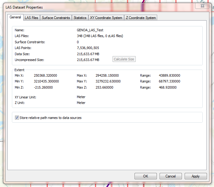
I figured out what the problem was, when creating the new LAS data set I failed to check the box below, ("Store relative path names to data sources"), despite the data being saved in the same location at the moment of my issue. I am pretty confident this was my issue, as the data seems to be pulling in correctly now. Still as seen earlier in my response, from the LAS tools support team and Isenburg himself there was talk about the diagonal gray lines being disturbance/artifacts that LAS tools throws in to protect the licensing of the software - I am unsure if this same thing happens in that case or not?
If anyone has an example of, "Artifacts", or a disturbance caused by LAS tools to protect the licensing would you mind posting about it? I am genuinely interested now and still have some unanswered questions regarding what I experienced.
Thank you all for the help!
- Mark as New
- Bookmark
- Subscribe
- Mute
- Subscribe to RSS Feed
- Permalink
I believe I realized/solved my own issue. Apparently when using Martin Isenburg's LAS tools, there is something in there that will essentially, "corrupt", your processed data so you purchase the full version of the LAS tools. I thought it was all free and open source, but apparently not regarding some research I happened upon.
Please correct me, comment still with any help or if my statement may be untrue. But I believe I found the source of my issue.
- Mark as New
- Bookmark
- Subscribe
- Mute
- Subscribe to RSS Feed
- Permalink
Not sure about your issues, but here is an option: How To: Open LAZ files in ArcGIS Pro
- Mark as New
- Bookmark
- Subscribe
- Mute
- Subscribe to RSS Feed
- Permalink
I did see this as well, only problem is I do not have access to ArcGIS Pro for this task
- Mark as New
- Bookmark
- Subscribe
- Mute
- Subscribe to RSS Feed
- Permalink
I've never had a problem with Martin Isenburg's LAS tool to convert laz to las. The diagonal lines usually means that the data source has moved - you see the same type of thing with mosaic datasets sometimes. An easy fix is to just create a new LAS dataset and add the folder of las files. Or, delete all the files from the existing LAS dataset and re-add.
- Mark as New
- Bookmark
- Subscribe
- Mute
- Subscribe to RSS Feed
- Permalink
Carol,
I thought the same thing, but I contacted Martin/LAS tools support team to find out why and this is the response I received below. There must be some sort of thresh hold, (i.e. if you download more then 15 tiles it may be considered commercial use? I honestly have no idea, but found a few forums in addition to the response I received. The data source was never moved, and you are correct the easiest thing may be to just create a new LAS dataset, but save a copy elsewhere so it may not be corrupted. I also will most likely use FME software in order to create the new data set so it does not become corrupted again.
Hello,
- Mark as New
- Bookmark
- Subscribe
- Mute
- Subscribe to RSS Feed
- Permalink
For reference, I am not doing anything commercial/unethical with the data. I am simply trying to do analysis, and manufacture surfaces.
- Mark as New
- Bookmark
- Subscribe
- Mute
- Subscribe to RSS Feed
- Permalink
Tory
I can't speak for Martin Isenburg, but that licensing comment indicates if you are using the tools in an office environment, toward a commercial work objective (even if the lidar or DSM/DTM you're creating will not be sold as a product), you'd need to purchase a license. It's free only for academic use (research/teaching) or home ("just for fun") use...
I am curious about how it appeared to work once but only later showed the diagonal lines. Are those screenshots from ArcMap?
Cody B
- Mark as New
- Bookmark
- Subscribe
- Mute
- Subscribe to RSS Feed
- Permalink
Cody,
Yes those screenshots are from ArcMap, it does not appear to be all the tiles but just a select few. My guess, and mentioned below in another users comments, is once you bypass a certain number of tiles downloaded it flags the data somehow after a certain number of days? I have no idea how the data I downloaded was working fine and then another day I open the MXD I was working with and it is corrupted. So I am not familiar with how that works...
- Mark as New
- Bookmark
- Subscribe
- Mute
- Subscribe to RSS Feed
- Permalink
I assumed that you were seeing the diagonal lines in ArcMap, not in the open source las tools. After converting to .las, and putting .las into the LAS dataset, how are the open source tools still connected?