At the upcoming GIS Managers Summit, ArcGIS users will be sharing from their experience leveraging GIS across their organizations, and @Kara_Shindle will be talking about how your GIS team can take a proactive approach to leveraging GIS in your organization.
The bottom line – Too many GIS teams spend their time responding to urgent needs, and can’t get ahead of the game to be more proactive. So, Kara uses a four-step approach with her team to get to a more proactive place.
“I have established boundaries that protect us so we can grow as a department, and we now look forward to new projects” – Kara Shindle
Whether you’re preparing for the GIS Managers Summit on June 9th, or preparing to make a shift in how your team operates, you can consider these four steps:

- Defining goals – What measurable objectives can you set for your team, what are the barriers to those objectives and how can you manage or break down those barriers?
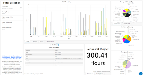
- Determine capabilities – What does your team need, what requests are coming in, what can you handle and where does your time actually go?

Kara’s team keeps a dashboard of time spent
- Communicate – Where are the places in your organization where you can communicate success, and where can you receive communications about needs?
- Commit – Staying on the path and trusting the process once you’ve established the first three steps, measuring success and reporting outcomes to key stakeholders
Want to dig into more details? If you’re in San Diego early for the Esri User Conference, you can join Kara and others at the GIS Managers Summit on June 9th – it's free for registered attendees to Esri's User Conference. If you can’t make the summit, Kara will be sharing more afterward, in the GIS Managers User Group in Esri Community. You can also read her ArcNews article detailing more.

Kara is the GIS Director for Franklin County, PA. Kara earned a Geo-Environmental Studies degree & GIS certificate from Shippensburg University in 2010. She earned both a Geospatial Programming and Web Map Development certificate from PennState and her GIS professional certification in 2021, and is planning to graduate with a Masters in GIS from PennState in the fall of 2023. In her free time, she chases after her 3 year old and likes to sew, garden, and take care of her chickens.