- Home
- :
- All Communities
- :
- ArcGIS Topics
- :
- GIS Life
- :
- GIS Life Discussions
- :
- Nearmap changes
- Subscribe to RSS Feed
- Mark Topic as New
- Mark Topic as Read
- Float this Topic for Current User
- Bookmark
- Subscribe
- Mute
- Printer Friendly Page
- Mark as New
- Bookmark
- Subscribe
- Mute
- Subscribe to RSS Feed
- Permalink
Hi all
Not sure if this is the optimum place for this, but couldn't really find a proper home for it.
Just wondering if anybody else has been having significant trouble with the latest changes to the Nearmap system? My company uses it for pretty basic stuff: find area, download georeferenced area at various scales, rinse and repeat.
The changes:
- have significantly increased the amount of clicks to get an aerial downloaded
- we now get a spammy email every time an aerial is downloaded
- worst of all, aerial imagery used to download with the metadata in the filename (CRS, date of image collection, resolution of image). Now it just downloads with the useless title 'Vert' or 'VertPhoto'. We now have to manually rename files (and world files) or separate into different folders when more than one aerial is downloaded.
In contacting support, the reason given for the latter change was the length of filename paths - but I've never encountered this issue myself (which of course doesn't mean it isn't an issue).
So, just wanted to gauge from my fellow GISers if this change has impacted them at all? If so, perhaps some emails to Nearmap to register your thoughts might be handy. I know we live in a world where services seem to get worse for the same amount of money, but perhaps this is one change we might be able to ameliorate...
- Mark as New
- Bookmark
- Subscribe
- Mute
- Subscribe to RSS Feed
- Permalink
Have to agree, our small business liked the old outputs much better, quicker for us. I thought maybe it was because sometimes outputs overlapped dates and the file name wasn't reflected as such.
- Mark as New
- Bookmark
- Subscribe
- Mute
- Subscribe to RSS Feed
- Permalink
G'day @VGTEnvironmental. Glad you agree! I thought I was shouting into the void and everybody else thought the changes were great. I did get an update from Support which said that they are going to revert to the old form of file naming - but there's no timeline for that as yet.
- Mark as New
- Bookmark
- Subscribe
- Mute
- Subscribe to RSS Feed
- Permalink
Just quick question, Why are you using the download not just adding the api, wms or wmts to your software?
- Mark as New
- Bookmark
- Subscribe
- Mute
- Subscribe to RSS Feed
- Permalink
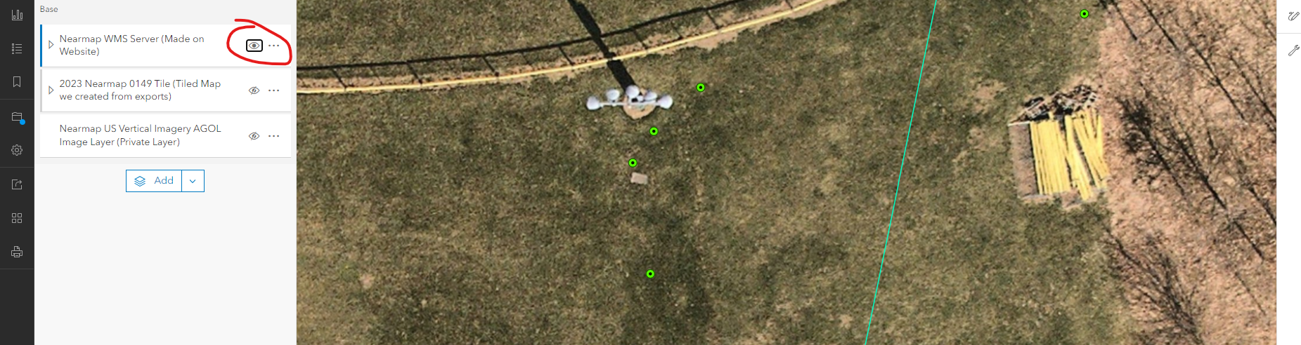
The api requires a network connection to view and it actually doesn't line up properly unfortunately. I have talked with them about this, and we got nowhere. So now I just make basemaps exporting their projected georeferenced images. The api is go for a quick glance or a vague view for referencing data.
The pictures I provided show how the shift is made in the api only, my basemap and the nearmap market place are correct. Nearmap even shared out city imagery with ESRI Community maps and its good there but the api still doesn't line up.
- Mark as New
- Bookmark
- Subscribe
- Mute
- Subscribe to RSS Feed
- Permalink
G'day @JoelPettiford and @Nick_Creedon . Sorry, missed these messages. This was investigated, but it completely nuked our data usage. Plus, we also like to have our jobs as self-contained as possible, so not relying on extraneous links like WMS/REST server etc. Don't know about you, but I find they are often broken when you revisit an old job.
Anyway, Nearmaps have implemented solutions to their 'improvements'. Data now downloads with proper metadata and the process has been more streamlined. Which is good, considering their subs went up...