- Home
- :
- All Communities
- :
- Networks
- :
- Esri Young Professionals Network
- :
- Esri YPN Networking
- :
- Re: Building a GIS Learning Ecosystem in School
- Subscribe to RSS Feed
- Mark Topic as New
- Mark Topic as Read
- Float this Topic for Current User
- Bookmark
- Subscribe
- Mute
- Printer Friendly Page
Building a GIS Learning Ecosystem in School

- Mark as New
- Bookmark
- Subscribe
- Mute
- Subscribe to RSS Feed
- Permalink
This article was originally published in Ukrainian. Following requests from members of the Esri Community, I am sharing the English version here to continue the conversation.
When I first introduced ArcGIS into our school, I believed success meant helping every teacher become confident with GIS.
I organized workshops, demonstrated tools, shared examples, and answered countless questions. Some colleagues immediately saw new possibilities. Others were genuinely interested—but after the workshop they simply returned to their daily routines.
At first, I thought the problem was motivation.
Now I think I was asking the wrong question.
The real question was never:
"How can every teacher learn GIS?"
It was:
"How can GIS help every teacher teach their own subject better?"
That realization changed everything.
As the head of our science department, I invited colleagues to do something very simple. Instead of starting with technology, we opened our annual teaching plans.
Together, we looked for topics where geospatial thinking could naturally strengthen learning.
The results surprised all of us.
Geography was the obvious place to start—but it certainly wasn't the only one.
Biology teachers discovered opportunities for field observations and environmental investigations.
History teachers suddenly had access to interactive historical maps that transformed discussions about past events.
Physics teachers began exploring terrain and elevation from completely new perspectives.
Computer science teachers found authentic datasets instead of artificial classroom examples.
Each teacher discovered different possibilities because each discipline asked different questions.
That became our model.
I stopped trying to turn every teacher into a GIS specialist.
Instead, I tried to become a translator between technology and pedagogy.
A history teacher does not need spatial analysis.
A biology teacher may never build a StoryMap.
Another colleague might only need Survey123 a few times each semester.
That is perfectly enough.
Teachers should remain experts in their own disciplines. My role is to help them discover which geospatial tools genuinely enrich their teaching—not to ask them to master an entire platform.
Then something unexpected happened.
Because every teacher used only a small part of the ArcGIS ecosystem, nobody felt overwhelmed.
Students, however, experienced something entirely different.
They encountered GIS in geography, then recognized familiar tools in biology, history, environmental science, and interdisciplinary projects. Some tools appeared repeatedly, each time solving a different problem.
Without realizing it, they were gradually building a much broader understanding of geospatial technologies than any single teacher.
One more surprise awaited us.
Our integrated lessons often refused to end when the bell rang.
Students kept asking questions.
Teachers kept discussing ideas.
Sometimes we found ourselves exploring possibilities we had never planned for.
Looking back, I realized those moments were the real outcome.
There are moments when curiosity becomes contagious. Students stop watching the clock. Teachers stop looking at the lesson plan. Everyone in the room becomes genuinely interested in the same question.
Over time, I realized that these are the moments that remind us why we chose to become educators.
Today, I no longer believe that successful GIS integration means creating many GIS experts within a school.
I believe it means creating an ecosystem.
One mentor who understands the technology.
Teachers who remain experts in their own disciplines.
Students who are free to connect ideas across subjects.
Technology should never become another burden for teachers.
It should quietly become part of the learning culture.
I'd love to hear how others approach this challenge.
How do you support meaningful GIS integration across different subjects without expecting every teacher to become a GIS specialist?
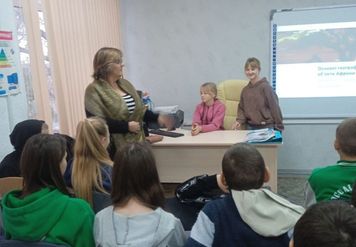
Photo: Geography, 7th grade. Students present their own GIS project, and the teacher becomes part of the discussion, not its center. Moments like these gradually changed my understanding of what successful GIS integration really means.
#EsriYPN #CyberDzhura

- Mark as New
- Bookmark
- Subscribe
- Mute
- Subscribe to RSS Feed
- Permalink
I wonder how many of the 191 World Changing Ideas for 2026 that fastcompany recently published will find their way into upcoming higher education research??? Of importance to me was seeing that ESRI was a winner for its Map Africa Initiative. Having been stationed for long periods in Mozambique, Angola and Somalia, AND currently promoting rural development in Kenya, I can attest that lots of GIS mentors are in need, and the one project at a time way of handing development needs to be super charged. But after so many years of conflict between Ukraine and Russia, or Israel and Palestine (as well as most neighbors) these may seem hallow words.
- Mark as New
- Bookmark
- Subscribe
- Mute
- Subscribe to RSS Feed
- Permalink
Thank you, William. I have come to believe that one of the greatest sources of resilience is the professional community itself. In difficult circumstances, it is easy to feel that you are “alone in the field.” Bringing GIS educators and practitioners together within a country—and connecting them with colleagues abroad—creates both practical support and renewed hope. This is one of the reasons I plan to initiate the process of establishing a Ukrainian Young Professionals Network (YPN) chapter in the near future: so that GIS experts, of whom there are already so few in the country, can have their own professional environment where they support one another, grow, and feel part of a larger international community.

- Mark as New
- Bookmark
- Subscribe
- Mute
- Subscribe to RSS Feed
- Permalink
Am really so happy to hear this discussion going on well i hope we could expound more @WilliamTarpai and I have been engaging kenya school helping them learn this new technology in so remote areas though we face challenges we usually strive to create an impact out of it am really happy to hear this conversation going on.This could be a beginning of change.
- Mark as New
- Bookmark
- Subscribe
- Mute
- Subscribe to RSS Feed
- Permalink
Thank you, Ezra. Your work in remote schools in Kenya is truly inspiring. I have just applied to the GeoRise global mentorship programme because I believe that initiatives like this help us build the international networks and mutual support we need to keep going, especially when we sometimes feel we are working alone. By sharing our experiences and learning from one another, we can create a much greater impact together.
- Mark as New
- Bookmark
- Subscribe
- Mute
- Subscribe to RSS Feed
- Permalink
Definitely hope you will share about how to help young people move forward during times of conflict.
- Mark as New
- Bookmark
- Subscribe
- Mute
- Subscribe to RSS Feed
- Permalink
@ChuncuiFan Sharing this post with young people, who are highly motivated to achieve would be great.
- Mark as New
- Bookmark
- Subscribe
- Mute
- Subscribe to RSS Feed
- Permalink
Дякую, Вільяме. Я буду радий поділитися нашим досвідом. У часи конфлікту допомога молодим людям рухатися вперед починається з надання їм надії, значущих навичок та відчуття приналежності до ширшої спільноти, що виходить за межі самої війни. Міжнародні зв'язки та наставництво є важливою частиною цієї подорожі.
- Mark as New
- Bookmark
- Subscribe
- Mute
- Subscribe to RSS Feed
- Permalink
Thank you @ЛюдмилаМандруляк and @WilliamTarpai I hope we can work together to advance this and also voice the same for both our local and international govements for help and support in whatever capacity
- Mark as New
- Bookmark
- Subscribe
- Mute
- Subscribe to RSS Feed
- Permalink
Thank you, Ezra—it means a lot to hear that this conversation feels like it could be the beginning of change. Remote schools in Kenya and a rural school in Ukraine are very different contexts, but the core challenge sounds the same: making GIS useful and sustainable with limited resources and support.
I'd love to learn more about your work—how do you introduce GIS to teachers who have little or no prior exposure, and what do you rely on most given connectivity constraints in remote areas?
I've spent the last several years building a similar model here, training teachers across subjects (not just geography) to use ArcGIS tools, even while operating under wartime conditions. Happy to share what's worked and what hasn't, if it's ever useful for your context too. Feel free to connect via LinkedIn whenever it's convenient.
- Mark as New
- Bookmark
- Subscribe
- Mute
- Subscribe to RSS Feed
- Permalink
Leeann Martinez | Nonprofit Account Manager sent me this message to Nonprofit Organizations that have registered for the upcoming Esri User Conference.
There will be a plethora of events, socials, and activities for you to attend. To help narrow down your options and strategically plan your week, I highly recommend that you review our custom GIS for Good Agenda.
In particular, I encourage you to:
- Visit the GIS for Good area in the Expo to connect with the Esri teams and users across the conservation, humanitarian, education, and nonprofit spaces.
- Join the Nonprofit Special Interest Group (SIG) to meet your peers and engage in a conversation around Nonprofits and GIS. Lunch will be provided! You must RSVP in advance, and you can do so here.
- Unwind at the GIS for Good Social on Tuesday at 6PM
The custom agenda includes a breakdown of activities specific to conservation, humanitarian, sustainable development, education, and climate
