- Home
- :
- All Communities
- :
- Networks
- :
- Esri Young Professionals Network
- :
- Esri YPN Networking
- :
- Building a GIS Learning Ecosystem in School
- Subscribe to RSS Feed
- Mark Topic as New
- Mark Topic as Read
- Float this Topic for Current User
- Bookmark
- Subscribe
- Mute
- Printer Friendly Page

- Mark as New
- Bookmark
- Subscribe
- Mute
- Subscribe to RSS Feed
- Permalink
This article was originally published in Ukrainian. Following requests from members of the Esri Community, I am sharing the English version here to continue the conversation.
When I first introduced ArcGIS into our school, I believed success meant helping every teacher become confident with GIS.
I organized workshops, demonstrated tools, shared examples, and answered countless questions. Some colleagues immediately saw new possibilities. Others were genuinely interested—but after the workshop they simply returned to their daily routines.
At first, I thought the problem was motivation.
Now I think I was asking the wrong question.
The real question was never:
"How can every teacher learn GIS?"
It was:
"How can GIS help every teacher teach their own subject better?"
That realization changed everything.
As the head of our science department, I invited colleagues to do something very simple. Instead of starting with technology, we opened our annual teaching plans.
Together, we looked for topics where geospatial thinking could naturally strengthen learning.
The results surprised all of us.
Geography was the obvious place to start—but it certainly wasn't the only one.
Biology teachers discovered opportunities for field observations and environmental investigations.
History teachers suddenly had access to interactive historical maps that transformed discussions about past events.
Physics teachers began exploring terrain and elevation from completely new perspectives.
Computer science teachers found authentic datasets instead of artificial classroom examples.
Each teacher discovered different possibilities because each discipline asked different questions.
That became our model.
I stopped trying to turn every teacher into a GIS specialist.
Instead, I tried to become a translator between technology and pedagogy.
A history teacher does not need spatial analysis.
A biology teacher may never build a StoryMap.
Another colleague might only need Survey123 a few times each semester.
That is perfectly enough.
Teachers should remain experts in their own disciplines. My role is to help them discover which geospatial tools genuinely enrich their teaching—not to ask them to master an entire platform.
Then something unexpected happened.
Because every teacher used only a small part of the ArcGIS ecosystem, nobody felt overwhelmed.
Students, however, experienced something entirely different.
They encountered GIS in geography, then recognized familiar tools in biology, history, environmental science, and interdisciplinary projects. Some tools appeared repeatedly, each time solving a different problem.
Without realizing it, they were gradually building a much broader understanding of geospatial technologies than any single teacher.
One more surprise awaited us.
Our integrated lessons often refused to end when the bell rang.
Students kept asking questions.
Teachers kept discussing ideas.
Sometimes we found ourselves exploring possibilities we had never planned for.
Looking back, I realized those moments were the real outcome.
There are moments when curiosity becomes contagious. Students stop watching the clock. Teachers stop looking at the lesson plan. Everyone in the room becomes genuinely interested in the same question.
Over time, I realized that these are the moments that remind us why we chose to become educators.
Today, I no longer believe that successful GIS integration means creating many GIS experts within a school.
I believe it means creating an ecosystem.
One mentor who understands the technology.
Teachers who remain experts in their own disciplines.
Students who are free to connect ideas across subjects.
Technology should never become another burden for teachers.
It should quietly become part of the learning culture.
I'd love to hear how others approach this challenge.
How do you support meaningful GIS integration across different subjects without expecting every teacher to become a GIS specialist?
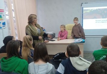
Photo: Geography, 7th grade. Students present their own GIS project, and the teacher becomes part of the discussion, not its center. Moments like these gradually changed my understanding of what successful GIS integration really means.
#EsriYPN #CyberDzhura

- Mark as New
- Bookmark
- Subscribe
- Mute
- Subscribe to RSS Feed
- Permalink
WOW. Thanks for posting in Ukrainian, on a topic of REAL IMPORTANCE for a majority of those who have not fully mastered English, but are interested in mastering GIS skills. I have been pushing my colleagues in Kenya, to begin to introduce GIS skill sets, especially in high schools in rural areas, and face many of the challenges you address.
I urge leaders of this ESRI COMMUNITY to ensure a full translation into English can be posted soon on this platform, hopefully before this year's UC.
- Mark as New
- Bookmark
- Subscribe
- Mute
- Subscribe to RSS Feed
- Permalink
William, thank you so much for your thoughtful comment. It means a great deal to discover that educators working in such different contexts as Ukraine and Kenya are facing remarkably similar challenges. My original intention was actually to publish the article in English, so I suspect there may have been an issue with how the platform displayed the content. I'll look into it. More importantly, I truly hope this conversation continues, because I believe we have much to learn from one another about building sustainable GIS education in schools.
- Mark as New
- Bookmark
- Subscribe
- Mute
- Subscribe to RSS Feed
- Permalink
Perhaps becoming a bridge between technology and pedagogy may perhaps be more useful - @EzraCheruiyot Perhaps we need to address these topics with teachers and administrators of all the schools we have already supplied reading materials and computer equipment??? Let's discuss this topic during our next mapping hour.....
- Mark as New
- Bookmark
- Subscribe
- Mute
- Subscribe to RSS Feed
- Permalink
William, your comment made me smile because this is exactly the conclusion I reached after several years of trying different approaches. Supplying schools with technology is essential—but technology alone rarely changes classroom practice. In my experience, the real catalyst is building a bridge between technology, pedagogy, school leadership, and subject teachers. Once these pieces begin working together, GIS stops being "someone else's tool" and becomes part of the school's learning ecosystem. I'd be delighted if these ideas contribute to your next Mapping Hour discussion.

- Mark as New
- Bookmark
- Subscribe
- Mute
- Subscribe to RSS Feed
- Permalink
Приємно читати аналітику про "другий рівень Кіберджури". А тема першого рівня уже була розкрита для спільноти Esri?
- Mark as New
- Bookmark
- Subscribe
- Mute
- Subscribe to RSS Feed
- Permalink
It keeps getting better and better.. Thanks for putting up the translation as the English speaking ESRI Community iwill go wild about the simplicity of thinking that can make good things happen. AI for Good is happening in Geneva NOW. ESRI UC and HLPF for Sustainable Development will be happening in New York and San Diego next week. GIS leadership can make incredible things related to the SDGs happen during the rest of this decade. But while we can appreciate America First, we really need to know the world is a big place.
- Mark as New
- Bookmark
- Subscribe
- Mute
- Subscribe to RSS Feed
- Permalink
William, thank you for your encouraging words and for taking the time to engage so thoughtfully with the article.
I truly believe that meaningful GIS leadership begins in classrooms, where teachers and students learn to solve real problems together. If we can help schools build confidence in using geospatial thinking, we are already contributing to the Sustainable Development Goals—one lesson, one project, and one community at a time.
It is inspiring to see that educators from different parts of the world recognize the same challenges and are willing to learn from one another. That, perhaps, is one of the greatest strengths of the Esri Community.


- Mark as New
- Bookmark
- Subscribe
- Mute
- Subscribe to RSS Feed
- Permalink
Amazing! I love the approach of connecting the expert with the geospatial tool that supports them within their discipline. Awesome to hear about the impact that GIS integration is having on students in your school as they become exposed to it across disciplines!
- Mark as New
- Bookmark
- Subscribe
- Mute
- Subscribe to RSS Feed
- Permalink
Thank you, Nico! That was exactly the idea behind our approach. We realized that meaningful GIS integration does not require every teacher to become a GIS specialist. Instead, one experienced mentor can support colleagues by matching the right geospatial tool to the needs of each subject, while subject teachers contribute their disciplinary expertise. This allows students to encounter GIS naturally across different lessons, building both technical skills and interdisciplinary thinking.
