- Home
- :
- All Communities
- :
- User Groups
- :
- Esri Forestry Group (EFG)
- :
- Questions
- :
- Looking for suggestions on interactive script edit...
- Subscribe to RSS Feed
- Mark Topic as New
- Mark Topic as Read
- Float this Topic for Current User
- Bookmark
- Subscribe
- Mute
- Printer Friendly Page
Looking for suggestions on interactive script editing to determine Gradient
- Mark as New
- Bookmark
- Subscribe
- Mute
- Subscribe to RSS Feed
- Permalink
This is an excerpt from earlier discussions relating to forestry roads, The modelling has matured a little to the point the user wants to add new flat features along the road at user defined elevations and force the calculation of gradient to be set by the heights of these features. These features for the initial stage do not have elevation but need to be assigned this value somewhere through this process (either before or during the calculation of Gradient of the roads that join these flat areas.
Editing 3D polyline values now becomes more complex in Hikurangi Forest Farms Ltd's blog posts
Hikurangi Forest Farms Ltd wrote3 weeks ago
Earlier leading Discussion
I have a Polyline Feature class that I wish to maintain in 3D Editing
Xander Bakker Suggested I Branch this off the original discussion
Basically what I am doing is I have a polyline that I apply a Start and Finish Z Value to an attribute via Xanders Python script he had written in my earlier topic.
But now I wish to introduce another feature class Polygon that intersects these Polylines at a static height part way through this PolyLine, and it derives it's own height from a user defined range similar to but not exactly at the same altitude as the underlying surface,
this in fact makes a section of the poly line the same height as that polygon over the area of that polygon
I will add some demo data to explain
in Hikurangi Forest Farms Ltd's blog postsLike (0)
• Comment • Share
Actions Hide new activityStart following in InboxMark unreadMark read
4 comments1 new update Show earlier
I revised the ige file and it seems that the clip was performed maintaining the extent of the input DEM. This is why the compression is so high.
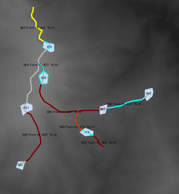
I see you intersected the roads with the "skid" polygons. There are however a few aspects I don't quite understand:
- I would expect the road to assume the elevation of the skid polygon if it crosses it and in this polygon it doesn't
- I would also expect that the road would end at the "skid" elevation. In this example it doesn't.
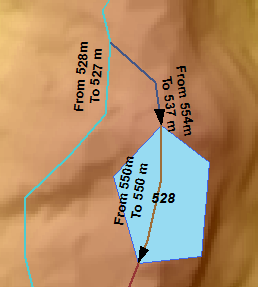
- The two roads (cyan and blue) connect, but the from height for the blue road is 554, while the elevation of the cyan would be between 527 and 528. In that case they don't match at the intersection. This could be solved if the cyan road would be split at the intersection and the tool would be executed again.
It would be good to include the URL to thread you refer to: I have a Polyline Feature class that I wish to maintain in 3D Editing
Sorry I have been away, Needed time out and away from the slow pace of life on the coast.
Sadly Xander Bakker your assumptions are not altogether what I was trying to achieve.
What I was trying to demonstrate here is that the Skid is a height not defined by the entry or exit elevation of the road that intersects it. But by a nominated height value that the entity that will in the future build the landing at decides on. So in effect they are lifting or dropping the road end height to a value that is not derived from the Surface but a dead reckoning value that is determined really on engineering principles of not moving too much dirt around . I.e. if the dirt in hillside they cut part of the landing from is equal to say 20cubic metres of dirt, they now have 20 cubic metres of dirt to fill the road(s) up to the landing height or fill part of the landing to make a flat surface to work from.
This also means that this flat surface determines the start height of the next section of road and the underlying original surface is altered in elevation by it in a physical sense. but from this planning phase the height is merely a constant value a harvest planner has keyed into the skid height field.
Does this make sense.
I am a complete noob when it comes to using these forums for anything really. how would I go about linking to the URL of our first discussion, and where are the toolsets to create a new discussion...or move this into such an enivironment? Thanks Mat
![]()
Hi Hikurangi Forest Farms Ltd ,
I don't think you can convert an existing blog post into a discussion, but you can create a new discussion (mark it as a question) and copy the content of your post into the new thread (and attach the data):
To include a link to the other thread you can copy this link I have a Polyline Feature class that I wish to maintain in 3D Editing into the thread when you create it.
I think it is possible to write a script that extracts the height of the skids and if not available at start of end point to use the height of the DEM and define the slope of the road based on that.
- Mark as New
- Bookmark
- Subscribe
- Mute
- Subscribe to RSS Feed
- Permalink
I guess for this specific case it would be better to create a script or toolbox that will analyze and generate the values for the gradient of the road based on the script posted here: Re: I have a Polyline Feature class that I wish to maintain in 3D Editing
Inputs would be:
- Roads
- The polygons, height field
- DEM
It should intersect the roads and the polygons, and leave start and end height to the polygons when the part of the road intersects with the polygon, extract the polygon height if start or end touches a polygon and otherwise extracts the elevation from the DEM.
Hi Hikurangi Forest Farms Ltd ,
I think it is better to post this not as a blog but as a new question (discussion). A blog does not offer the tools for others to include code highlighting and attachments.
The roads.zip contains a file "easte_clip.ige" that decompresses to > 4 GB... that's a pretty big file. Are you sure it is the most efficient format for this data?
Like (0)
•
Helpful Yes | No •
Actions