Turn on suggestions
Auto-suggest helps you quickly narrow down your search results by suggesting possible matches as you type.
Cancel
- Home
- :
- All Communities
- :
- Products
- :
- Data Management
- :
- Data Management Questions
- :
- �??US Dual Range Addresses�?� style issue,
Options
- Subscribe to RSS Feed
- Mark Topic as New
- Mark Topic as Read
- Float this Topic for Current User
- Bookmark
- Subscribe
- Mute
- Printer Friendly Page
�??US Dual Range Addresses�?� style issue,
Subscribe
7525
16
04-06-2014 09:18 AM
04-06-2014
09:18 AM
- Mark as New
- Bookmark
- Subscribe
- Mute
- Subscribe to RSS Feed
- Permalink
�??US Dual Range Addresses�?� style issue,
I wanted to apply the �??US Dual Range Addresses�?� style but it appears that the searched addresses don�??t match the exact location of the target building.
For example, in the screenshot below, I wanted to search the �??5 peace street, Ramallah�?�. The result doesn�??t match the precise physical location of the building. In other words, how to have the location of the found building just precisely in front of the building. The schema is also shown in the screenshot.
[ATTACH=CONFIG]32846[/ATTACH]
I still need to use the �??Street�?� layer as REFERENCE DATA but I�??m looking for having the precise location of the searched building.
What other options I might still have?
Thank you
Best
Jamal
----------------------------------------
Jamal Numan
Geomolg Geoportal for Spatial Information
Ramallah, West Bank, Palestine
Jamal Numan
Geomolg Geoportal for Spatial Information
Ramallah, West Bank, Palestine
16 Replies
04-09-2014
04:07 AM
- Mark as New
- Bookmark
- Subscribe
- Mute
- Subscribe to RSS Feed
- Permalink
Thats right, this is your only option, since you can place those points directly on structures.
I work in 911 and our mapping system works with about 8 different locators. The first locator we are looking in is the Single House locator, to get the most precise location. If no point is found it defaults to our dual range locator. As long as the ranges are correct, it will at least gets you as close as possible to the real address.
I work in 911 and our mapping system works with about 8 different locators. The first locator we are looking in is the Single House locator, to get the most precise location. If no point is found it defaults to our dual range locator. As long as the ranges are correct, it will at least gets you as close as possible to the real address.
04-10-2014
03:27 AM
- Mark as New
- Bookmark
- Subscribe
- Mute
- Subscribe to RSS Feed
- Permalink
Thats right, this is your only option, since you can place those points directly on structures.
I work in 911 and our mapping system works with about 8 different locators. The first locator we are looking in is the Single House locator, to get the most precise location. If no point is found it defaults to our dual range locator. As long as the ranges are correct, it will at least gets you as close as possible to the real address.
Thank you Tim for the valuable input.
It is clear now that we need to create more than one locater (as you did guys) and basically Single House and Dual Range, and next to apply the composite geocoding of the ArcGIS.
Best
Jamal
----------------------------------------
Jamal Numan
Geomolg Geoportal for Spatial Information
Ramallah, West Bank, Palestine
Jamal Numan
Geomolg Geoportal for Spatial Information
Ramallah, West Bank, Palestine
04-18-2014
11:59 AM
- Mark as New
- Bookmark
- Subscribe
- Mute
- Subscribe to RSS Feed
- Permalink
Jamal,
The "Dual Ranges" style uses interpolation as an approximation of the position along the street that an address should be. The only style that would be more precise would be the "Single House" style which would require an address point for each house. Is there a reason that the exact location is needed for the geocode? If so, the "Single House" style is your only option and will require a lot of work to add every house to the dataset.
Brad
Hi Brad,
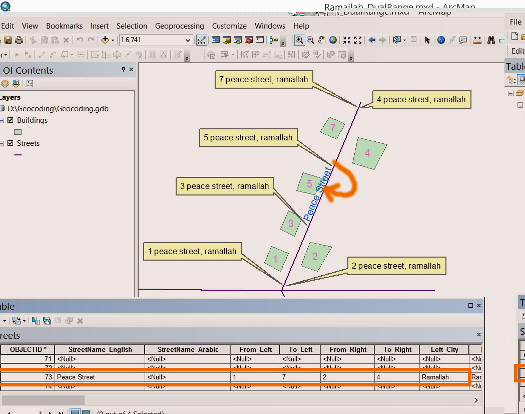
I couldn�??t precisely figure out how the interpolation works in the �??Dual Range�?� style.
For example, in the screenshot below, the length of the �??peace street�?� is 584 meters. The �??From_Left�?� value is 1
and the �??To_Left�?� is 7.
[ATTACH=CONFIG]33204[/ATTACH]
This means that we have 4 buildings in the Left: 1, 3, 5 and 7. In my understanding, the �??peace street�?� is divided into 4 equal segments and the address of these 4 building is centered at the middle of these segments as shown below:
[ATTACH=CONFIG]33205[/ATTACH]
When the �??Dual Range�?� style is applied, the 4 addresses that are located on the left of peace street are displayed as shown in the screenshot below:
[ATTACH=CONFIG]33206[/ATTACH]
This reveals the first address (1 peace street) and last address (7 peace street) are NOT located at the middle of the first and fourth segments according the �??Dual Range�?� style
What might explain this issue?
----------------------------------------
Jamal Numan
Geomolg Geoportal for Spatial Information
Ramallah, West Bank, Palestine
Jamal Numan
Geomolg Geoportal for Spatial Information
Ramallah, West Bank, Palestine
04-18-2014
12:27 PM
- Mark as New
- Bookmark
- Subscribe
- Mute
- Subscribe to RSS Feed
- Permalink
Jamal,
What you describe below is incorrect. With the Dual Ranges style the first address in the range is right at the beginning of the street segment and the last address in the range is at the very end of the segment. The points will not be at the very beginning and the very end of the segment because of the property "EndOffset" which will offset the matches on the beginning and end of the street segment by a certain skew factor (3% by default).
Brad
04-18-2014
02:07 PM
- Mark as New
- Bookmark
- Subscribe
- Mute
- Subscribe to RSS Feed
- Permalink
Jamal,
What you describe below is incorrect. With the Dual Ranges style the first address in the range is right at the beginning of the street segment and the last address in the range is at the very end of the segment. The points will not be at the very beginning and the very end of the segment because of the property "EndOffset" which will offset the matches on the beginning and end of the street segment by a certain skew factor (3% by default).
Brad
Sorry for the confusion.
What I wanted to say is that I couldn�??t figure out how the interpolation of the Geocoding works.
In case of having From_Left is 1 and To_Left is 7, then does the �??Dual Range�?� style divide the "left" streets into 4 equal segments (1, 3, 5 and 7) and locate the geocoded address at the middle of each segment? If not, what does it do with these 4 equal segments? Where the geocoded addresses are �??plotted�?� in relation to these 4 segments?
----------------------------------------
Jamal Numan
Geomolg Geoportal for Spatial Information
Ramallah, West Bank, Palestine
Jamal Numan
Geomolg Geoportal for Spatial Information
Ramallah, West Bank, Palestine
04-18-2014
10:26 PM
- Mark as New
- Bookmark
- Subscribe
- Mute
- Subscribe to RSS Feed
- Permalink
Jamal,
Please see the attached image and let me know if you are still confused.
The first segment shows where the points would be if there was no End Offset and the second segment shows where the points would be if there was End Offset of 3%.
Brad
It appears that my idea is not arrived.
What I meant is that the approach used in the Geocoding with the �??dual range�?� style is not logic. What I�??m proposing is that the geocoding �??algorithm�?� should be re-structured to match the reality when addresses are geocoded.
Suggestions
Suppose we have 4 buildings at the Left of the street (1, 3, 5 and 7), then
1. The Left street should be virtually divided into 4 equal segments
[ATTACH=CONFIG]33213[/ATTACH]
2. The address should be located at the midpoint of these 4 segment when geocoded
[ATTACH=CONFIG]33214[/ATTACH]
By logic, the address is better to be �??plotted�?� at the MIDDLE but not at the start or end of each building\parcel\segment.
----------------------------------------
Jamal Numan
Geomolg Geoportal for Spatial Information
Ramallah, West Bank, Palestine
Jamal Numan
Geomolg Geoportal for Spatial Information
Ramallah, West Bank, Palestine
- « Previous
-
- 1
- 2
- Next »
- « Previous
-
- 1
- 2
- Next »