Turn on suggestions
Auto-suggest helps you quickly narrow down your search results by suggesting possible matches as you type.
Cancel
- Home
- :
- All Communities
- :
- Products
- :
- Data Management
- :
- Data Management Questions
- :
- Parcel Editing
Options
- Subscribe to RSS Feed
- Mark Topic as New
- Mark Topic as Read
- Float this Topic for Current User
- Bookmark
- Subscribe
- Mute
- Printer Friendly Page
Parcel Editing
Subscribe
888
0
07-22-2013 08:07 AM
07-22-2013
08:07 AM
- Mark as New
- Bookmark
- Subscribe
- Mute
- Subscribe to RSS Feed
- Permalink
Good morning everyone,
I'm not to familiar with ArcMap Parcel Editing Tools and had a few questions:
First when creating/generating new parcels is it possible to create based on area, minimum frontage, frontage offsets, minimum width and max depth.
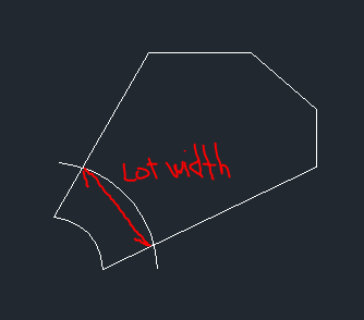
Is it possible to create lots on a curve with a minimum frontage and offset? (see attached photo).
My final question, are parametes remembered during editing/revising? For example, if you move a lot line of a parcel will the tool adhere to the original rule/parameter of the minimum lot width, area or other parameter?
Thanks in advance,
Devon
I'm not to familiar with ArcMap Parcel Editing Tools and had a few questions:
First when creating/generating new parcels is it possible to create based on area, minimum frontage, frontage offsets, minimum width and max depth.
Is it possible to create lots on a curve with a minimum frontage and offset? (see attached photo).
My final question, are parametes remembered during editing/revising? For example, if you move a lot line of a parcel will the tool adhere to the original rule/parameter of the minimum lot width, area or other parameter?
Thanks in advance,
Devon
0 Replies