- Home
- :
- All Communities
- :
- Products
- :
- Data Management
- :
- Data Management Questions
- :
- Local projection to UTM 9
- Subscribe to RSS Feed
- Mark Topic as New
- Mark Topic as Read
- Float this Topic for Current User
- Bookmark
- Subscribe
- Mute
- Printer Friendly Page
Local projection to UTM 9
- Mark as New
- Bookmark
- Subscribe
- Mute
- Subscribe to RSS Feed
- Permalink
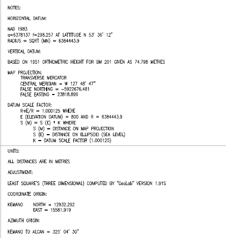
I have data in a local projection. I want to convert it to UTM zone 9. I have the control drawing and a word doc on how to convert the data to utm projection in Cad but I don't know how to use the data in Arc.
The coordinate system of the data stats that it is in UTM 9 but it shows up by the equator in the middle of the pacific instead of northern British Columbia. I believe that I need to use the data for the local projection but I have been unsuccessful in doing this.
- Mark as New
- Bookmark
- Subscribe
- Mute
- Subscribe to RSS Feed
- Permalink
Did you try to redefine the coordinate system to UTM zone 9N using the Define Projection tool or the data's property page? That won't work as it just updates the metadata. You would need to use the Project Tool or georeference the data directly to UTM zone 9N. If you include the information on how to convert it in AutoCAD here someone might be able to help. Also, if you email me (mkennedy at esri), I can send you two documents that discuss how to work with data in a local coordinate system.
Melita
- Mark as New
- Bookmark
- Subscribe
- Mute
- Subscribe to RSS Feed
- Permalink
Are these documents available online?
- Mark as New
- Bookmark
- Subscribe
- Mute
- Subscribe to RSS Feed
- Permalink
Hi Sarah,
They aren't, but send me an email (mkennedy at esri dot com) and I'll send them to you.
Melita
- Mark as New
- Bookmark
- Subscribe
- Mute
- Subscribe to RSS Feed
- Permalink
Thanks Melita. Projecting the data in UTM 9 doesn't work as the data is a local projection. When I project it in UTM 9 it shows up in the ocean by the equator.
To convert the data from Kemano Local to UTM grid in AutoCad is as follows.
TO CONVERT FROM LOCAL TO UTM GRID
1. MAKE A BLOCK OF THE OBJECTS TO BE MOVED.
2. SCALE THE BLOCK BY 0.999533 AT THE KEMANO BASEPOINT [E 15581.919, N 12932.292 ].
3. ROTATE THE BLOCK 0.8414194 DEGREES COUNTERCLOCKWISE ABOUT THE KEMANO BASEPOINT.
4. MOVE THE BLOCK 554840.756m EAST AND 5920078.794m NORTH.
Below is the information that I received from the engineering company about the local coordinate system.
- Mark as New
- Bookmark
- Subscribe
- Mute
- Subscribe to RSS Feed
- Permalink
I hope the documents I sent you are helpful. What happens if you try this WKT? Make is a .prj file and browse to it to set the data frame or the data's coordinate system. Make sure it's a single line in the text file.
PROJCS["NAD_1983_UTM_Zone_9N",GEOGCS["GCS_North_American_1983",DATUM["D_North_American_1983",SPHEROID["GRS_1980",6378137.0,298.257222101]],PRIMEM["Greenwich",0.0],UNIT["Degree",0.0174532925199433]],PROJECTION["Transverse_Mercator"],PARAMETER["False_Easting",23818.899],PARAMETER["False_Northing",-5922676.481],PARAMETER["Central_Meridian",-127.81305555556],PARAMETER["Scale_Factor",1.000125],PARAMETER["Latitude_Of_Origin",0.0],UNIT["Meter",1.0]]
Melita