- Home
- :
- All Communities
- :
- Products
- :
- Data Management
- :
- Data Management Questions
- :
- Re: Geocoding intersections with an offset based o...
- Subscribe to RSS Feed
- Mark Topic as New
- Mark Topic as Read
- Float this Topic for Current User
- Bookmark
- Subscribe
- Mute
- Printer Friendly Page
Geocoding intersections with an offset based on a field with a distance
- Mark as New
- Bookmark
- Subscribe
- Mute
- Subscribe to RSS Feed
- Permalink
- Report Inappropriate Content
Hi Folks,
I am trying to geocode some accident collision data (intersection) but each intersection point is defined with an offset distance and direction of the collision. For example: a collision at an intersection of two streets has a field saying that it is, n N (north), 25m, one field has 25 and the other has the N.
Any ideas how I can geocode these intersections with the offset?
Thanks
Larisa
- Mark as New
- Bookmark
- Subscribe
- Mute
- Subscribe to RSS Feed
- Permalink
- Report Inappropriate Content
Larisa:
It is possible to search for the intersection using a spatial offset, but the input address needs to be in the following format:
[distance] [units] [direction] from [address] for example 25 meters N from juniper st ne & 6th St ne, atlanta
You would need to use the Field Calculator to populate a new field in your table with the spatial offset and intersection addresses using the above format. Then the new field could be used for batch geocoding.
- Mark as New
- Bookmark
- Subscribe
- Mute
- Subscribe to RSS Feed
- Permalink
- Report Inappropriate Content
I have tried doing what Shana Britt posted, but it does not work for me. I have tried formatting both in the attribute table and in the geocoding toolbar but it does not do any offsets.
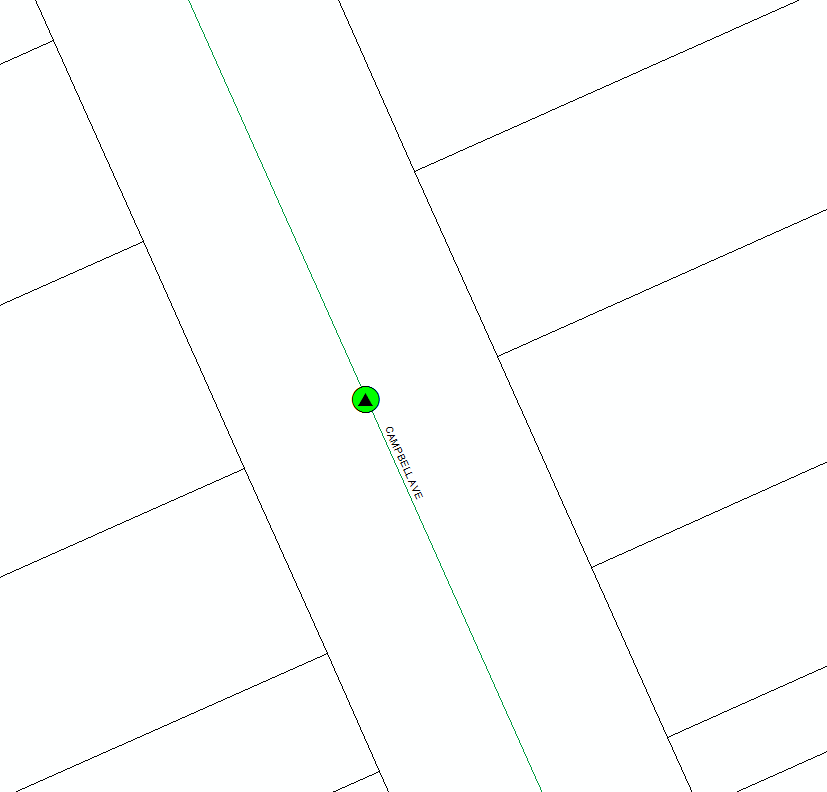
I geocoded the same table using the column that has not been modified first, to get a set of original base points. This is shown as the green point in the image below. Then I geocoded based on the new column that was modified in the following format: [distance] [units] [direction] from [address] as suggested. This is shown as the black triangle in the image below. As you can see, there has not been any offsetting with or without the format applied.

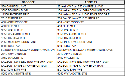
This is the attribute table with the original input (GEOCODE) and with the modified formatting (ADDRESS):

Am i doing something wrong?
- Mark as New
- Bookmark
- Subscribe
- Mute
- Subscribe to RSS Feed
- Permalink
- Report Inappropriate Content
Having this exact same issue. Has anyone found a solution? Jovana Burz Shana Britt Larisa Johnstone
- Mark as New
- Bookmark
- Subscribe
- Mute
- Subscribe to RSS Feed
- Permalink
- Report Inappropriate Content
Nikhil:
Did you try my suggestion above? Are you able to provide a small sample of your data?
- Mark as New
- Bookmark
- Subscribe
- Mute
- Subscribe to RSS Feed
- Permalink
- Report Inappropriate Content
Hi Shana,
I tried following the format [distance] [units] [direction] from [address] but the default address locator (ArcGIS World Geocoding Service) does not provide the offset location from an intersection.
For example, in San Francisco, I am looking at the intersection of Market St and 7th St. The address locator can identify the intersection, but when I try "100 feet W from Market St & 7th St", the result is just the intersection without an offset.
Any help would be appreciated.
- Mark as New
- Bookmark
- Subscribe
- Mute
- Subscribe to RSS Feed
- Permalink
- Report Inappropriate Content
Nikhil:
The information above does not apply to the ArcGIS World Geocoding Service, it only applies to address locators that you create using the Create Address Locator tool in ArcMap or ArcGIS Pro. You would have to use your own or commercial reference data to build your own locator to be able to use what I've described above.
- Mark as New
- Bookmark
- Subscribe
- Mute
- Subscribe to RSS Feed
- Permalink
- Report Inappropriate Content
Could anyone figure this out? I am trying to do a similar problem where the location that I have is in reference to intersecting street e.g. 10 meters north of "some street address"?
- Mark as New
- Bookmark
- Subscribe
- Mute
- Subscribe to RSS Feed
- Permalink
- Report Inappropriate Content
NO, I have never found a solution for this.
- Mark as New
- Bookmark
- Subscribe
- Mute
- Subscribe to RSS Feed
- Permalink
- Report Inappropriate Content
Does searching with the spatial offset work for you in the Find tool or Geocoding Toolbar in ArcMap or the Locate pane in ArcGIS Pro when using a locator you created with the Create Address Locator tool, but does not work when batch geocoding a table?