Turn on suggestions
Auto-suggest helps you quickly narrow down your search results by suggesting possible matches as you type.
Cancel
- Home
- :
- All Communities
- :
- Products
- :
- Data Management
- :
- Data Management Questions
- :
- Geocoding 10.0 SP4 issue with 'Match_addr' coming ...
Options
- Subscribe to RSS Feed
- Mark Topic as New
- Mark Topic as Read
- Float this Topic for Current User
- Bookmark
- Subscribe
- Mute
- Printer Friendly Page
Geocoding 10.0 SP4 issue with 'Match_addr' coming up w/ "2106 PACIFIC AV, TA, 98402"?
Subscribe
3215
2
04-27-2012 08:56 PM
by
Anonymous User
Not applicable
04-27-2012
08:56 PM
- Mark as New
- Bookmark
- Subscribe
- Mute
- Subscribe to RSS Feed
- Permalink
Original User: gwlgis
Scenario:
Simple Geocoding function, using ArcInfo 10.0 SP4.
Used 'US Addresses - Dual Ranges' because I have Line data as my reference (From Left, To Left, From Right, To Right, etc.)
My table to be geocoded has (among others) these 4 fields: address '2106 Pacific Ave' City 'Tacoma' State "WA" and Zip '98402'
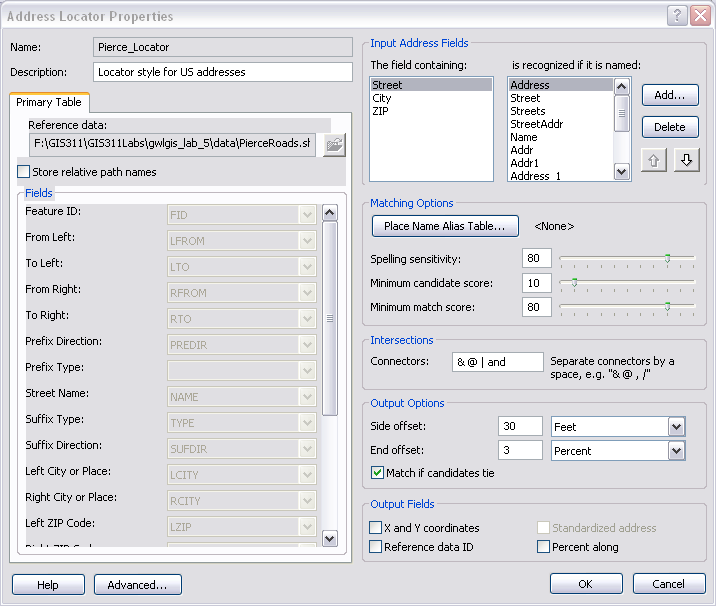
I have: 'The field containing:' all set up by default Street-street, City-city, and Zip-zip.
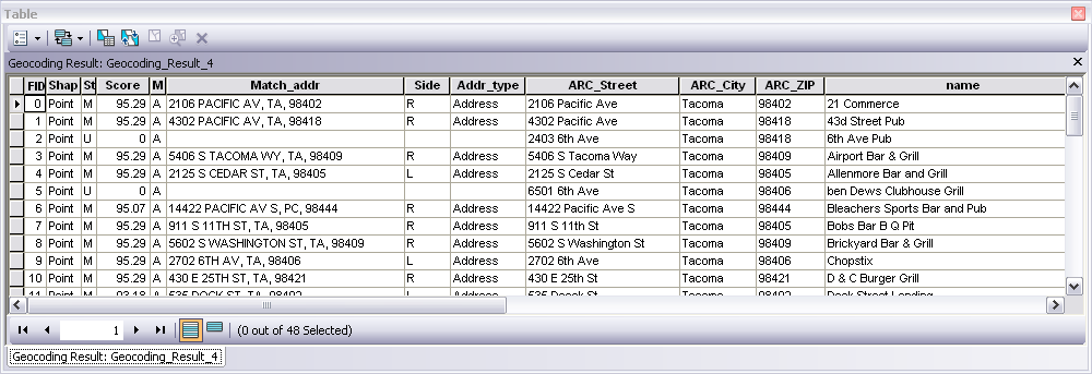
In the results however, the 'Match_addr' field comes up with the abbreviated city as 'TA' as though it was a state abbreviation.
But it was Tacoma.
Also, the matches are coming up with 95.29 percent.
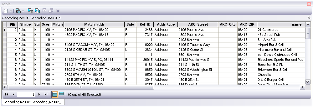
I found a work-around, by (in the Address Locator Properties) clicking on 'City' in "The field containing:", and then deleting all of the items in "is recognized if it is named:" I run it after that and I get 100% matches, on all the matches that were formerly 95.29.
Image of my initial Address Locator below.
[ATTACH=CONFIG]13904[/ATTACH]
Geocode result 1 below.
[ATTACH=CONFIG]13905[/ATTACH]
Image of my 2nd (the fix) Address Locator below
[ATTACH=CONFIG]13906[/ATTACH]
Geocode results showing 100% for same exact Address locator, except with the city taken out. (still have "TA" for Tacoma.)
[ATTACH=CONFIG]13907[/ATTACH]
Exact same thing, except without the city stuff, I get 100%.
Is it safe to say that there is something wrong?
I can continue this work around, but it would be great if it could/would work properly.
by the way, I am an instructor and this is a Lab that was designed for my students by a professor at the college. It worked fine in 9.2 and 9.3, but with the switch to 10.0 SP1, SP2, SP3 and SP4 all have this issue.
Any input would be greatly appreciated!
Thanks
Greg Lund
Scenario:
Simple Geocoding function, using ArcInfo 10.0 SP4.
Used 'US Addresses - Dual Ranges' because I have Line data as my reference (From Left, To Left, From Right, To Right, etc.)
My table to be geocoded has (among others) these 4 fields: address '2106 Pacific Ave' City 'Tacoma' State "WA" and Zip '98402'
I have: 'The field containing:' all set up by default Street-street, City-city, and Zip-zip.
In the results however, the 'Match_addr' field comes up with the abbreviated city as 'TA' as though it was a state abbreviation.
But it was Tacoma.
Also, the matches are coming up with 95.29 percent.
I found a work-around, by (in the Address Locator Properties) clicking on 'City' in "The field containing:", and then deleting all of the items in "is recognized if it is named:" I run it after that and I get 100% matches, on all the matches that were formerly 95.29.
Image of my initial Address Locator below.
[ATTACH=CONFIG]13904[/ATTACH]
Geocode result 1 below.
[ATTACH=CONFIG]13905[/ATTACH]
Image of my 2nd (the fix) Address Locator below
[ATTACH=CONFIG]13906[/ATTACH]
Geocode results showing 100% for same exact Address locator, except with the city taken out. (still have "TA" for Tacoma.)
[ATTACH=CONFIG]13907[/ATTACH]
Exact same thing, except without the city stuff, I get 100%.
Is it safe to say that there is something wrong?
I can continue this work around, but it would be great if it could/would work properly.
by the way, I am an instructor and this is a Lab that was designed for my students by a professor at the college. It worked fine in 9.2 and 9.3, but with the switch to 10.0 SP1, SP2, SP3 and SP4 all have this issue.
Any input would be greatly appreciated!
Thanks
Greg Lund
2 Replies
by
Anonymous User
Not applicable
04-30-2012
05:09 AM
- Mark as New
- Bookmark
- Subscribe
- Mute
- Subscribe to RSS Feed
- Permalink
Original User: MOelschlegal
Greg,
The TA is either taken from another field in your reference data or it is an abbreviation within the address locator lot.xml file. You are correct in removing the fields names from the "is recognized if it is named:" list. Did you build the locator?
Matt
Greg,
The TA is either taken from another field in your reference data or it is an abbreviation within the address locator lot.xml file. You are correct in removing the fields names from the "is recognized if it is named:" list. Did you build the locator?
Matt
05-07-2012
07:53 AM
- Mark as New
- Bookmark
- Subscribe
- Mute
- Subscribe to RSS Feed
- Permalink
Greg,
The TA is either taken from another field in your reference data or it is an abbreviation within the address locator lot.xml file. You are correct in removing the fields names from the "is recognized if it is named:" list. Did you build the locator?
Matt
Matt (and anyone else who reads)...
Yes, it appears that TA is taken from the 'City' field which, for all of the addresses, is 'Tacoma'.
I built the Address Locator.
I was thinking that the list of "is recognized if it is named:" could be left in for most fields, perhaps I should just leave the one in there that applies to my data.
Regards,
Greg