- Home
- :
- All Communities
- :
- User Groups
- :
- Coordinate Reference Systems
- :
- Questions
- :
- How to overcome "empty output generated" error mes...
- Subscribe to RSS Feed
- Mark Topic as New
- Mark Topic as Read
- Float this Topic for Current User
- Bookmark
- Subscribe
- Mute
- Printer Friendly Page
How to overcome "empty output generated" error message
- Mark as New
- Bookmark
- Subscribe
- Mute
- Subscribe to RSS Feed
- Permalink
Hallo everybody, I am using a map polygon to clip data (shape file). Both data were projected to a new coordinate reference system (WGS 84 or Ghana Meter Grid). But the clip tool is throwing an exception "empty output generated". I have checked the log file but has not identified any conflict although the system suggests extents may have to be reset. I started by projecting both data to WGS 84 before clipping but changed to Ghana Meter grid to see if the result will be different, but both gave the same error message. I also stored both in a gdb, and the output also in a gdb. Any idea what i could be doing wrong?
Solved! Go to Solution.
Accepted Solutions
- Mark as New
- Bookmark
- Subscribe
- Mute
- Subscribe to RSS Feed
- Permalink
Chris, you may have a point because i tried clipping other layers without a z value and it has successfully clipped. I am yet to try all the others. In the mean time, what are my options?
- Mark as New
- Bookmark
- Subscribe
- Mute
- Subscribe to RSS Feed
- Permalink
copy the results of the two file extents here... a visual confirmation of overlaps is not sufficient. Empty outputs can occur when the tw files dont' share the same extents
- Mark as New
- Bookmark
- Subscribe
- Mute
- Subscribe to RSS Feed
- Permalink
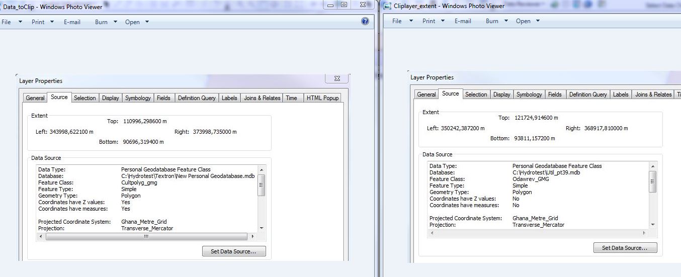
Dan, the extent at the right is the clip layer while the one on the left is the data to be clipped
- Mark as New
- Bookmark
- Subscribe
- Mute
- Subscribe to RSS Feed
- Permalink
extents overlap, so potential problem... why are you not using a file geodatabase? and don't use anything with spaces in it as a rule. And the number of features in each? If you are clipping, your clipping file should be one polygon delineating the area that you want to use for clipping. By the looks of the title of the files, they aren't
- Mark as New
- Bookmark
- Subscribe
- Mute
- Subscribe to RSS Feed
- Permalink
I use personal gdb because i assume it has a larger storage capacity since most of the data i am working with are very large, but i will try the file gdb too. All files within the ArcGIS environment are named without spaces between them. The clip layer is a polygon of my project site which is composed of several water sheds. Maybe i have to merge the delineated watersheds into one continuous polygon. I must add that the data to be clipped does not cover the entire area of the clop polygon, yet still the clip polygon will clip off the part that is of interest to me. Can you explain the implication of the extent overlap to clipping?
- Mark as New
- Bookmark
- Subscribe
- Mute
- Subscribe to RSS Feed
- Permalink
Chris suggested maybe its because of the z value in the data, so i tried other layers with no z values like roads and it clipped . I will try the others too and see what happens. If this is true then what will be my options?
- Mark as New
- Bookmark
- Subscribe
- Mute
- Subscribe to RSS Feed
- Permalink
Just an observation, the data to be clipped has Z values enabled, while the clip layer does not. I'm not sure, but that could be a sign of something being off that may also be throwing this.
Chris Donohue, GISP
- Mark as New
- Bookmark
- Subscribe
- Mute
- Subscribe to RSS Feed
- Permalink
Chris, you may have a point because i tried clipping other layers without a z value and it has successfully clipped. I am yet to try all the others. In the mean time, what are my options?
- Mark as New
- Bookmark
- Subscribe
- Mute
- Subscribe to RSS Feed
- Permalink
Is this a Z-enabled file? if you need to keep z's and it won't let you keep a clipped version, then add a new field and calculate the z values... at least you will have them. check calculating geometry for options on how to do this.