- Home
- :
- All Communities
- :
- User Groups
- :
- Coordinate Reference Systems
- :
- Questions
- :
- Custom Transformations
- Subscribe to RSS Feed
- Mark Topic as New
- Mark Topic as Read
- Float this Topic for Current User
- Bookmark
- Subscribe
- Mute
- Printer Friendly Page
Custom Transformations
- Mark as New
- Bookmark
- Subscribe
- Mute
- Subscribe to RSS Feed
- Permalink
I just made a custom transformation as a .gtf file. Where/ How do i use this to transform my data? Please let me know thank you
- Mark as New
- Bookmark
- Subscribe
- Mute
- Subscribe to RSS Feed
- Permalink
This article may help describe what is needed to do:
Create Custom Geographic Transformation—Help | ArcGIS for Desktop
Look under the Usage section.
- Mark as New
- Bookmark
- Subscribe
- Mute
- Subscribe to RSS Feed
- Permalink
I tried that step and it did not work.
- Mark as New
- Bookmark
- Subscribe
- Mute
- Subscribe to RSS Feed
- Permalink
Caitlin,
Can you explain what isn't working and if you are getting errors or not?
- Mark as New
- Bookmark
- Subscribe
- Mute
- Subscribe to RSS Feed
- Permalink
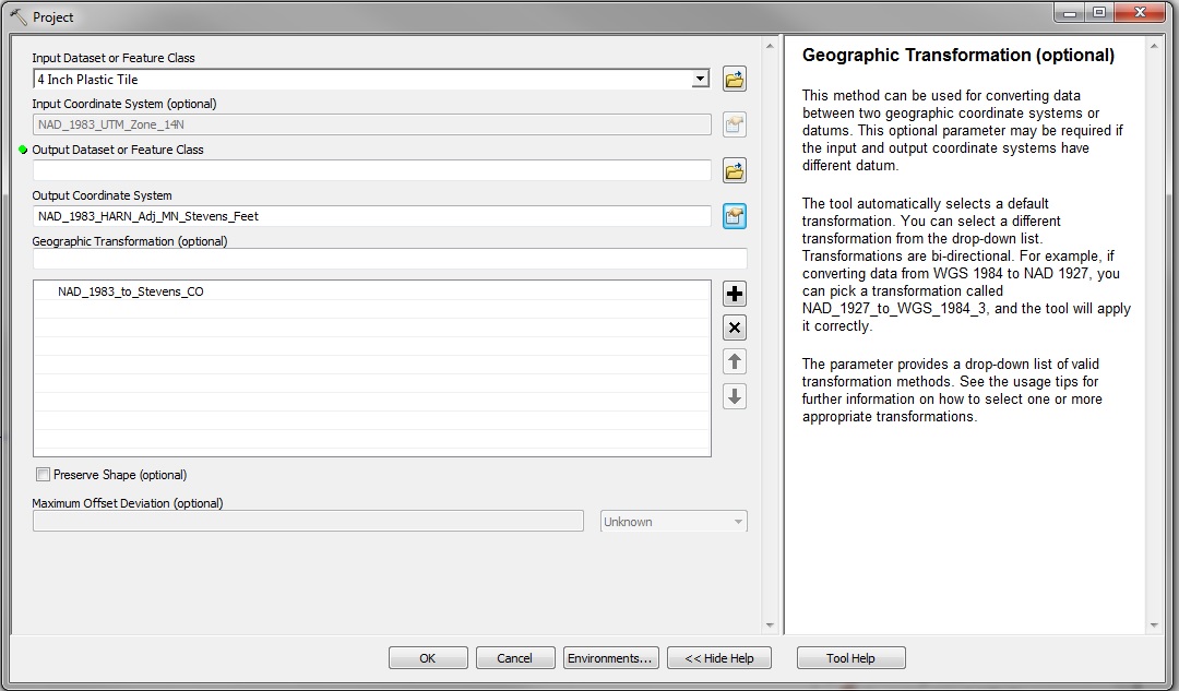
I got an unknown coordinate system layers called Outlet and Tile from someone. I then asked what their projection was suppose to be and it was NAD 1983 UTM Zone 14N so used the define projection tool for both of those layers. I then did the custom geographic transformation tool and did steps according to this 44021 - Transform between NAD 1983 and Minnesota County Coordinate Systems then I used the project tool to get it from NAD 1983 UTM 14N to NAD 1983 HARN Adj stevens feet and used the custom geographic transformation in place of the geographical transformation. Please refer to the picture below. Unless I am setting it up completely wrong. I don't think I got any errors it just wasn't lining up with our data.
- Mark as New
- Bookmark
- Subscribe
- Mute
- Subscribe to RSS Feed
- Permalink
How far off was your geographic data? Like, where did it put your stuff in relation to where it should have put your stuff?
- Mark as New
- Bookmark
- Subscribe
- Mute
- Subscribe to RSS Feed
- Permalink
Miles and miles. I couldn't see it in ArcMap
- Mark as New
- Bookmark
- Subscribe
- Mute
- Subscribe to RSS Feed
- Permalink
If that's the case, then it sounds like something needs to be done with the coordinate system. It seems that it's not matching up with the data. I would first toy around with the different coordinate systems in order to try to get it relatively close to where it needs to be. If it is that far off then sometimes you may need to look at UTM versus lat/long type of systems or maybe zone N versus zone S type of systems (depending on how far off it is). It sounds like this will take some testing to figure out, unfortunately.
- Mark as New
- Bookmark
- Subscribe
- Mute
- Subscribe to RSS Feed
- Permalink
Caitlin,
Can you post a sample coordinate pair from the original dataset (UTM)? If you add a basemap, does it look like it's overlaying correctly? Or if you change the data frame's display unit to decimal degrees, do they make sense?
Generally, if the output of a Project shows up in a weird place, the original data will too.
Melita