Iris Stewart-Frey, Santa Clara University
xCommunity xClimateChange xCollaboration xPPP xPublic Participation Planning x2014Talk xTalk xNicaragua xLatinAmerica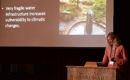
SCGIS Profile
2014 Conference Paper:
Local Knowledge Meets GIS in Assessing the Natural Resources for Nicaraguan Coffee-Growing Cooperatives
Presenter(s): Iris Stewart-Frey, Santa Clara University SESSION: Community Mapping and Public Participation GIS
"In Nicaragua, more than 50% of the rural residents live on the equivalent of less than $2/day; most of them are dependent on rain fed agriculture and local ecosystems, which have been subject to deforestation, biodiversity loss, and water contamination. Because of its geographical location and its political and ecological history, Nicaragua is a hot spot for climate change related risks and hazards, exacerbating threats to food insecurity. The work presented here investigates whether smallholders affiliated with cooperatives with more common property natural resources will have shorter periods of seasonal hunger and be more resilient to market and climatic shocks. We use a participatory process to estimate the availability of natural resources and understand management strategies that includes local knowledge and drawing of maps, joint (farmer—researcher) GPS-based data collection, surveys, and publicly available data sets (i.e., DEMs, forest cover)."