- Home
- :
- All Communities
- :
- Products
- :
- ArcPad (Retired)
- :
- ArcPad Questions
- :
- Post Processing GPS data: TxDOT vs. CORS
- Subscribe to RSS Feed
- Mark Topic as New
- Mark Topic as Read
- Float this Topic for Current User
- Bookmark
- Subscribe
- Mute
- Printer Friendly Page
- Mark as New
- Bookmark
- Subscribe
- Mute
- Subscribe to RSS Feed
- Permalink
Hello,
My apologies if this has been discussed in an earlier thread. I found similar threads, but none that answered my question.
I have collected GPS data using a Trimble GeoXH running ArcPad 10 with GPScorrect. I am still on ArcMap 10.0 and using GPS Analyst for post processing. My question is about choosing a base station for differential correction. In the differential correction wizard, there is a list of base stations to choose from. There are several base stations with a prefix of "CORS" and several base stations with a prefix of "TxDOT." For instance, there is a CORS Boerne station, and a TxDOT Boerne station. Could anyone explain the difference between these two? I believe these are the same base station (yes?). However, when I process my data against the CORS station, and then against the TxDOT station, the resulting points are 3 feet apart. I have looked at the data sheets from the CORS website for this station and it says that the coordinates are in NAD83 and ITRF00. So...which one is it? I was wondering if perhaps data corrected against the CORS base station is in ITRF00 and data corrected against the TxDOT base station is in NAD83?
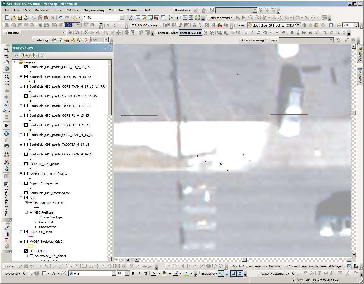
I have attached a picture of some of my gps data points. The pink dots were corrected against the CORS Boerne base station, and the yellow dots were corrected against the TxDOT Boerne base station. The pink and yellow dots are about 3 feet apart.
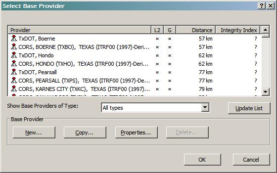
I have also attached a picture of the base station list from the differential correction wizard. Notice the top two stations in the list: TxDOT Boerne and CORS Boerne.
I have set up my personal geodatabase in State Plane, NAD83, and I have chosen the WGS84 to NAD83_5 translation. I understand that the raw GPS data from the .ssf file is in WGS84, and that is why a translation must be chosen. I'm just not sure if my final data (after post processing) is in NAD83 or ITRF00 (depending on which base station I use).
My goal is to end up with data that is in NAD83.
I hope this makes sense. Any help would be greatly appreciated.
Solved! Go to Solution.
Accepted Solutions
- Mark as New
- Bookmark
- Subscribe
- Mute
- Subscribe to RSS Feed
- Permalink
I believe you are in a NAD83 coordinate system from the settings you described. When you upload the unprocessed data from ArcPad to ArcMap, your data should still be in State Plane, NAD83 (uncorrected but still State Plane). Your Personal Database coordinate system is transferd from ArcMap- to ArcPad- then back to ArcMap. After post processing you will have corrected State Plane coordinate values. The WGS84/IRFT00 base stations are kind of a behind the scenes process that translates the raw GPS data (.ssf - WGS84) from your Trimble unit to another coordinate system. Assuming all project properties are set correctly.
Our set up from the Trimble GPS Analyst tab:
Personal Geodata base - Gnss enabled
GNSS enabled Feature classes spatial ref - NAD_1983_StatePlane_South_Dakota_South_FIPS_4002_Feet
GPS Analyst spatial ref - NAD_1983_StatePlane_South_Dakota_South_FIPS_4002_Feet
Geographic transformation - NAD_1983_To_WGS_1984_5
The attachments show what our ArcPad properties are after export from ArcMap.
The GPS prefernce needs to be set to D_WGS_1984. That is set in the ArcPad project, not from Arcmap like the Map properties and Datum Transformation are.
We then post process using the "Use reference positon from base providers" option. The base stations I use have the reference of ITRF00 in their properties also. After post processing the coordinates match (within a half a foot or so) of published survey monuments referenced to our state plane system, NAD83(Harn). According to this document http://store.elecdata.com/specsheets/55_ArcPad_Positions_Datum.pdf the _5 transformation puts the data into NAD83 (CORS96). I am unclear if I'm understanding that correctly or not.
Sorry for the long answer. I thought our setups were similar enough to share our process and results. Wish I could help understanding the shift in your data. Hope this helps. Todd
- Mark as New
- Bookmark
- Subscribe
- Mute
- Subscribe to RSS Feed
- Permalink
Not sure what happened to the attachments in my original post, but here they are now.
--Angela
- Mark as New
- Bookmark
- Subscribe
- Mute
- Subscribe to RSS Feed
- Permalink
Hi Angela,
I ran into data discrepancies like that when I post processed using the "Use reference position from base files" instead of the "from base providers" option in GPS Analyst. We also use a Trimble GeoXH running ArcPad 10 with GPScorrect/ArcMap 10. I believe the "from base providers" needs to be used when processing .ssf (wgs84) data. Using "from base files" causes a shift (I think we were off about 3 ft off too?). Has to do with the Trimble reciever collecting raw data in wgs84 and the base providers correcting this. I found these papers to be helpful with understanding some of that.
or
https://fpimgis.files.wordpress.com/2013/10/nad83-datum-transformation-issue.pdf
I noticed a similar situation with some base stations we use in Sioux Falls. The two top base stations (Sioux Falls) from the "base station" attachment look similar to yours. The provider properties show that each station occupies the same lat and long. Since the info in the "CORS, SIOUX COOP" provder has (new) at the end, and they occupy the same space maybe the old "COOP_CORS provider is no longer in service. But is still there in case old data needs to be processed against it? Perhaps your shifted data was processed from the old station using it's old "position from base files"?
On the CORS Map (http://www.ngs.noaa.gov/CORS_Map/) all I found was the CORS, BOERNE (TXBO) listed as station in your area. I found your two base stations in the Base Providers group of GPS Analyst and the latt and long match. Maybe the same thing is going on. Let me know and I can post process some data I have against the two Sioux Falls stations to see if I can replicate what is going on with your data. If you have any published survey control monuments close, you could collect and process those points, hopfully narrowing down what coordinate system you are in or want to be in.
BTW I am no expert with any of this software so my suggestions may not be very credible. Hope this helps and is not misleading. Todd
- Mark as New
- Bookmark
- Subscribe
- Mute
- Subscribe to RSS Feed
- Permalink
Hi Todd,
Thank you for your response. Yes, it seems that I am in the same boat as you. I'm not an expert at GPS data collection, but I am trying to figure this out.
I usually choose the "from base providers" option when post-processing. I still can't figure out the 3 foot shift between CORS and TxDOT. I always make sure that I use only TxDOT or only CORS base stations during a multiple station post-processing event. I don't want to mix the two because of that shift.
Yes, I am looking for some control monuments near me. I would like to test my data results.
So one final question:
If I choose a datum transformation (WGS84 to NAD83_5) when setting up my GPS geodatabase, and I post-process against a base station in ITRF00, am I correct in assuming that my final output data is in NAD83?
I know that my data takes on the datum of the base station, but I have chosen the transformation to NAD83 within ArcMap. I was never sure if that transformation occurred at the moment when I uploaded the unprocessed GPS data or after the data is processed and displayed again in ArcMap.
Anyhow, thank you again for your response. I have read the articles you attached and they were helpful.
- Mark as New
- Bookmark
- Subscribe
- Mute
- Subscribe to RSS Feed
- Permalink
I believe you are in a NAD83 coordinate system from the settings you described. When you upload the unprocessed data from ArcPad to ArcMap, your data should still be in State Plane, NAD83 (uncorrected but still State Plane). Your Personal Database coordinate system is transferd from ArcMap- to ArcPad- then back to ArcMap. After post processing you will have corrected State Plane coordinate values. The WGS84/IRFT00 base stations are kind of a behind the scenes process that translates the raw GPS data (.ssf - WGS84) from your Trimble unit to another coordinate system. Assuming all project properties are set correctly.
Our set up from the Trimble GPS Analyst tab:
Personal Geodata base - Gnss enabled
GNSS enabled Feature classes spatial ref - NAD_1983_StatePlane_South_Dakota_South_FIPS_4002_Feet
GPS Analyst spatial ref - NAD_1983_StatePlane_South_Dakota_South_FIPS_4002_Feet
Geographic transformation - NAD_1983_To_WGS_1984_5
The attachments show what our ArcPad properties are after export from ArcMap.
The GPS prefernce needs to be set to D_WGS_1984. That is set in the ArcPad project, not from Arcmap like the Map properties and Datum Transformation are.
We then post process using the "Use reference positon from base providers" option. The base stations I use have the reference of ITRF00 in their properties also. After post processing the coordinates match (within a half a foot or so) of published survey monuments referenced to our state plane system, NAD83(Harn). According to this document http://store.elecdata.com/specsheets/55_ArcPad_Positions_Datum.pdf the _5 transformation puts the data into NAD83 (CORS96). I am unclear if I'm understanding that correctly or not.
Sorry for the long answer. I thought our setups were similar enough to share our process and results. Wish I could help understanding the shift in your data. Hope this helps. Todd
- Mark as New
- Bookmark
- Subscribe
- Mute
- Subscribe to RSS Feed
- Permalink
Hi Todd,
Thank you so much for your response. You have confirmed what I thought. Since you are using the same set up and process as we are, I feel more confident in my procedure. After reading your response, I agree with you, and I do believe our final data is in the desired NAD83.
You have been a great help!
Thanks again,
Angela