Turn on suggestions
Auto-suggest helps you quickly narrow down your search results by suggesting possible matches as you type.
Cancel
- Home
- :
- All Communities
- :
- Developers
- :
- ArcObjects SDK (Retired)
- :
- ArcObjects SDK Questions
- :
- How to compute surface of raster or any point usin...
Options
- Subscribe to RSS Feed
- Mark Topic as New
- Mark Topic as Read
- Float this Topic for Current User
- Bookmark
- Subscribe
- Mute
- Printer Friendly Page
How to compute surface of raster or any point using ARCOBJECTS?
Subscribe
1029
1
02-24-2014 09:00 PM
02-24-2014
09:00 PM
- Mark as New
- Bookmark
- Subscribe
- Mute
- Subscribe to RSS Feed
- Permalink
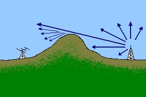
I have a raster image whose values are a digital elevation model of terrain.
I need to know the surface type (topographic characterization) of particular points along transects of this DEM.
How to find it?
(In my application I have two points: a transmitter end and receiver end. I find the highest point between the transmitter end and receiver end: see the figure below. I would like to know whether the highest point is smooth or is a knife edge; that is, to within the resolution of the image it appears to be non-differentiable.)[ATTACH=CONFIG]31719[/ATTACH]
1 Reply
02-26-2014
10:56 AM
- Mark as New
- Bookmark
- Subscribe
- Mute
- Subscribe to RSS Feed
- Permalink
This is an interesting problem but you actually have two questions, it seems to me.
1. how to determine if the high point between two point is smooth or sharp(?) Which really depends on how you distinguish either in terms of your wave diffraction equation. Seems like a directional slope change problem, 2nd polynomial or running slope tool twice.
2. how to do this in ArcObjects. You really can't tackle this until you'v answered question 1.