- Home
- :
- All Communities
- :
- Products
- :
- ArcMap (Retired)
- :
- ArcMap Questions
- :
- Reclassify (Spatial Analyst), failing to change cl...
- Subscribe to RSS Feed
- Mark Topic as New
- Mark Topic as Read
- Float this Topic for Current User
- Bookmark
- Subscribe
- Mute
- Printer Friendly Page
Reclassify (Spatial Analyst), failing to change classifications
- Mark as New
- Bookmark
- Subscribe
- Mute
- Subscribe to RSS Feed
- Permalink
Hi everyone, I don't know whats going wrong and was wondering if anyone would be able to help.
I am doing the habitat suitability analysis and using the GIS modules from my university as a guide. I have managed to complete it without any problems with the tutorial example but am encountering a problem using the real data.
I have created a euclidean distance file for a shapefile I made specifically for the analysis. (All files are georeferenced with the same system).
However, when I use the reclassify tool for the euclidean distance file, they just end up reverting to the default values. For example instead of 3 classes I end up with 9.
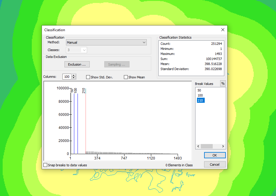
I have attached a few screenshots to demonstrate what's happening. You can see in screenshot 1 I have gone into classification on the reclassify tool, changed the classes to 3, method to manual and specified the break values as those needed for the model.
In screenshot 2 after I pressed ok the values have changed to the breaks I input, and I put the new values in as the scores for the model and press ok. However, when the tool runs, the values revert to their default scores as shown in screenshot 3.
I have no idea what's causing this error, if anyone has any idea I would really appreciate the help.
Solved! Go to Solution.
Accepted Solutions
- Mark as New
- Bookmark
- Subscribe
- Mute
- Subscribe to RSS Feed
- Permalink
You've not accounted for all values in the reclassification tool(i.e. those over 210). After applying the classified symbology then adding the raster layer into the reclassify tool, it should have shown all the ranges, it looks like you've manually adjusted the ranges?
Add a new range of 210 - 1493 to account for the rest of the data.
Also the bigger issue seems to be that looking at your histogram, you have no pixel values less than 210 in the first place - making the reclassification with those break values pointless.
- Mark as New
- Bookmark
- Subscribe
- Mute
- Subscribe to RSS Feed
- Permalink
Thanks, that solution worked! I had the pixels sorted out on other versions, and when I did it properly, this was my tenth time trying to work out what was going on and I literally just opened it up again to explain what was going on for the forum question. I have managed to do the analysis now though so thank you for the help!