- Home
- :
- All Communities
- :
- Products
- :
- ArcGIS Web AppBuilder
- :
- ArcGIS Web AppBuilder Questions
- :
- Situation Awareness Not Selecting Closest Feature?
- Subscribe to RSS Feed
- Mark Topic as New
- Mark Topic as Read
- Float this Topic for Current User
- Bookmark
- Subscribe
- Mute
- Printer Friendly Page
Situation Awareness Not Selecting Closest Feature?
- Mark as New
- Bookmark
- Subscribe
- Mute
- Subscribe to RSS Feed
- Permalink
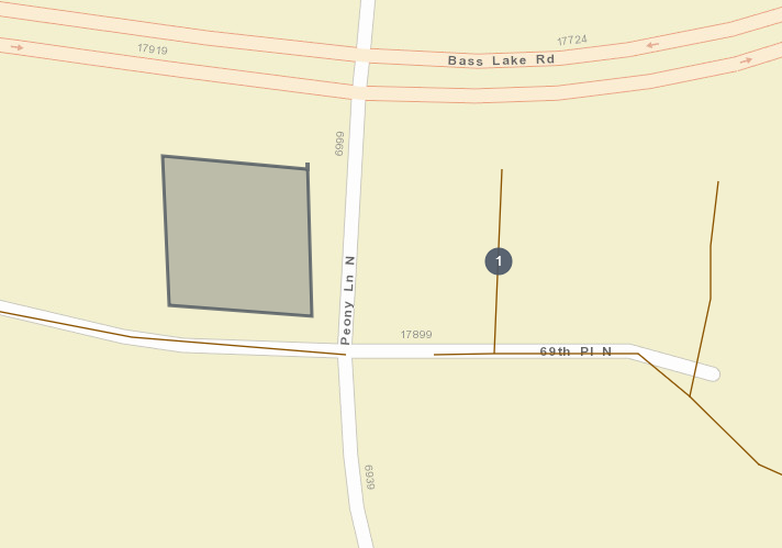
This screenshot should say it all... basically, the Situation Awareness Widget is not selecting the closest feature. In the screenshot I drew a box and it is telling me that the closest line to the box is the one with the "1" on it. This is not correct, and it is consistently giving me incorrect results. Anybody else experiencing this?

- Mark as New
- Bookmark
- Subscribe
- Mute
- Subscribe to RSS Feed
- Permalink
Hi Derrick Frese,
I had a similar issue to what you are experiencing and did some troubleshooting. It appears that the reason the Situational Awareness widget appears to return incorrect closest features for polylines is because it calculates distance based off either the center point of the line or the centroid of the minimum bounding box around the full extent of the line, rather than the nearest end point or vertices.
This is based purely off my own anecdotal evidence and experimentation as I wasn't able to find a solid answer or reason for this problem. I feel there may be some underlying issue with the Situational Awareness Widget as when i click on some of the selected features returned within a buffer distance, the pop-ups for some layers will incorrectly display information relating to another layer that either isn't even turned on in the layers menu and that isn't referenced by the widget itself.
Hopefully that may answer your question.
Thanks,
- Mark as New
- Bookmark
- Subscribe
- Mute
- Subscribe to RSS Feed
- Permalink
Joe:
Have you ever tested the Situational Awareness Widget with polygons features? I was also getting what I thought was incorrect results, but your explanation then made me think that the Situational Awareness Widget was using the polygon centroid to determine the closest feature. Your reasoning would explain why when I click right next to a feature with an odd shape the widget selects a feature much further from the point, but it's centroid is probably closer.
Would you know whether this is the case as the Situational Awareness Widget does not mention whether it uses any part of a polygon shape for analysis or it uses the centroid of the polygon (The results would indicate that the centroid is being used, but I would like confirmation of this)?
- Mark as New
- Bookmark
- Subscribe
- Mute
- Subscribe to RSS Feed
- Permalink
I totally wish this widget would not search for the polygon centroid. It should read 'closest center' instead of 'closest' in the Analysis Type. I almost feel that the development team should take a long hard look at this and think, then re-think, this is an easy spatial concept that should be provided in this widget.
- Mark as New
- Bookmark
- Subscribe
- Mute
- Subscribe to RSS Feed
- Permalink
I've also been experiencing issues with the situation awareness widget interacting with polygon features. When using the Proximity analysis type, the widget will locate the polygon centroids within the buffer. But when using the Summary analysis type, the output returns a "No features found" message. Is there a way to generate of summary of attributes for a given area base on a polygon feature layer?