- Home
- :
- All Communities
- :
- Products
- :
- ArcGIS Web AppBuilder
- :
- ArcGIS Web AppBuilder Ideas
- :
- ArcGIS Web AppBuilder : Screening widget reporting...
- Subscribe to RSS Feed
- Mark as New
- Mark as Read
- Bookmark
- Follow this Idea
- Printer Friendly Page
ArcGIS Web AppBuilder : Screening widget reporting capability, feature selection enhancement
- Mark as New
- Bookmark
- Subscribe
- Mute
- Subscribe to RSS Feed
- Permalink
This issue is being logged on behalf of City of Marion, in the state of South Australia.
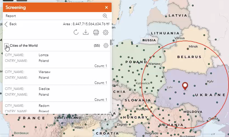
The Screening widget allows reporting of features in designated feature layer(s), based on certain criteria.
For example, report attributes for all features from designated feature layers, that lie within 1 kilometre of a drawn point. The "report" is displayed on-screen, within the Screening widget form : as shown in attached : screenWidgetReportEg.png.
It is possible to interactively select each row in the report, and consequently see its corresponding feature highlight (in the map's selection colour) on the map, as shown in screenWidgetReportSelectRow.png.
User would like an additional capability where :
a. An extra button exists on the reporting form that will highlight (ie. display in the map's selection colour) all of the features that are included in the report;
b. Multiple rows can be successively clicked on the report, and they will be successively highlighted (ie. displayed in the map's selection colour) on the map, effectively adding to the displayed selection set; Successive clicks on the one report record will toggle selection/deselection of that feature, on the map, and in the report.
The above capability will allow the Screening widget to create an even more useful information product, as a consequence of its use. - That is, the display is able to spatially highlight subsets of reported records, something that the user feels is lacking in the present capabilities of the Screening widget.
I have successfully added this widget to our applications and really enjoy it. However, I too would like it if the results were highlighted on the map to show users that indeed, it selected the expected features.

This is a great request Allison,
At Naracoorte Lucindale Council we use the Isolink widget that allows direct to SQL queries on our internal mapping system to enable our cadastre data/asset data to be live and not updated via scripting. The selection of multiple items in the list produced by the Isolink widget remain highlighted on the map and even zooms to a feature when selected.
BUT- as yet we have never found a way for this widgets data to generate a report, or link it to the screening widget.
If ESRI were able to bridge the gap between the functionality of the Isolink widget that ESRI now offers directly in Australia - and the reporting abilities of the screening widget with Allison's requested functionality then a huge multi year gap in ESRIs post Decco connectivity issues would be resolved.
You must be a registered user to add a comment. If you've already registered, sign in. Otherwise, register and sign in.