- Home
- :
- All Communities
- :
- Products
- :
- ArcGIS Survey123
- :
- ArcGIS Survey123 Questions
- :
- Issues working with Survey123
- Subscribe to RSS Feed
- Mark Topic as New
- Mark Topic as Read
- Float this Topic for Current User
- Bookmark
- Subscribe
- Mute
- Printer Friendly Page
Issues working with Survey123
- Mark as New
- Bookmark
- Subscribe
- Mute
- Subscribe to RSS Feed
- Permalink
Hello,
I'm trying to build a simple form for folks to report issues, such as potholes, street light out etc.
One of the key things I wanted was for the geopoint map, where the user selects the issue location, to show the already existing features (previously entered survey form locations) in order to show that something was already reported or resolved. This didn't seem possible using the web designer so I started with the desktop (Connect) application using an existing feature service.
Here are the issues I am seeing:
- Using Connect still doesn't show the existing features on the map
- Connect does not offer the same options as the web configurator. Such as
- The geopoint question doesn't show the actual map preview at all. You have to hit a button first
- The geopoint map does not seem to allow it to default to the users current location
- "Allow the respondent to add another record" doesn't seem to exist and if I try to add that using the web configurator after creating in Connect, it simply doesn't save it that way.
So Connect just seems to not have as much functionality in this way so I suppose I will stick with the web configurator but I'm still left with how to display the existing features on the map.
Any suggestions on how to remedy this?
Thanks!
- Mark as New
- Bookmark
- Subscribe
- Mute
- Subscribe to RSS Feed
- Permalink
Hi Eric,
It it not currently possible to display existing features on the geopoint location map in Survey123 Connect or Web Designer, and hence they can not be displayed in the Feild App or Web App when uses views the geopoint location map. We have an open enhancement for this request already, which will allow displaying web maps with existing data and other types of tile and map packages, which would support displaying existing features in the geopoint map.
As for the map and your location being automatically displayed on the map, yes this is supported, and provided you have accepted that the web app (in a browser) or the field app (device settings) as access to allow location services, your location will be automatically obtained, and the default basemap will be loaded. Note for the field app you need to be online, or use an offline basemap pre-loaded on the device.
Currently using the Inbox map view, you can see other existing features that exist int he feature layer, before you launch the survey for an existing point.
Phil.
- Mark as New
- Bookmark
- Subscribe
- Mute
- Subscribe to RSS Feed
- Permalink
I am opening the survey via the browser on my phone. Not the app. The url is allowed to access the gps.
When using the geopoint, I can get my location by clicking the location button fine, it just does not default to my location. I see no setting anywhere in Connect that would allow that. Can you assist?
Also, when building via the web, the geopoint starts as a preview map, which is desired, but starting via Connect only shows a button. Can that be adjusted?
Why do these differences exist between the two?
Thanks
- Mark as New
- Bookmark
- Subscribe
- Mute
- Subscribe to RSS Feed
- Permalink
Hi Philip,
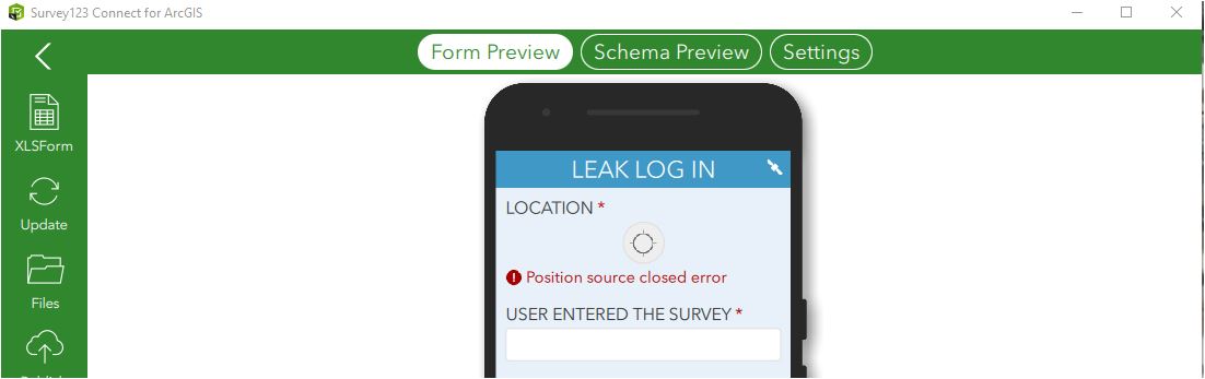
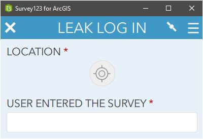
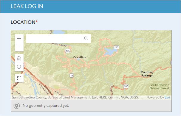
I having the same similar or same issue...all images are from the same survey service
Survey 123 connect sample
survey 123 field app for desktop sample same as survey 123 field app mobile
Survey 123 web sample
- Mark as New
- Bookmark
- Subscribe
- Mute
- Subscribe to RSS Feed
- Permalink
Hi Ismael,
It appears you are using Survey123 Connect and field app on Windows on your desktop/laptop, however I see you have a "position source closed" error. This means that Survey123 does not have access to location services on your desktop/laptop so is unable to get a valid location. You need to ensure your desktop/laptop has location services enabled (via GPS/Wifi/4G) and that it is getting a current location, so that Survey123 can use this location.
As for the map not displaying, are you using the default basemap, or have you set a new basemap via Connect? Is your device online and connected to internet, so that it has access to online basemap services, or are you trying to offline basemaps? The map will only display in preview and detailed view if you are online (for online services) or if you have loaded offline basemaps and take your device offline.
The behaviour by default of Connect, field app and web app is the same from a loading and displaying preview map with default basemap, provided the device has a valid location and can access the default basemap (online or offline).
Phil.