- Home
- :
- All Communities
- :
- Products
- :
- ArcGIS Survey123
- :
- ArcGIS Survey123 Questions
- :
- Re: How to prepopulate geopoint from URL Scheme X ...
- Subscribe to RSS Feed
- Mark Topic as New
- Mark Topic as Read
- Float this Topic for Current User
- Bookmark
- Subscribe
- Mute
- Printer Friendly Page
How to prepopulate geopoint from URL Scheme X & Y
- Mark as New
- Bookmark
- Subscribe
- Mute
- Subscribe to RSS Feed
- Permalink
Good evening everyone,
I have queried the GeoNet and have not come across the workflow on utilizing Lat Long from a feature service within Collector with a URL scheme. I can push the values across to my survey but I do not know how to have the 'geopoint' default to them.
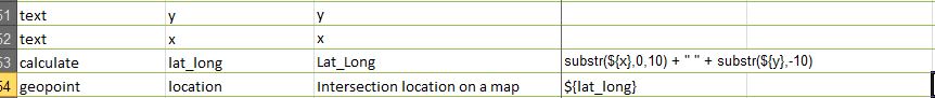
This is an example of my xlsx form showing Y and X coming across and then combining. Before sending to the geopoint.
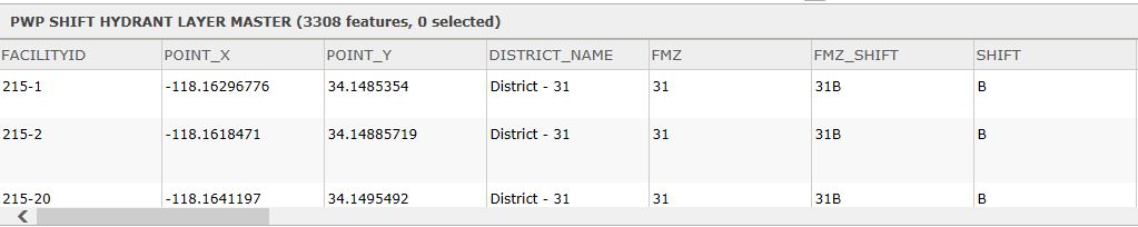
This is the actual table from the hydrant feature service. I utilize the FacilityID as my unique ID and also bring across the FMZ and Shift.
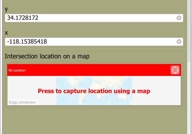
This is currently my result.
Again any information would be helpful. TX
Solved! Go to Solution.
Accepted Solutions
- Mark as New
- Bookmark
- Subscribe
- Mute
- Subscribe to RSS Feed
- Permalink
Hi Oscar,
I'm not quite sure what you're meaning by "lat/long defined in the URL not generic lat/long will produce an overlay on the existing point within collector" - if the Point_X and Point_Y are the same as the lat/long of the shape, they will still overlay.
With regard to this in your case, the url should have
center={Point_Y},{Point_X}
in the link in the popup
- Mark as New
- Bookmark
- Subscribe
- Mute
- Subscribe to RSS Feed
- Permalink
Something like this should do the trick:
| type | name | label | calculation |
| text | x | X | |
| text | y | Y | |
| geopoint | location | Location | ${x} + " " + ${y} |
You don't need to use substr() in this case because the X and Y values are already in separate fields - you just need to concatenate the values.
- Mark as New
- Bookmark
- Subscribe
- Mute
- Subscribe to RSS Feed
- Permalink
You should also be able to specify the point with the 'center' parameter, as per Integrate with other apps—Survey123 for ArcGIS | ArcGIS :
arcgis-survey123://?itemID=36ff9e8c13e042a58cfce4ad87f55d19&field:Surname=Klauser¢er=37.8199,-122.4783
- Mark as New
- Bookmark
- Subscribe
- Mute
- Subscribe to RSS Feed
- Permalink
Hi James Tedrick ,
I saw Integrate with other apps—Survey123 for ArcGIS | ArcGIS yet I am confused on how the use of 'center=' with the lat/long defined in the URL not generic lat/long will produce an overlay on the existing point within collector.
Can you please help me understand this? Thank you.
- Mark as New
- Bookmark
- Subscribe
- Mute
- Subscribe to RSS Feed
- Permalink
Hi Oscar,
I'm not quite sure what you're meaning by "lat/long defined in the URL not generic lat/long will produce an overlay on the existing point within collector" - if the Point_X and Point_Y are the same as the lat/long of the shape, they will still overlay.
With regard to this in your case, the url should have
center={Point_Y},{Point_X}
in the link in the popup
- Mark as New
- Bookmark
- Subscribe
- Mute
- Subscribe to RSS Feed
- Permalink
Ok. Thank you James Tedrick ![]() . I was literally putting in 37.8199,-122.4783 instead of ={Point_Y},{Point_X} . Now it works perfectly!
. I was literally putting in 37.8199,-122.4783 instead of ={Point_Y},{Point_X} . Now it works perfectly!