Turn on suggestions
Auto-suggest helps you quickly narrow down your search results by suggesting possible matches as you type.
Cancel
- Home
- :
- All Communities
- :
- Products
- :
- ArcGIS StreetMap Premium
- :
- ArcGIS StreetMap Premium Questions
- :
- Tabulate Area help
Options
- Subscribe to RSS Feed
- Mark Topic as New
- Mark Topic as Read
- Float this Topic for Current User
- Bookmark
- Subscribe
- Mute
- Printer Friendly Page
Tabulate Area help
Subscribe
6769
5
05-21-2014 05:12 PM
by
Anonymous User
Not applicable
05-21-2014
05:12 PM
- Mark as New
- Bookmark
- Subscribe
- Mute
- Subscribe to RSS Feed
- Permalink
Original User: infadork
I am trying to tabulate area of a Land Use and Local Watershed, however when I put in the Local Watershed into the first input their is no option for Area, which I have in the table of the Local Watershed attributes. How do I go about accessing that data to tabulate the area?
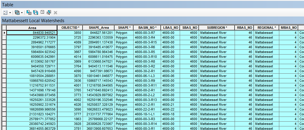
The first picture is my attribute table which clearly shows Area as a column.
[ATTACH=CONFIG]33985[/ATTACH]
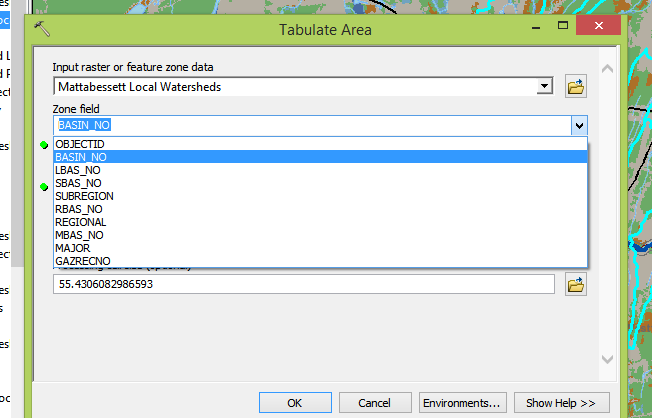
This second picture are my selectable attributes when under Tabulated Area.
[ATTACH=CONFIG]33984[/ATTACH]
How do I get the Area under the selectable attributes?
I am trying to tabulate area of a Land Use and Local Watershed, however when I put in the Local Watershed into the first input their is no option for Area, which I have in the table of the Local Watershed attributes. How do I go about accessing that data to tabulate the area?
The first picture is my attribute table which clearly shows Area as a column.
[ATTACH=CONFIG]33985[/ATTACH]
This second picture are my selectable attributes when under Tabulated Area.
[ATTACH=CONFIG]33984[/ATTACH]
How do I get the Area under the selectable attributes?
5 Replies
by
Anonymous User
Not applicable
05-21-2014
06:59 PM
- Mark as New
- Bookmark
- Subscribe
- Mute
- Subscribe to RSS Feed
- Permalink
Original User: raymondhuang
Hi Adam,
The tool helps you tabulate the area based on your zones and produces a table out of it. Not sure if it is what you are expecting from the tool:
See here for more info: http://help.arcgis.com/en/arcgisdesktop/10.0/help/index.html#//009z000000w2000000.htm
For your datasets, may I check if you are trying to find out the different types of landuse and their respective areas inside a watershed? Also, are your Landuse and Watershed datasets both rasters?
Hope those are correct guiding questions to help in your case. Let us know how it goes.
Regards,
Raymond
05-21-2014
07:07 PM
- Mark as New
- Bookmark
- Subscribe
- Mute
- Subscribe to RSS Feed
- Permalink
Raymond,
Pleased to see you again lol.
I looked on the forums and I found a way to calculate Percentage Land Use: http://forums.arcgis.com/threads/70779-arcmap-land-use-type-as-a-percentage-of-total-area
I am trying to find out the different percentages of land use within each local watershed. It is from there that I will be basing where I will sample water from along the river.
I have honestly no idea if both sets of data are rasters or not, but I would imagine the Land use is a raster and the watershed is not, but I could be wrong.
Anything else I can put in there to help you out?
by
Anonymous User
Not applicable
05-21-2014
07:20 PM
- Mark as New
- Bookmark
- Subscribe
- Mute
- Subscribe to RSS Feed
- Permalink
Original User: raymondhuang
Hi Adam,
Haha, nice to be 'chatting' again.
When, will it be convenient for you to post one or two screenshots of ArcMap showing your Table of Contents and the Catalog panel showing where your data is from?
Raymond
Hi Adam,
Haha, nice to be 'chatting' again.
When, will it be convenient for you to post one or two screenshots of ArcMap showing your Table of Contents and the Catalog panel showing where your data is from?
Raymond
05-21-2014
07:28 PM
- Mark as New
- Bookmark
- Subscribe
- Mute
- Subscribe to RSS Feed
- Permalink
How about now?
[ATTACH=CONFIG]33986[/ATTACH]
I know I downloaded all of the appropriate geodatabase information from the following websites:
http://magic.lib.uconn.edu/connecticut_data.html and http://www.ct.gov/deep/cwp/view.asp?A=2698&Q=322898
[ATTACH=CONFIG]33986[/ATTACH]
I know I downloaded all of the appropriate geodatabase information from the following websites:
http://magic.lib.uconn.edu/connecticut_data.html and http://www.ct.gov/deep/cwp/view.asp?A=2698&Q=322898
by
Anonymous User
Not applicable
05-29-2014
02:15 PM
- Mark as New
- Bookmark
- Subscribe
- Mute
- Subscribe to RSS Feed
- Permalink
Original User: infadork
Raymond,
Any word? I am seriously stuck ugh...
Raymond,
Any word? I am seriously stuck ugh...