- Home
- :
- All Communities
- :
- Products
- :
- ArcGIS Spatial Analyst
- :
- ArcGIS Spatial Analyst Questions
- :
- Tabulate Area Error
- Subscribe to RSS Feed
- Mark Topic as New
- Mark Topic as Read
- Float this Topic for Current User
- Bookmark
- Subscribe
- Mute
- Printer Friendly Page
Tabulate Area Error
- Mark as New
- Bookmark
- Subscribe
- Mute
- Subscribe to RSS Feed
- Permalink
I asked this question yesterday, but I accidently marked it as sloved. I still need suggestions or solution to this problem. I post it again and see if anyone could be of help. Thank you!
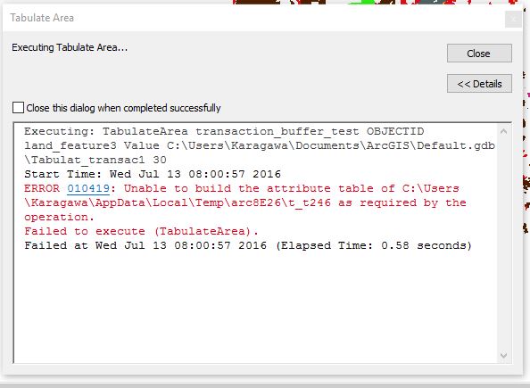
I tried to run Tabulate Area(Zonal Analysis), but the ArcMap fails to run this tool and any other tools in Zonal Analysis package. It reports errors as the picture shows:
I tried to build the attribute table for the raster layer by myself, but it still does not work out. I am using ArcMap 10.3. I use the exactly same data on another computer, the zonal analysis runs well. Really frustrated about this. Anyone could help me to figure out whats wrong here? Please let me know if you need any other information. Many Thanks!
- Mark as New
- Bookmark
- Subscribe
- Mute
- Subscribe to RSS Feed
- Permalink
Could you store the data to a path with shorter pathname (e.g. C:Project/Raster/image1.tif)?
In case the issue still persists, try building Raster Attribute Table using the following tool.
Think Location
- Mark as New
- Bookmark
- Subscribe
- Mute
- Subscribe to RSS Feed
- Permalink
Hi, Jayanta:
Thanks for your suggestion. I tried the short name suggestion. It still does not work. Seems like the Tabulate Area Function can't convert the feature to rater internally!
- Mark as New
- Bookmark
- Subscribe
- Mute
- Subscribe to RSS Feed
- Permalink
did you follow instructions here Tabulate Area—Help | ArcGIS for Desktop
is you did, is your zone layer an integer raster or a featureclass or shapefile? If a featureclass you should really convert it to an integer raster with the same cell size, extent and use it as the snap raster
Working with Tabulate Area—Help | ArcGIS for Desktop so you don't rely on vector raster conversion.
You have confirmed that the zonal layer and data layer both are in the same coordinate system
Can you confirm that you have built the raster attribute table
Build Raster Attribute Table—Help | ArcGIS for Desktop
Raster dataset attribute tables—Help | ArcGIS for Desktop and had a look at it
I may have missed a step, so you might want to fill in any gaps, such as file path, arcmap version etc etc
- Mark as New
- Bookmark
- Subscribe
- Mute
- Subscribe to RSS Feed
- Permalink
Hi, Dan:
Thank you very much for your reply. I tried all your suggestions. I find out that if I convert the input feature-class into raster manually first and input both raster layers into the tabulate area function. It works!
However, I think the root of problem here is the tabulate function can't perform the internal conversion (i.e., feature to raster) for me. I read all of the instruction and believe that if I input a feature class, the tabulate function can make the conversion for me internally. I think the data is fine since those data can be run by Tabulate Area function on another computer perfectly. Just wondering what's the reason my computer can't run this function properly. Is there any bugs or software conflicts could lead to the failure of Tabulate Area function?
Again, thank you for your suggestions!
- Mark as New
- Bookmark
- Subscribe
- Mute
- Subscribe to RSS Feed
- Permalink
for what its worth... doing it manually is THE correct way, because it doesn't try to help you by determining what is a potentially inappropriate cell size, extent and file name. When you do it manually, you are in control and have no one else to blame but yourself. Sometimes, tools shouldn't enable sloppy data management practices because they are just trying to be helpful, the downside is, people would find the tool less user friendly... until things go wrong.
So ....
- keep doing things manually,
- don't rely on defaults,
- check the Environments tab for every tool for every run
- I won't go off on filenames and filepaths... that has been the discussion of several blog posts