- Home
- :
- All Communities
- :
- Products
- :
- ArcGIS Spatial Analyst
- :
- ArcGIS Spatial Analyst Questions
- :
- Need help with idw
- Subscribe to RSS Feed
- Mark Topic as New
- Mark Topic as Read
- Float this Topic for Current User
- Bookmark
- Subscribe
- Mute
- Printer Friendly Page
Need help with idw
- Mark as New
- Bookmark
- Subscribe
- Mute
- Subscribe to RSS Feed
- Permalink
the question is asking for the raster value at the intersection of 4 raster cells? Not your fault at all, but that confuses me no end.
- Mark as New
- Bookmark
- Subscribe
- Mute
- Subscribe to RSS Feed
- Permalink
I believe so. I have no idea what points to use or how to find the distance with the things given .
- Mark as New
- Bookmark
- Subscribe
- Mute
- Subscribe to RSS Feed
- Permalink
I think @DanPatterson can offer some academic input on this one.
- Mark as New
- Bookmark
- Subscribe
- Mute
- Subscribe to RSS Feed
- Permalink
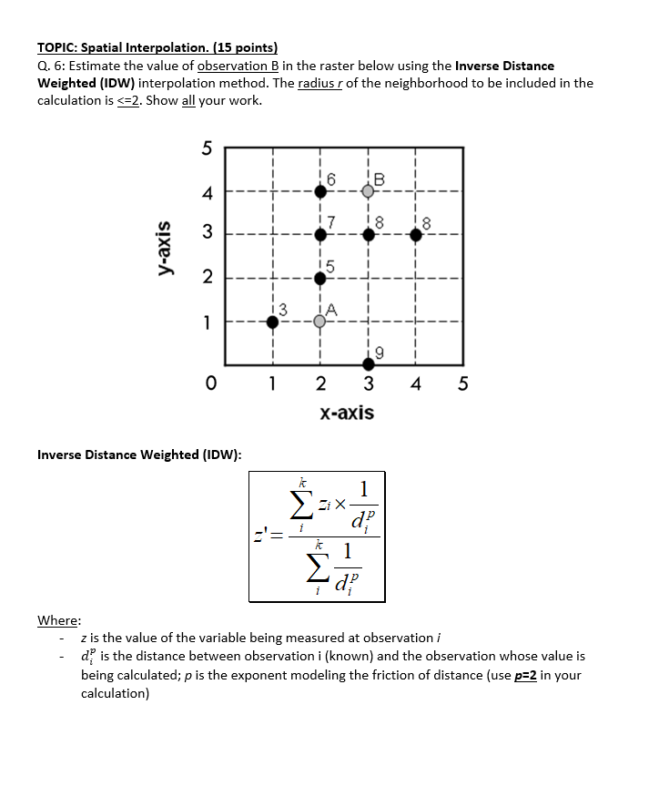
That is merely a cartesian plot of the points, not raster cells.
The x and y axis show spacings of 1 unit for distance, so for a horizontal or vertical movement you are moving 1 distance unit. a diagonal movement would represent sqrt(2) (pythagorean theorem).
You must decide which points to include given that the distance values must be <= 2.
Pick the points to include and use the equation to sum the distance values etc...
Since it is a problem presumably for a course, I will leave the solution to you... make sure you show your work.
... sort of retired...
- Mark as New
- Bookmark
- Subscribe
- Mute
- Subscribe to RSS Feed
- Permalink
Interactive Geostatistical Wizard is also a great teaching tool. I've hidden the answer as this is an assignment 😀

- Mark as New
- Bookmark
- Subscribe
- Mute
- Subscribe to RSS Feed
- Permalink

did I do this correctly?
- Mark as New
- Bookmark
- Subscribe
- Mute
- Subscribe to RSS Feed
- Permalink
Sorry... I stopped grading assignments when I retired 😉
... sort of retired...