Turn on suggestions
Auto-suggest helps you quickly narrow down your search results by suggesting possible matches as you type.
Cancel
- Home
- :
- All Communities
- :
- Products
- :
- ArcGIS Spatial Analyst
- :
- ArcGIS Spatial Analyst Questions
- :
- How do you create a Point Shapefile at a known XY ...
Options
- Subscribe to RSS Feed
- Mark Topic as New
- Mark Topic as Read
- Float this Topic for Current User
- Bookmark
- Subscribe
- Mute
- Printer Friendly Page
How do you create a Point Shapefile at a known XY location in python (ArcGIS)?
Subscribe
2260
4
07-31-2017 02:12 PM
07-31-2017
02:12 PM
- Mark as New
- Bookmark
- Subscribe
- Mute
- Subscribe to RSS Feed
- Permalink
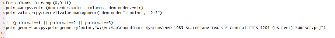
I am currently writing a python program that is scanning cells in a raster. If the program passes an if statement then I want to put a point file at that exact xy location it scanned. What is the function that inserts a shapefile at a specific xy location?
4 Replies
07-31-2017
02:42 PM
- Mark as New
- Bookmark
- Subscribe
- Mute
- Subscribe to RSS Feed
- Permalink
You would need to create the geometry first, then the featureclass or shapefile. Start by examining the arcpy functions etc and specifically the code example in the PointGeometry class linked here
08-01-2017
06:59 AM
- Mark as New
- Bookmark
- Subscribe
- Mute
- Subscribe to RSS Feed
- Permalink
what is the function that converts the point geometry into a feature class?
08-01-2017
10:49 AM
- Mark as New
- Bookmark
- Subscribe
- Mute
- Subscribe to RSS Feed
- Permalink
the last line int he link I posted
arcpy.CopyFeatures_management(pointGeometryList, "c:/geometry/a.gdb/points")
08-01-2017
02:28 PM
- Mark as New
- Bookmark
- Subscribe
- Mute
- Subscribe to RSS Feed
- Permalink
In one of your other threads... Copy Features was recommended. Posting in one location makes it easier for people to keep track of a question and its incarnations.