- Home
- :
- All Communities
- :
- Products
- :
- ArcGIS Spatial Analyst
- :
- ArcGIS Spatial Analyst Questions
- :
- Re: Euclidean Distance on polygon shapefile giving...
- Subscribe to RSS Feed
- Mark Topic as New
- Mark Topic as Read
- Float this Topic for Current User
- Bookmark
- Subscribe
- Mute
- Printer Friendly Page
Euclidean Distance on polygon shapefile giving errors with default values
- Mark as New
- Bookmark
- Subscribe
- Mute
- Subscribe to RSS Feed
- Permalink
Hi,
I have ArcMap 10.3 and it is up to date. I have the following in an .mxd:
- "State" layer of California - one polygon with a handful of attributes
- "Protected Areas" layer - one polygon for protected land from USGS which I dissolved all boundaries
- "Elevation" layer - DEM raster from USGS
My Environment is set to the following:
- Output Coordinate System = Same as Display
- Processing Extent = Same as Layer State
- Raster Analysis Settings
- Cell Size = Same as elevation
Mask = State
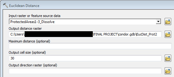
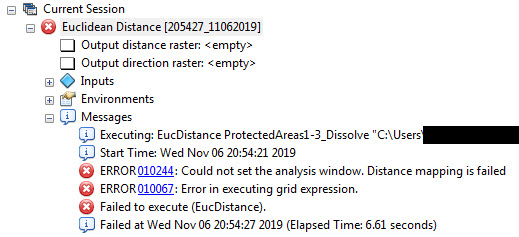
Attached is the map of California with the Protected Areas layer, my Euclidean Distance dialog box and the error.
I'm trying to run Euclidean Distance from Spatial Analyst (it is turned on) but I'm getting errors and I don't know why. I tried different Maximum Distances and Output Cell Sizes but didn't touch Output Direction (didn't see how that could help). When Output Cell Size was set to 5 and 1, I just got big blocks of color. When I used the default Output Cell Size 30 and any higher numbers, I got nothing on the map and the error (see attached).
I also tried running Euclidean Distance on the "Protected Areas" layer that didn't have dissolved boundaries (4200+ polygons) and ArcMap gave the same error.
What I'd like is the Euclidean Distance to return a result and have the bands of color be pretty narrow because there's lots of little patches of protected land. Any help would be appreciated! Many thanks in advance.
\Frances
- Mark as New
- Bookmark
- Subscribe
- Mute
- Subscribe to RSS Feed
- Permalink
Hi Neil,
My state layer is GCS_WGS_1984 but both my elevation and Protected Areas layer is GCS_NorthAmerican_1983. I thought that since ArcMap convert on the fly that it would be okay? Does this mean I find a state layer in GCS_NorthAmerican_1983 to make Euclidean Distance work?
Thanks.
- Mark as New
- Bookmark
- Subscribe
- Mute
- Subscribe to RSS Feed
- Permalink
Hi Neil,
I changed my state layer from "GCS_WGS_1984" to "GCS_North_American_1983" to match the GCS on the Protected Areas and elevation layers and the Euclidean Distance function worked.
Both the Protected Areas and elevation layers had projections. The state layer didn't have a projection but it didn't seem to matter.
Thanks for your help! My project is moving along again!