- Home
- :
- All Communities
- :
- Products
- :
- ArcGIS Spatial Analyst
- :
- ArcGIS Spatial Analyst Questions
- :
- Calculate multiple shapefiles inside of other shap...
- Subscribe to RSS Feed
- Mark Topic as New
- Mark Topic as Read
- Float this Topic for Current User
- Bookmark
- Subscribe
- Mute
- Printer Friendly Page
Calculate multiple shapefiles inside of other shapefiles for area
- Mark as New
- Bookmark
- Subscribe
- Mute
- Subscribe to RSS Feed
- Permalink
Hello,
I am wondering if there is anyway to combine shapefiles (or calculate or join) to a layer of different shapefiles to calculate total area inside of them.
For example, I have a buildings footprint layer which has company name and other building information in each shapefile (black outlined polygons in image). I have calculated suitable locations for solar panels on the rooftop(pink color in image) which has the calculated area and would like to calculate the total solar panel potential for each building footprint shapefile.
I was thinking something along the lines of somehow grouping the solar shapefiles that are inside each building shapefile and combining them and calculating total area. Then possibly calculating a new row in the attribute table of the building shapefiles so I can display that in color coordination.
Any help would be great, thanks in advance!!!
Solved! Go to Solution.
Accepted Solutions
- Mark as New
- Bookmark
- Subscribe
- Mute
- Subscribe to RSS Feed
- Permalink
The Summarize Within GP tool should do this for you. Do take a look at Summarize Within—Help | ArcGIS Desktop
You should be able to use a building name or number (if you have one, or anything similar) if you want to calculate the extent of solar panels for each building as well, just make sure to use the Group Field option. You can then link the output table back to building layer if needed.
- Mark as New
- Bookmark
- Subscribe
- Mute
- Subscribe to RSS Feed
- Permalink
Thank you so much for your reply. Unfortunately, I do not have this tool on the license that I have. Do you know if it only works for Arc Pro? I tried looking for this answer but couldnt find a straight forward answer. Thanks!!!
- Mark as New
- Bookmark
- Subscribe
- Mute
- Subscribe to RSS Feed
- Permalink
What license do you have? ArcGIS Desktop Advanced? Tabulate Intersection requires the advanced license and can do the same thing.
But if you have a Basic license, then you may need to do this in a few steps: (1) an Intersection, then (2) use Summary Statistics to extract the statistics you require.
You could optionally Calculate Geometry between steps 1 and 2 if you are not saving to a geodatabase.
- Mark as New
- Bookmark
- Subscribe
- Mute
- Subscribe to RSS Feed
- Permalink
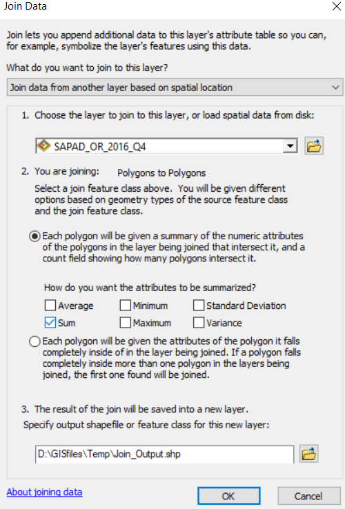
You could also try a Spatial Join, with the option to summarise the attributes from your solar panels (see below screenshot). You will need to right-click on your Buildings layers and then select Joins and Relates > Joins...
- Mark as New
- Bookmark
- Subscribe
- Mute
- Subscribe to RSS Feed
- Permalink
Thanks for your replies! I had a buddy lend me her login to ArcGIS Pro and the Summarize Within worked perfectly! I appreciate your advice.
- Mark as New
- Bookmark
- Subscribe
- Mute
- Subscribe to RSS Feed
- Permalink
Pleasure