- Home
- :
- All Communities
- :
- Products
- :
- ArcGIS Pro
- :
- ArcGIS Pro Questions
- :
- Why is the XY Table To Point tool confusing the in...
- Subscribe to RSS Feed
- Mark Topic as New
- Mark Topic as Read
- Float this Topic for Current User
- Bookmark
- Subscribe
- Mute
- Printer Friendly Page
Why is the XY Table To Point tool confusing the input and output coordinate systems?
- Mark as New
- Bookmark
- Subscribe
- Mute
- Subscribe to RSS Feed
- Permalink
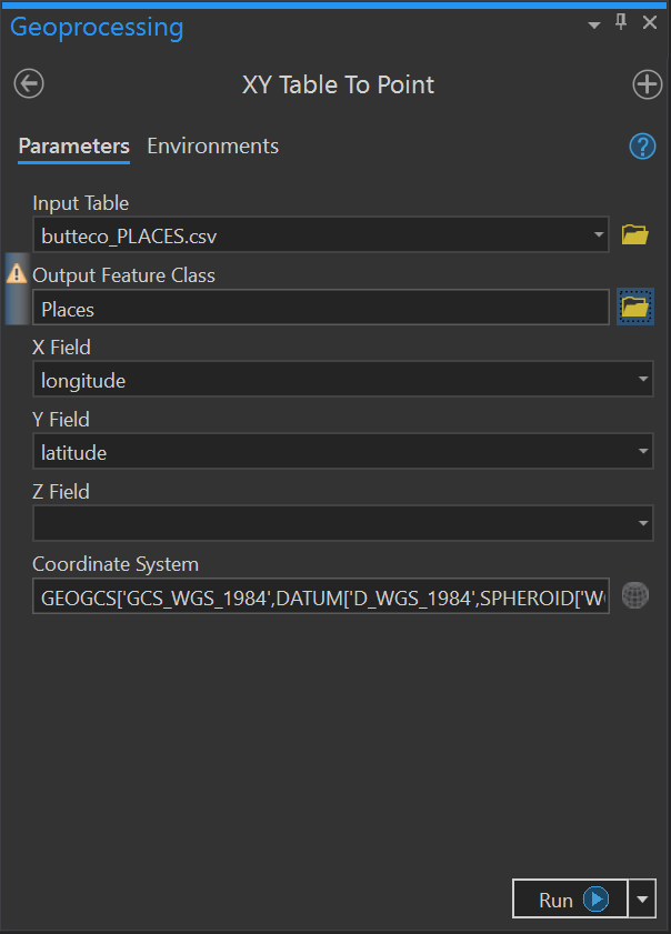
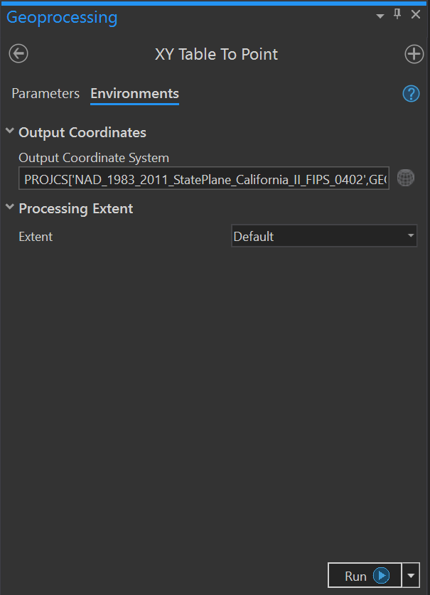
I have three (3) CSV formatted files containing geographic coordinates (I attached one). When I use XY Table to Point to create point features from any of them, I cannot get valid results if I set both the input SRS and the output SRS (via the Environment settings). In my case, the input SRS is WGS84; the desired output SRS is NAD83-2011 State Plane CA-II (0402).
 |  |
| Parameters | Environments |
|---|
The XY Table to Point tool does create points, but it misinterprets the desired output SRS as the defined input SRS and, so, plots all the points near the false origin of the CA-II coordinate system (i.e., out in the Pacific Ocean).
I now have to use a two-step process to accomplish what used to be a one-step process: 1) use XY Table to Point to create point features tied to the input SRS; then 2) use the Project tool to handle the coordinate conversion.
I'm running ArcGIS Pro 2.5.0 on Windows 10 Pro.
Solved! Go to Solution.
Accepted Solutions
- Mark as New
- Bookmark
- Subscribe
- Mute
- Subscribe to RSS Feed
- Permalink
Thank you for this post Scott Drzyzga. This problem was brought to the development team a few weeks ago and has been fixed in ArcGIS Pro 2.6 (it will be in the early adopter snapshot of ArcGIS Pro 2.6, or the public beta available in a few months if you would want to participate). For the 2.5.x release you will need to perform the additional step you explained with the Project (management) tool.
- Mark as New
- Bookmark
- Subscribe
- Mute
- Subscribe to RSS Feed
- Permalink
XY Table To Point—Data Management toolbox | Documentation
Strangely... I read that help topic that the default output coordinate system is WGS84, BUT if the "Input" coordinate is not that, then you need to specify it first. It doesn't say anything about projecting the data to your desired coordinate system.
The default coordinate system of the output feature class is the geographic coordinate system WGS 1984. If the fields in the source table contain projected coordinates, specify the appropriate projected coordinate system.
This,
Make XY Event Layer—Data Management toolbox | Documentation
doesn't offer an alternative to the Project tool step.
- Mark as New
- Bookmark
- Subscribe
- Mute
- Subscribe to RSS Feed
- Permalink
Dan, this is a workflow I've been using for years that is now generating unexpected behavior. I did specify both the input and the output SRS (see the figures in my post). The error literally occurs when I specify both (as one should if the desired output is different from the input). The reason I am posting is because this error did not occur in prior versions of ArcGIS Pro and is occurring now.
- Mark as New
- Bookmark
- Subscribe
- Mute
- Subscribe to RSS Feed
- Permalink
The help is incomplete then. They appear to be relying on the supporting "Output coordinate system" as set in the Environments tab (my bad... forgot to check it too).
So it isn't a change in behaviour and it isn't these bugs
BUG-000128741: An error occurs when running the XY Table to Point t..
BUG-000129406: The resulting feature class is missing some of the a.. but a suggestion to make a table in a gdb makes other issues go away
You might want to "Tech Support" since 2 recent bugs may mean not one else has flaggee it
- Mark as New
- Bookmark
- Subscribe
- Mute
- Subscribe to RSS Feed
- Permalink
Thank you for this post Scott Drzyzga. This problem was brought to the development team a few weeks ago and has been fixed in ArcGIS Pro 2.6 (it will be in the early adopter snapshot of ArcGIS Pro 2.6, or the public beta available in a few months if you would want to participate). For the 2.5.x release you will need to perform the additional step you explained with the Project (management) tool.
- Mark as New
- Bookmark
- Subscribe
- Mute
- Subscribe to RSS Feed
- Permalink
hello,
on pro 2.9 i have got some issues too with this tool. The parameter of the tool "coordinate system" goes suddendly wrong without any manual update on the stuff.
here is the chain i use.
have got the problem both on excel and csv

when i use a second tool "project" the transformation goes wrong too without any manual update.
very disturbing...