- Home
- :
- All Communities
- :
- Products
- :
- ArcGIS Pro
- :
- ArcGIS Pro Questions
- :
- Why does Direction/Distance "shorten" distance uni...
- Subscribe to RSS Feed
- Mark Topic as New
- Mark Topic as Read
- Float this Topic for Current User
- Bookmark
- Subscribe
- Mute
- Printer Friendly Page
Why does Direction/Distance "shorten" distance units?
- Mark as New
- Bookmark
- Subscribe
- Mute
- Subscribe to RSS Feed
- Permalink
I've been working in ArcGIS Pro 2.0.0, and I've run into quite a strange issue with the Direction/Distance tool treating distance units as being "shorter" than they should be. I've reduced it to the following test case:
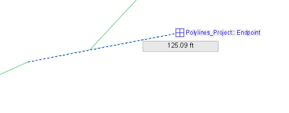
I created a new map using a projected coordinate system (NAD 1983 StatePlane Idaho West FIPS 1103 Feet) and added a polyline data set that was in the same CRS. I then used the Measure tool on a line segment and got a length of 125.09 feet.
But when I use the Create tool feature to draw a new line over that same segment, the Distance tool gives me a much larger length.
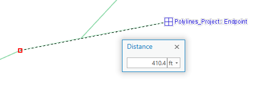
If I manually enter the "correct" distance of 125.09 feet, the resulting line is far shorter than expected.
It doesn't matter whether I just press the "D" key, right-click and select "Direction/Distance", or use the Dynamic Constraints button under the viewport; Arc acts as if a "Distance tool" foot is a lot smaller than a "map foot."
Is there something I could be doing wrong that throws the measurements off, or is Arc misbehaving?
- Mark as New
- Bookmark
- Subscribe
- Mute
- Subscribe to RSS Feed
- Permalink
125.09 / 0.3048 = 410.4 => meters / meter per foot = feet
it is a unit thing... confirm what is being used in all situations...
- Mark as New
- Bookmark
- Subscribe
- Mute
- Subscribe to RSS Feed
- Permalink
That would make sense, but Arc is reporting feet for everything in this case, so it must be a unit conversion issue (or at least a unit labeling issue) somewhere in the Arc code. I can confirm from other data sources that Arc's measure tool is producing correct values and units, so it would seem that the issue is localized to the Distance/Direction tool.