- Home
- :
- All Communities
- :
- Products
- :
- ArcGIS Pro
- :
- ArcGIS Pro Questions
- :
- Re: Texas Building Footprints
- Subscribe to RSS Feed
- Mark Topic as New
- Mark Topic as Read
- Float this Topic for Current User
- Bookmark
- Subscribe
- Mute
- Printer Friendly Page
- Mark as New
- Bookmark
- Subscribe
- Mute
- Subscribe to RSS Feed
- Permalink
Has anyone had success in converting the Microsoft building footprints data for Texas to featureclass? I tried several times using the conversion tool box but it keeps on crashing.
Solved! Go to Solution.
Accepted Solutions
- Mark as New
- Bookmark
- Subscribe
- Mute
- Subscribe to RSS Feed
- Permalink
Update: I tested importing North Dakota using the JSON to Features GP tool and it worked fine, no crashes.
I would install Pro 2.2.2 and then rested.
- Mark as New
- Bookmark
- Subscribe
- Mute
- Subscribe to RSS Feed
- Permalink
This works: https://www.arcgis.com/home/item.html?id=9da0f8ae5fee45aca11bf77f712884c8
Requires ArcGIS Pro 2.2 and ArcGIS Data Interoperability extension, or the FME 2018 product.
It worked great for me!
- Mark as New
- Bookmark
- Subscribe
- Mute
- Subscribe to RSS Feed
- Permalink
Thank you will try that!
- Mark as New
- Bookmark
- Subscribe
- Mute
- Subscribe to RSS Feed
- Permalink
I don't have the Data Interoperability Extension. I tried to use a trial version of the FME 2018 product but that is crashing too 😞 . Were you able to extract the Texas data ?
- Mark as New
- Bookmark
- Subscribe
- Mute
- Subscribe to RSS Feed
- Permalink
Sona Sunny I was able to do this with Data Interop extension. I did NOT install FME from their site.
BUG-000116435 | Performance issue when converting large GeoJSON files. |
Release notes for ArcGIS Pro 2.2—ArcGIS Pro | ArcGIS Desktop
The latest patch can be downloaded/installed via the Pro built-in updater or via My Esri. Once installed and retry the workflow, please report back. Thanks!
- Mark as New
- Bookmark
- Subscribe
- Mute
- Subscribe to RSS Feed
- Permalink
It worked!!! Pro 2.2.2 is the Winner! It took 50 min to convert the Texas Geojson file to a File geotabase feature Class. Thank you George for letting me know of the latest patch! I had almost given up on this dataset as FME also crashed and that's when saw your post!
- Mark as New
- Bookmark
- Subscribe
- Mute
- Subscribe to RSS Feed
- Permalink
Thanks for the update! I am glad to hear that it is working for you now.
- Mark as New
- Bookmark
- Subscribe
- Mute
- Subscribe to RSS Feed
- Permalink
I got this to run and work but when i looked at the attribute table it didn't have shape length or area length? Any idea of what i have to do to get it to import the height attributes?
- Mark as New
- Bookmark
- Subscribe
- Mute
- Subscribe to RSS Feed
- Permalink
There is shape area and length: See for Texas below.
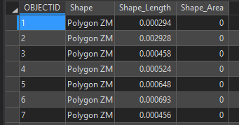
I bet the small #'s are related to the spatial reference of the data.
I do not see any data related to height attributes only the 2D representation of the building footprint.
- Mark as New
- Bookmark
- Subscribe
- Mute
- Subscribe to RSS Feed
- Permalink
Perfect. I got it to work using the FME workbench. Only problem now is my buildings are in the middle of the ocean near Africa. How did you manage to get it into EPSG: 4326? I cant find that projection anywhere in the ESRI system.