- Home
- :
- All Communities
- :
- Products
- :
- ArcGIS Pro
- :
- ArcGIS Pro Questions
- :
- divide polygon
- Subscribe to RSS Feed
- Mark Topic as New
- Mark Topic as Read
- Float this Topic for Current User
- Bookmark
- Subscribe
- Mute
- Printer Friendly Page
divide polygon
- Mark as New
- Bookmark
- Subscribe
- Mute
- Subscribe to RSS Feed
- Permalink
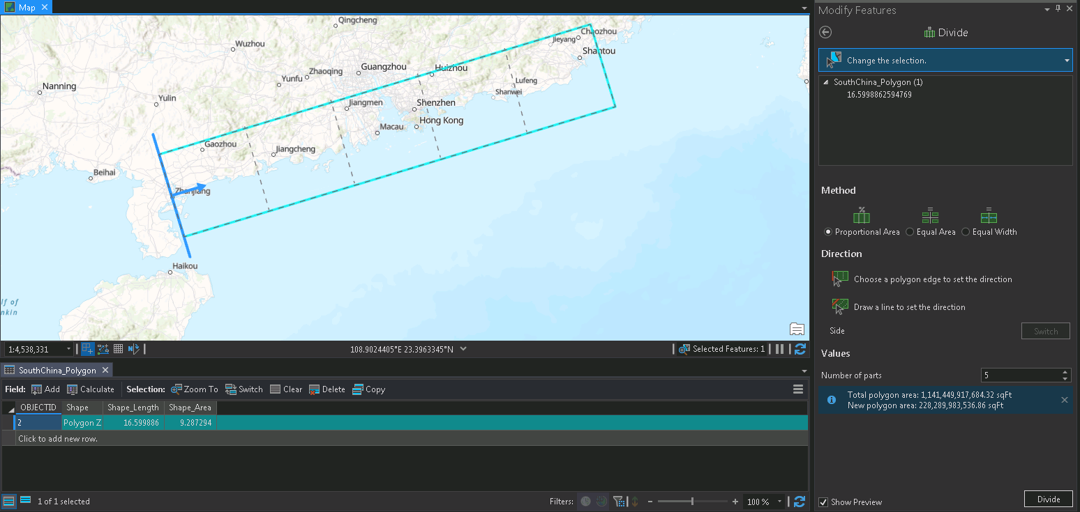
I'm sure I'm probably missing something very basic, but I created a rectangular polyon along the coastline of southern China. I then went to the Modify Features - Divide tool. I was able to select the polygon, then select the edge to set the direction of the divide, selected proportional area, and increased the number of parts to 5. The preview below shows this well, and is exactly what I want the tool to do.
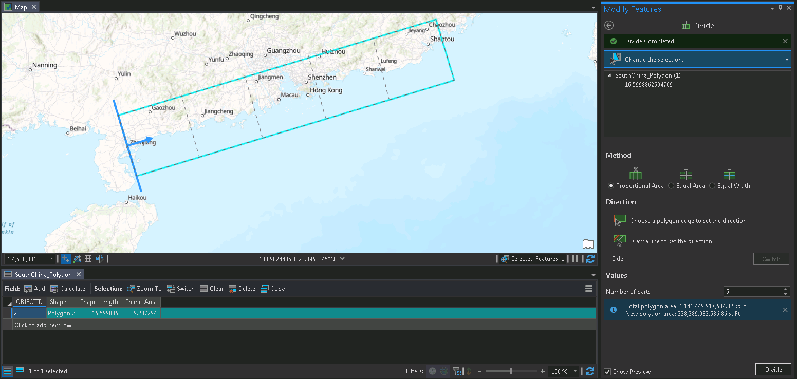
However, I hit the divide tool, it runs and says "Divide Completed", but it doesn't seem to do anything. No new polygons are created, and I cannot save the edits or anything? The existing polygon attribute table continues to show just the single original rectangular polygon. I checked the project geodatabase and there is nothing new in there either.
Tool setup shown

Shown after clicking Divide button - now showing "Divide Completed" in the upper right

- Mark as New
- Bookmark
- Subscribe
- Mute
- Subscribe to RSS Feed
- Permalink
Hi Andrew,
I can't reproduce the same problem with Divide. Some questions I have:
- What version of Pro are you using?
- What is the coordinate system of the polygon feature class?
- What is the coordinate system of the map?
- What is the source of the feature class? (ex, File Geodatabase, SQL Server EGDB, Shapefile, etc.)
- Does Check Geometry return any problems with the data? - Check Geometry—Data Management toolbox | Documentation
- If you take the same polygon feature class and add it to a map in a new project, does Divide work there?
Thanks,
Scott
- Mark as New
- Bookmark
- Subscribe
- Mute
- Subscribe to RSS Feed
- Permalink
Hi Scott-
Thank you for taking the time to reply.
- What version of Pro are you using?
- ArcGIS Pro 2.5.1 (says it's the latest version in green)
- What is the coordinate system of the polygon feature class?
- WGS 1984
- What is the coordinate system of the map?
- WGS 1984
- What is the source of the feature class? (ex, File Geodatabase, SQL Server EGDB, Shapefile, etc.)
- I created a feature class using the new feature class option after right clicking on the project geodatabase. I specified the feature class and gave it a name. I then added it to the current map, and went to create tools choosing the rectangle option. I drew the rectangle that is shown by dragging with my mouse. I then saved the edits before going to the Divide tool and trying to split this rectangle with the method described previously.
- Does Check Geometry return any problems with the data? - Check Geometry—Data Management toolbox | Documentation
- Ran check geometry and it shows no errors. (there are 4 vertices of the rectangle so a fairly simple topology)
- If you take the same polygon feature class and add it to a map in a new project, does Divide work there?
- After posting I created a new project, creating a similar rectangle within a fresh geodatabase and ran into the same issue. Also, I tried the "Split" tool just to see what would happen, and this tool works fine. I drew a line from one side to the other of my target rectangle, clicked the run button and my one polygon became two both on the map and within the attribute table.
I just tried it one last time with a new project and a new rectangle, with the same result.
Thanks again for any other thoughts you may have. I'll have to go to Esri help directly I'm guessing.
-Andrew
- Mark as New
- Bookmark
- Subscribe
- Mute
- Subscribe to RSS Feed
- Permalink
Hey Andrew,
We can reproduce this - so we are investigating ways to fix it. The problem is related to using a geographic coordinate system. With a GCS, the Divide tool ends up projecting things behind the scenes, and if there aren't enough vertices to work with, the divide lines may not end up snapping to the edges of the polygon.
A few workarounds:
- Use a projected coordinate system.
- Insert vertices using the Generalize tool (densify method), then Divide as normal. After using Divide, you could then use the Simplify method to remove the unnecessary vertices.
- Do some manual edits (not too difficult with this data since there aren't many vertices): basically add a new line layer to the map > create lines that snap along the edges of the polygon > use Divide on the line > Use Split (interactive) to create splitting lines that snap to the new endpoints.
Thanks for the additional details that allowed me to reproduce.
Scott