- Home
- :
- All Communities
- :
- Products
- :
- ArcGIS Pro
- :
- ArcGIS Pro Questions
- :
- Aggregate monthly precipitation data to administra...
- Subscribe to RSS Feed
- Mark Topic as New
- Mark Topic as Read
- Float this Topic for Current User
- Bookmark
- Subscribe
- Mute
- Printer Friendly Page
Aggregate monthly precipitation data to administrative boundaries
- Mark as New
- Bookmark
- Subscribe
- Mute
- Subscribe to RSS Feed
- Permalink
Hello all,
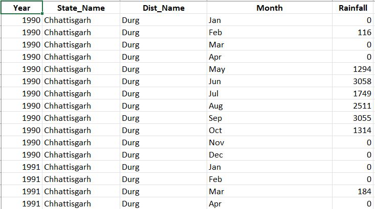
I am a complete newbie to ArcGIS Pro and this is my first time working with this type of program. For my bachelor thesis in Political Science, I am analyzing the effect of rainfall and temperature variation on social conflict in India, looking at monthly social unrest incidences of 592 Indian districts from 2016 to 2020. I have gridded data on monthly average rainfall and monthly average temperature in netCDF format for the period 1991 to 2020. Now I would like to aggregate this data so that I can calculate the monthly temperature and rainfall variation for each district and work with it in R (the resulting table should look like the attached image). Unfortunately I have no idea how to proceed here, can anyone help me? Thanks a lot already!
- Mark as New
- Bookmark
- Subscribe
- Mute
- Subscribe to RSS Feed
- Permalink
Have a look at aggregating multidimensional data