- Home
- :
- All Communities
- :
- Products
- :
- ArcGIS Parcel Fabric
- :
- ArcGIS Parcel Fabric Ideas
- :
- COGO Centerlines using Stationing Values
- Subscribe to RSS Feed
- Mark as New
- Mark as Read
- Bookmark
- Follow this Idea
- Printer Friendly Page
COGO Centerlines using Stationing Values
- Mark as New
- Bookmark
- Subscribe
- Mute
- Subscribe to RSS Feed
- Permalink
COGO Centerlines using Stationing
ESRI has not provided a useful tool for constructing centerlines since ArcCOGO in ArcEDIT. Before an editor can digitize or COGO a centerline the user has to calculate the distance from the station values. Allowing the user to choose an option to enter in distance as stations into the traverse tool will eliminate this step.
I suggest adding to the traverse options the ability to enter distance as stations below the misclose tolerance settings.
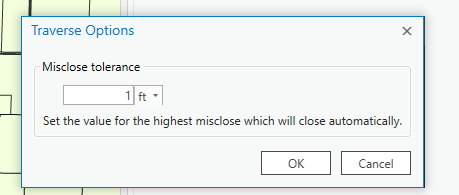
This UI would like similar to this.
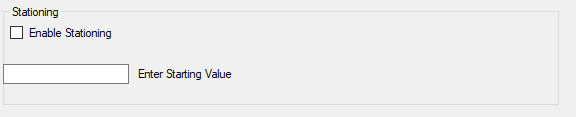
Enabling stating this changes the distance column on the traverse tool to station.
The user can then enter station distances as 10+50 or 1050. The traverse tool then calculates the dimension of the line based on the starting station or the last station entered.
For added functionality, if the fields FromStation and ToStation are included# in the target feature class the traverse tool can calculate the values. The user can then use the values as labels.
Also, include the awareness of stationed lines to ArcGIS PRO. If the user uses the divide tool on the line. ArcGIS Pro will calculate new “From Station” and “To Station” values.
Can you accomplish what you need with Create features along a line at an offset—ArcGIS Pro | ArcGIS Desktop ?
Creating features this way is commonly used with parcel workflows to create point and line features using station and offset measurements recorded on survey or engineering documents. For example, to update or create road rights-of-way points on either side of a route centerline.
That is a related task. The offset tool creates new features offset from an existing feature. This tool will assist in creating the centerline.
Here is the workflow.
- Create the centerline using the traverse tool
- Create the offsets from the centerline using the offset tool.
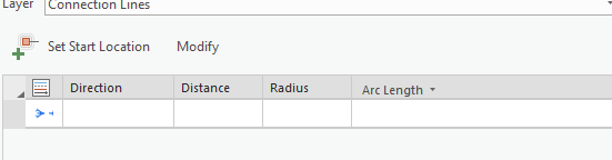
Jon, thanks for the idea. You may already be aware, but you can do basic addition and subtraction in the length/distance fields. So for example, if the start station of a course is 45+78.00 and the end station is 51+45.00, then in the Distance field you can type 5145-4578, and when you press Enter the distance is calculated and entered for you. If it is a circular arc, then you'd type that into the ArcLength field. This is not the same as what you ask for in this idea, but it does avoid having to pre-calculate the distances beforehand.
-Tim
You must be a registered user to add a comment. If you've already registered, sign in. Otherwise, register and sign in.