- Home
- :
- All Communities
- :
- Products
- :
- ArcGIS Online
- :
- ArcGIS Online Questions
- :
- Scale Visibility not changing
- Subscribe to RSS Feed
- Mark Topic as New
- Mark Topic as Read
- Float this Topic for Current User
- Bookmark
- Subscribe
- Mute
- Printer Friendly Page
Scale Visibility not changing
- Mark as New
- Bookmark
- Subscribe
- Mute
- Subscribe to RSS Feed
- Permalink
Hi. I'm new to AGOL. I'm struggling to set my scale visibility to street level. I change the scale bar, but the tiles just show up at Metropolitan range. Can anyone please help me?
Regards, Jaco
- Mark as New
- Bookmark
- Subscribe
- Mute
- Subscribe to RSS Feed
- Permalink
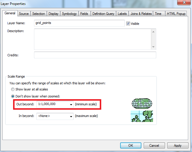
What layers are you trying to view? If it's a layer from the MXD that has been published from ArcMap, check if a visibility scale range has been defined in the layer/group properties.
Think Location
- Mark as New
- Bookmark
- Subscribe
- Mute
- Subscribe to RSS Feed
- Permalink
It may be a limit of what scales the basemap were cached.
Have you looked at the metadata for the basemap?
Is it a basemap that you created or another found online?
Can you share the URL for the basemap you are using (or the name, if a standard esri)
That might hep diagnose if there is an issue with something you are doing or if it is just a limitation based on layers used.
- Mark as New
- Bookmark
- Subscribe
- Mute
- Subscribe to RSS Feed
- Permalink
Hi. I've checked the limit on the scales and it is set to "show layer at all scales". The file is a raster with solar radiation data. The cell resolution is 5 meters. I want to be able to zoom in at least to street level in the webmap, by the raster disappears when I zoom closer than Metropolitan.
Rebecca: The basemap I add when creating the online map - I only export the raster to be added through AGOL.
Hope anyone can help me.
Regards
Jaco