- Home
- :
- All Communities
- :
- Products
- :
- ArcGIS Online
- :
- ArcGIS Online Questions
- :
- "Accessing data failed" error
- Subscribe to RSS Feed
- Mark Topic as New
- Mark Topic as Read
- Float this Topic for Current User
- Bookmark
- Subscribe
- Mute
- Printer Friendly Page
- Mark as New
- Bookmark
- Subscribe
- Mute
- Subscribe to RSS Feed
- Permalink
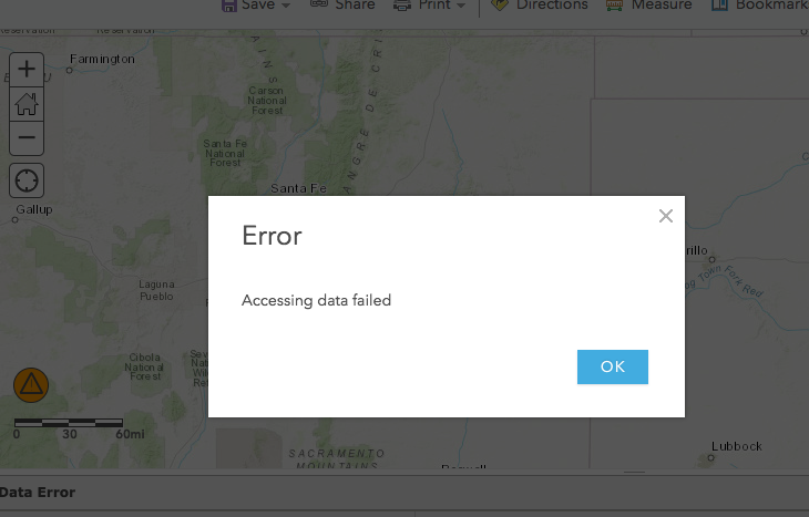
Hello, I have uploaded a .csv file to my ArcGIS account.
When I click on show table, I get an error saying "Accessing data failed". I have tried .xlsx files and .txt files and I have received the same error message.
I am currently in a Francophone country, but my ArcGIS account is with an American university so my profile region says "US". I am wondering if this has something to do with the French system where commas are used to represent decimals. The data has decimals i.e. 12.3232 and I was wondering if the platform is registering that I am in a Francophone country and therefore it is unable to read the data. Has anyone ever had an issue with this or know how to troubleshoot this?
Thanks!
 am
am
Solved! Go to Solution.
Accepted Solutions
- Mark as New
- Bookmark
- Subscribe
- Mute
- Subscribe to RSS Feed
- Permalink
I think you're on to something with the commas and the language barrier. However, this is what pulled up for me:
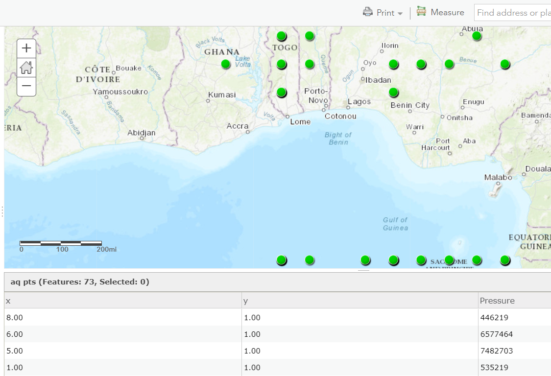
It took the value of 8650614739 and turned it into 8.00, and so on.
What values are your X and Y columns supposed to be in? AGOL expects CSV files to be in proper latitude and longitude in order for them to be read properly.
- Mark as New
- Bookmark
- Subscribe
- Mute
- Subscribe to RSS Feed
- Permalink
Daniel,
That is interesting. Is there a way to share your CSV here so it can be testing outside of French-speaking areas?
- Mark as New
- Bookmark
- Subscribe
- Mute
- Subscribe to RSS Feed
- Permalink
Hi Adrian,
Thanks for looking into this.
I've put the files on google drive (there's a csv, xlsx, txt, and xls file that are all the same data)
https://drive.google.com/open?id=1LdSDCcCCFvemEZAiklnt13mCtMxcn__q
Thanks again!
Daniel
- Mark as New
- Bookmark
- Subscribe
- Mute
- Subscribe to RSS Feed
- Permalink
I think you're on to something with the commas and the language barrier. However, this is what pulled up for me:
It took the value of 8650614739 and turned it into 8.00, and so on.
What values are your X and Y columns supposed to be in? AGOL expects CSV files to be in proper latitude and longitude in order for them to be read properly.
- Mark as New
- Bookmark
- Subscribe
- Mute
- Subscribe to RSS Feed
- Permalink
So in the instructions for my assignment it says "In the Spatial Reference Properties dialog, scroll down and expand the Projected Coordinate Systems then select the State Plane folder, then NAD 1927 (US Feet), then select NAD 1927 StatePlane Texas N Central FIPS 4202 and press the OK button"
Note: these instructions are for the desktop version of ArcGIS. In the class example, the professor is able to click on a button that says "Display XY data". This doesn't seem to be an option in the online version am I right? If so, how do you change the coordinate description?
I was able to get the file uploaded correctly using .xlsx! Now I am now getting the same coordinates as you instead of the coordinates from Texas I'd like to see.
Thanks for your help!
- Mark as New
- Bookmark
- Subscribe
- Mute
- Subscribe to RSS Feed
- Permalink
Daniel,
Yes, changing the coordinate system is a desktop thing. Do you have access to the desktop software? This is where you would display the data in the State Plane system like you mentioned. After doing so, you could export your data to the WGS 84 system to get lat/long coordinates, or just export to a shapefile with an appropriate projection and AGOL will read it just fine.
What is it you are needing to do exactly? And for school assignments, it's best to work them out on your own and usually ask your professor/instructor for help when needed.