- Home
- :
- All Communities
- :
- Products
- :
- ArcGIS Online
- :
- ArcGIS Online Questions
- :
- Drawing new layer (add map notes) on arcGIS online...
- Subscribe to RSS Feed
- Mark Topic as New
- Mark Topic as Read
- Float this Topic for Current User
- Bookmark
- Subscribe
- Mute
- Printer Friendly Page
Drawing new layer (add map notes) on arcGIS online, getting the total area
- Mark as New
- Bookmark
- Subscribe
- Mute
- Subscribe to RSS Feed
- Permalink
I am trying to put together an activity for school groups to introduce them to ArcGIS online in an interactive and meaningful way without the need for people to go outside to take points/lines/polygons. Our activity is being built around arcmaps online, and we are getting them to draw polygons over specific habitat types (woodland, savanna, prairie etc.). For each of those new polygons we need to know the area, and I cannot figure out a simple way to get the area of a newly drawn polygon (created using "add map notes"). I know that there is the measurement tool, but that means they have to draw essentially two polygons for each new polygons. I feel like there has to be an easier and more straightforward way to get the area out of these new shapes. Any ideas?
- Mark as New
- Bookmark
- Subscribe
- Mute
- Subscribe to RSS Feed
- Permalink
Hey Sarah! Another user might have more insight into this but I just did some quick testing and if you're using the map notes to create the polygons then I'm not familiar with a way to easily calculate the area from that. '
However, if these were features created in ArcGIS Pro or ArcMap and then published to ArcGIS Online you're students could calculate the area with the attribute table (this is of course is reliant on how much of our software outside of ArcGIS Online that the students are familiar with).
Just my two cents! I hope your activity goes well!
EDIT: I wanted to include this article in case it is helpful to you - FAQ: Is it possible to calculate area in ArcGIS Online?
- Mark as New
- Bookmark
- Subscribe
- Mute
- Subscribe to RSS Feed
- Permalink
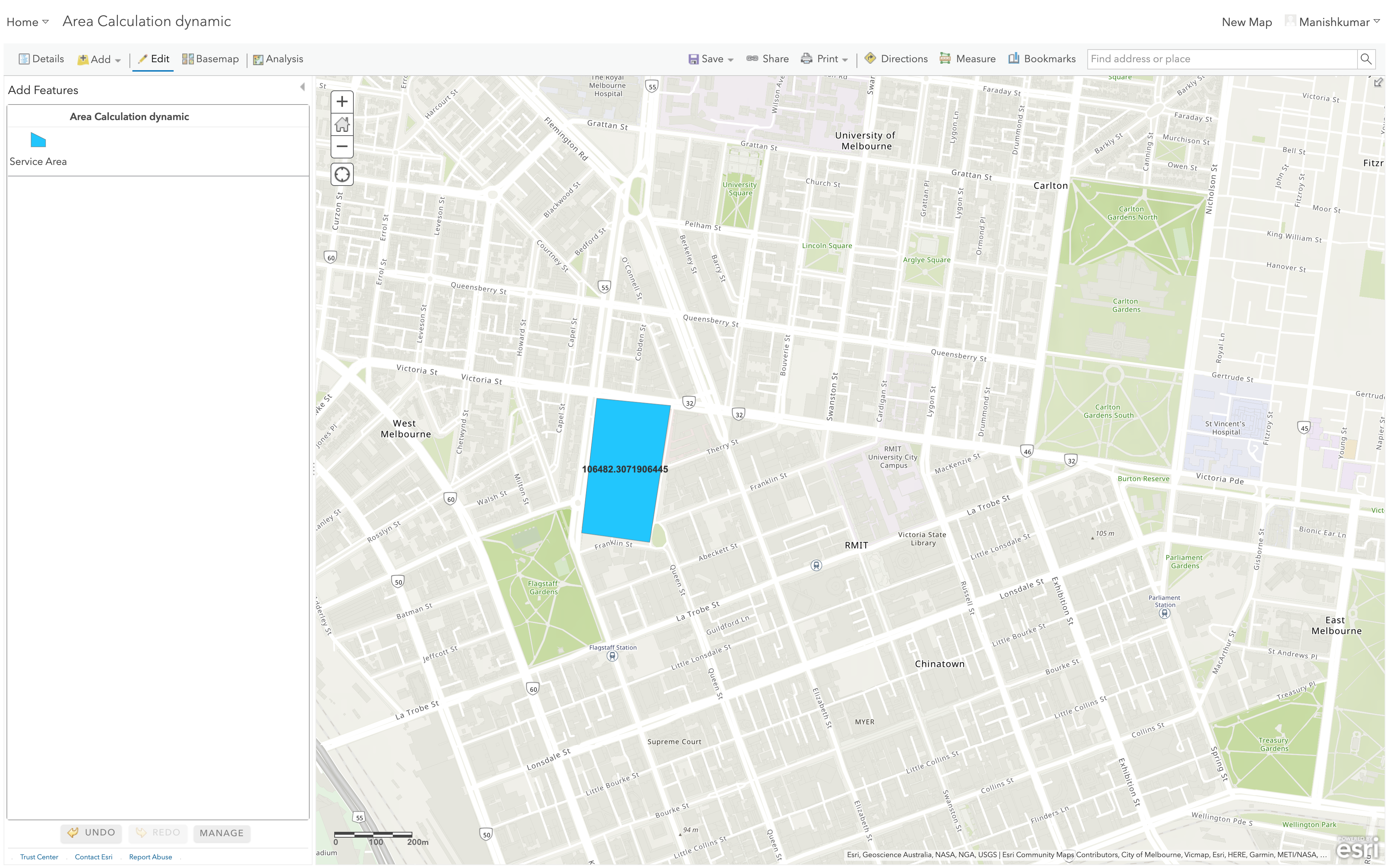
Sarah-Cody Knight, this can be achieved with some pre-configuration done to a feature layer that can be used for creating polygons.
What I have done to achieve this is as below:
- Create a feature layer that can create polygons.
- Add the feature layer to the web map with full editing control.
- Once the layer is added click on the 3 dots for more options
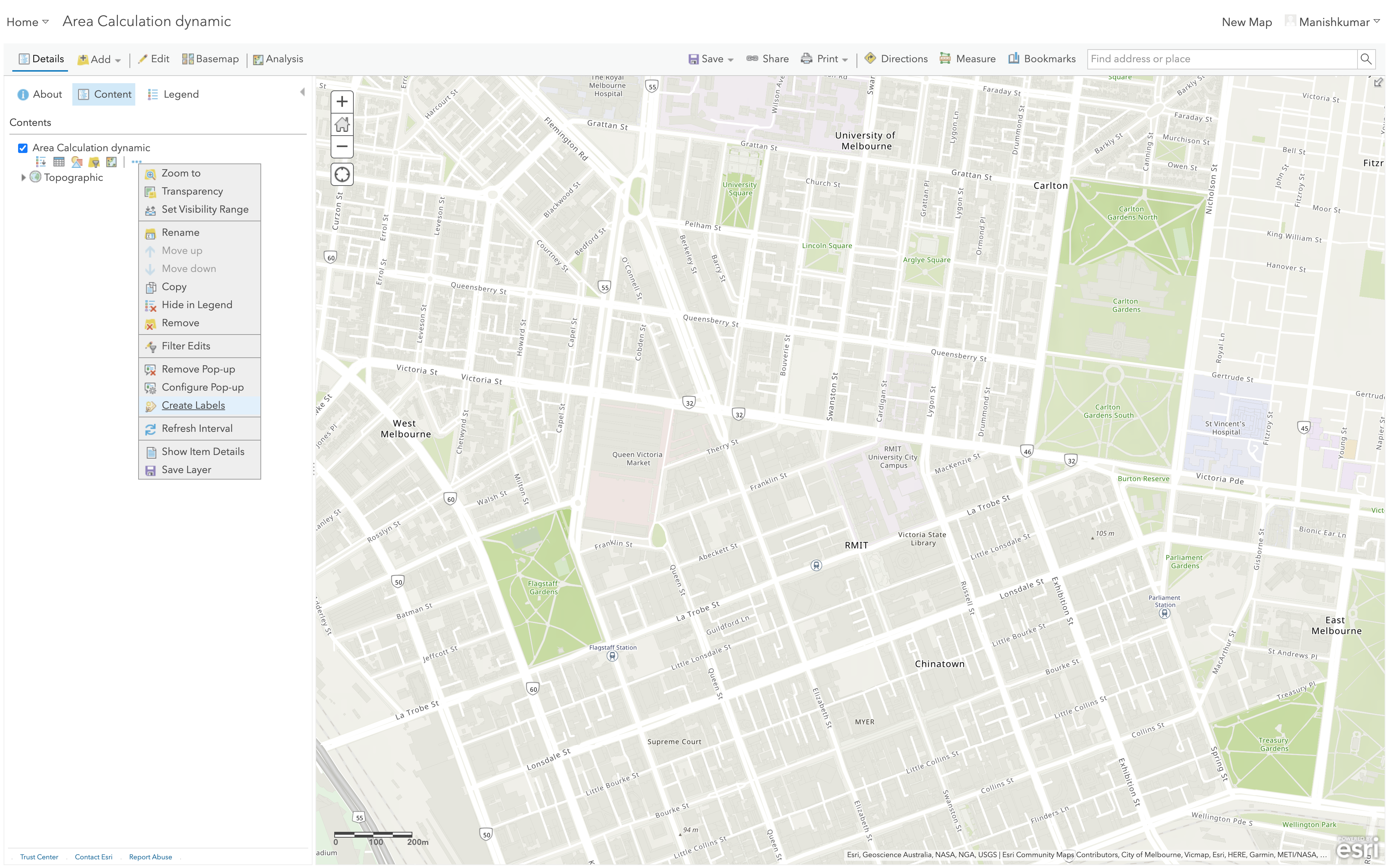
- Select 'Create labels'
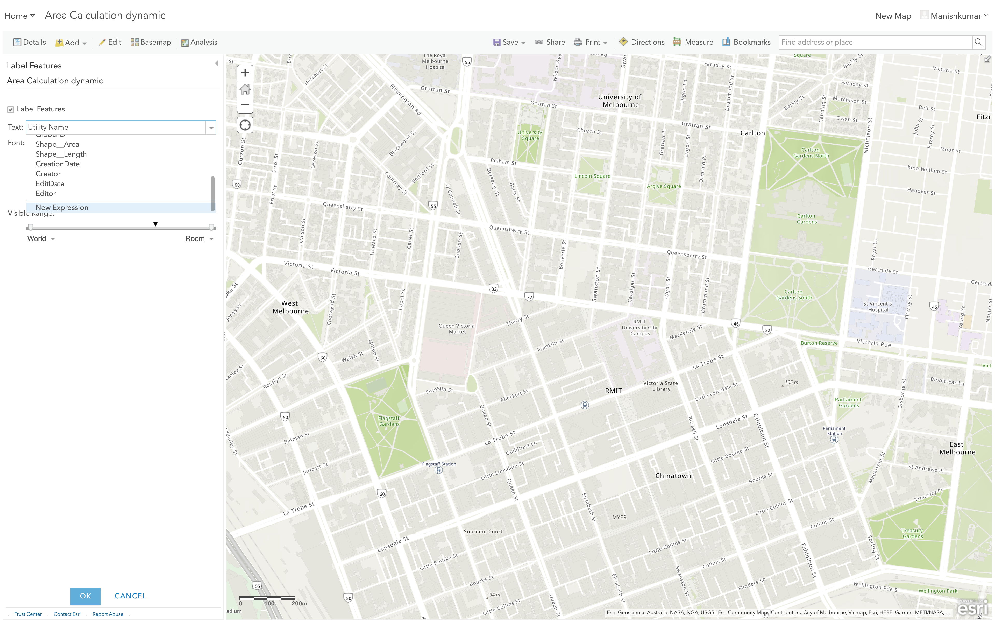
- Under the Label Features, options select Text dropdown and scroll down to 'New Expression'
- Select Functions on the right and select the 'Area' function
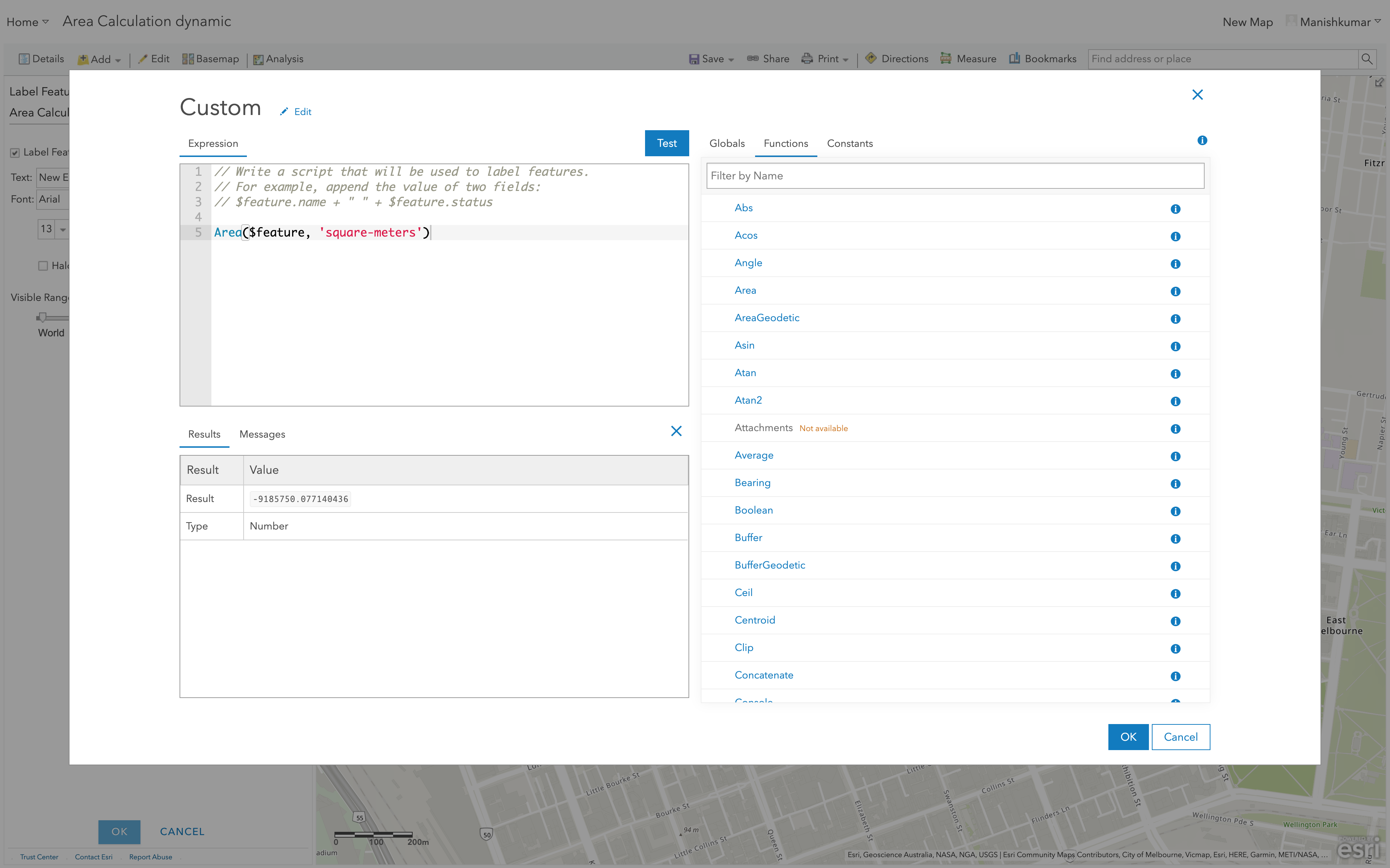
- Click 'Test' to verify if the results look fine, you can change the format or units if you would like.
- Save this web map and the students can use the web map to draw the polygons. The attributes can be used to store the descriptions
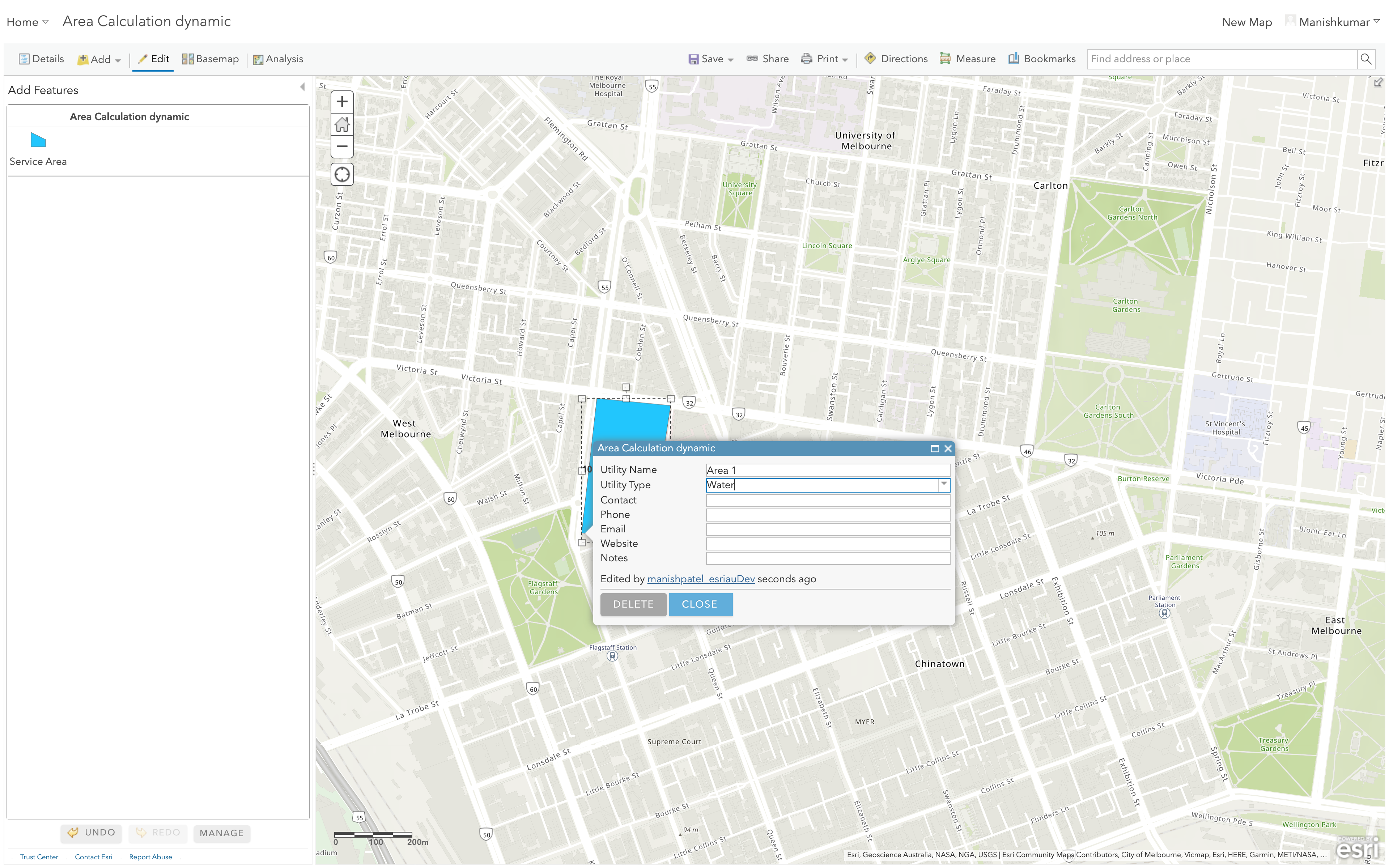
- Once the polygon is drawn it will automatically create the area label. TADAA!
Hope this helps.
Cheers,
Manish
Manish
- Mark as New
- Bookmark
- Subscribe
- Mute
- Subscribe to RSS Feed
- Permalink
Sarah-Cody Knight wondering if you got a chance to view the above mentioned solution.
Manish
- Mark as New
- Bookmark
- Subscribe
- Mute
- Subscribe to RSS Feed
- Permalink
Hi Manish,
I will try the above suggestion, as it does seem to circumvent the issue and I very much so appreciate that. We had to change the activity a little bit and ended up just providing our own polygons for the activity, including creating a buffer layer to represent forest succession in a prairie habitat.
Thank you for your help,
Sarah-Cody
- Mark as New
- Bookmark
- Subscribe
- Mute
- Subscribe to RSS Feed
- Permalink
Sarah-Cody Knight, you are most welcome. I wish I would have provided the workaround a little earlier 🙂
Feel free to reach out to us anytime you need any further help.
Please don't forget to mark the question as answered, this will help other users, easy to find solutions.
Good luck and cheers,
Manish
Manish