Turn on suggestions
Auto-suggest helps you quickly narrow down your search results by suggesting possible matches as you type.
Cancel
- Home
- :
- All Communities
- :
- Products
- :
- ArcGIS Network Analyst
- :
- ArcGIS Network Analyst Questions
- :
- Optimal location determination based on distance o...
Options
- Subscribe to RSS Feed
- Mark Topic as New
- Mark Topic as Read
- Float this Topic for Current User
- Bookmark
- Subscribe
- Mute
- Printer Friendly Page
Optimal location determination based on distance over existing road network
Subscribe
6982
8
03-07-2012 12:14 AM
03-07-2012
12:14 AM
- Mark as New
- Bookmark
- Subscribe
- Mute
- Subscribe to RSS Feed
- Permalink
Hi,
I am currently facing a biomass storage location optimization problem. The aim is to determine the optimal location of a biomass storage site, for which total transport distance to be traveled over the existing road network is minimized.
To be more specific:
I currently have 2 different layers:
- First: a point layer which can be consists of more than 1000 departure location for biomass transport. From each departure location, the biomass is transported to the storage site of which the location is to be determined.
- Second: a layer which shows the existing road network in the study area
The aim is now to determine the location in the study area for which the total distance from all the departure points over the existing road network is minimized. This location is then considered as the optimal biomass storage site.
Another assumption is that the biomass storage site is located next to/on a road and not in the middle of example an agricultural parcel.
Could somebody please help me with this problem? I hope my explanation is clear...
Many thanks in advance !
8 Replies
03-08-2012
01:08 PM
- Mark as New
- Bookmark
- Subscribe
- Mute
- Subscribe to RSS Feed
- Permalink
It sounds like you can use the location-allocation solver for your study. It choses sites from candidate sites based on network impedance and other factors. The following are a couple of resources to help you get started, but I'll try to answer some of your other questions below:
You'll need a network dataset, so you can use the road network to create a network dataset. However, you may want to avoid this process and use an existing network dataset. See this post for a list of network dataset options, but I recommend using the one provided with the Data & Maps media to get started.
The 1000 departure locations for biomass transport would be your demand points.
You'll need another layer; one that represents potential "facility" sites. ("Facilities" represent biomass storage sites in your analysis.) It sounds like you don't have this information, and you want to assume a site can be located anywhere. Location-allocation can choose only from a finite number of locations, so what you can do is create a point feature class with facilities uniformly dispersed throughout your study area or along the network to home in on the best location.
Network Analyst always assumes facilities, demand points, etc., are located directly on the road network, so this need not be a concern for you. Even when point symbols representing facilities etc. are displayed off the network, they are treated as if they are on the nearest point of the network. To avoid any confusion about where the sites are located on the network, choose to Snap to Position along Network as shown here when you load your facilities into a location-allocation layer.
Good luck,
Robert
I currently have 2 different layers:
- First: a point layer which can be consists of more than 1000 departure location for biomass transport. From each departure location, the biomass is transported to the storage site of which the location is to be determined.
- Second: a layer which shows the existing road network in the study area
You'll need a network dataset, so you can use the road network to create a network dataset. However, you may want to avoid this process and use an existing network dataset. See this post for a list of network dataset options, but I recommend using the one provided with the Data & Maps media to get started.
The 1000 departure locations for biomass transport would be your demand points.
You'll need another layer; one that represents potential "facility" sites. ("Facilities" represent biomass storage sites in your analysis.) It sounds like you don't have this information, and you want to assume a site can be located anywhere. Location-allocation can choose only from a finite number of locations, so what you can do is create a point feature class with facilities uniformly dispersed throughout your study area or along the network to home in on the best location.
Another assumption is that the biomass storage site is located next to/on a road and not in the middle of example an agricultural parcel.
Network Analyst always assumes facilities, demand points, etc., are located directly on the road network, so this need not be a concern for you. Even when point symbols representing facilities etc. are displayed off the network, they are treated as if they are on the nearest point of the network. To avoid any confusion about where the sites are located on the network, choose to Snap to Position along Network as shown here when you load your facilities into a location-allocation layer.
Good luck,
Robert
03-20-2012
04:53 AM
- Mark as New
- Bookmark
- Subscribe
- Mute
- Subscribe to RSS Feed
- Permalink
Thanks a lot Robert !
08-17-2012
06:13 AM
- Mark as New
- Bookmark
- Subscribe
- Mute
- Subscribe to RSS Feed
- Permalink
Hi,
I think i am facing a similar issue, but with very different data. My task is to determine the optimal location of Water Leak Sensors, to cover as much of the network as possible, using as few sensors as possible. My thinking is:
I have a 'Network' in the form of waterpipes
I have 'Facilities' points in the form of water meter locations (sensors are placed on meters, so I'm using water meters can act as a proxy)
I have 'Demand' points in the form of water meter locations (I'm need to hit as many other meters on the network to ensure coverage)
Does this seem correct?
08-17-2012
08:28 AM
- Mark as New
- Bookmark
- Subscribe
- Mute
- Subscribe to RSS Feed
- Permalink
You can use Location-Allocation with it. Make all your water meters both candidate facilities as well as demand points. Then choose the minimize facilities option and add any distance cutoff if applicable and solve. It will find the minimum number of sensors needed to cover the water meters.
Jay Sandhu
Jay Sandhu
08-20-2012
07:31 AM
- Mark as New
- Bookmark
- Subscribe
- Mute
- Subscribe to RSS Feed
- Permalink
Hi Everybody,
I have a similar problem too. I have to determine the best location of stations along a national road network taking into account intersections (as best location) and maximal distance between my stations.
In brief, what I need to do is create points features on my roads network (polylines), at intersections, every XX km.
Now, looking at your thread I understand that a good (?) way to do this would be to:
1. Creates points at my intersections (using network analysis?) and
2. Then use these points to run the location-allocation tool
Ideally, and if possible, I would like to build a model that allows me to determine the points (stations) automatically (as it is at a national scale and that the parameters are likely to change).
Is this a good method or would you recommend something different? Also, Is it possible to obtain the same resutle without the mentionned extention? My current licence does not allow me to use these tools...
Many thanks in advance!
Lisa
08-22-2012
08:22 AM
- Mark as New
- Bookmark
- Subscribe
- Mute
- Subscribe to RSS Feed
- Permalink
You can use Location-Allocation with it. Make all your water meters both candidate facilities as well as demand points. Then choose the minimize facilities option and add any distance cutoff if applicable and solve. It will find the minimum number of sensors needed to cover the water meters.
Jay Sandhu
Hi Jay
thanks for the reply. I did as you stated above but am a little unsure of the outcome. Here's what i did:
1. Created a Network consisting of meters, water mains and laterals
2. Loaded all meters into my 'facilities' and set the [name] = meter ID
3. Loaded all meters into my 'demand points and set the [name] = meter ID
4. Chose 'Minimize Facilities' and set 'Impedance Cutoff' to 250ft (remember, each detector can cover 250ft).
I get why i need to chose 'Minimize Facilities' (to result in the lowest number of detectors possible to cover an area), but I'm seeing results where 2 neighbouring 'candidates' are getting chosen, despite being less than 250ft apart. Why is this?
See the image for clarification.
Any help is appreciated.
Andrew
[ATTACH=CONFIG]17157[/ATTACH]
08-22-2012
11:36 AM
- Mark as New
- Bookmark
- Subscribe
- Mute
- Subscribe to RSS Feed
- Permalink
I get why i need to chose 'Minimize Facilities' (to result in the lowest number of detectors possible to cover an area), but I'm seeing results where 2 neighbouring 'candidates' are getting chosen, despite being less than 250ft apart. Why is this?
It may be that that your water/wastewater network is disconnected and you cannot actually reach the meters that seem to be within 250 meters. Try to load two meters (which are both facilities and demand points in your location-allocation problem) in to a route layer, set the route impedance attribute to be your length field and solve the route. If no route shape is generated then the edges are not connected. If a route shape is generated then look at the field for the route distance and make sure it is less than your 250 meter cutoff.
You can probably resolve any connectivity when creating network datasets from geometric networks by:
1. Running the integrate tool ( http://resources.arcgis.com/en/help/main/10.1/index.html#//00170000002s000000 ). This tool will make sure that all features that are coincident within a tolerance you provide are made to be exactly coincident. If two water lines cross then a common vertex will be added to both of them which will enable connectivity in the network dataset.
2. Changing your network dataset connectivity policy (found on the Connectivity tab of the network dataset properties in Catalog) from "End Point" to "Any Vertex". This is needed if your geometric network had complex edges because complex edges allow mid-span connectivity but the network dataset connectivity policy of "End Point" only allows for connections at the beginning and end of an edge. ( for more on network dataset connectivity see this: http://resources.arcgis.com/en/help/main/10.1/index.html#/Understanding_connectivity/004700000009000... )
3. Rebuild you network (using either GP or the build button on the network analyst toolbar).
The problem that you are trying to solve should work just fine so there is probably a data problem that need resolving.
Doug
08-22-2012
11:44 AM
- Mark as New
- Bookmark
- Subscribe
- Mute
- Subscribe to RSS Feed
- Permalink
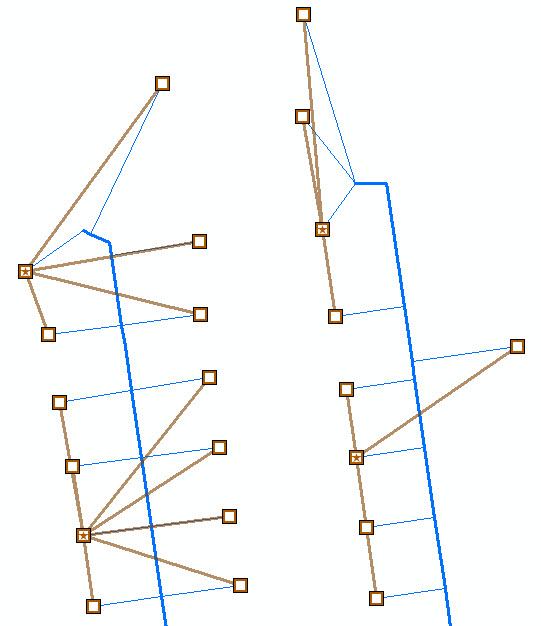
Hi Douglas,
You (and Jay, whom I spoke to earlier) were both exactly right. My laterals were not correctly connected to my Mains. Additionally, I was forced to split my mains at each intersection with a lateral. This required a lot of clean up to removed dangles/short falls....
However, after all of that the results make much more sense. The attached image shows each 'chosen' meter and the meters it can detect leaks against...
Thank you all for your help.
[ATTACH=CONFIG]17162[/ATTACH]