Turn on suggestions
Auto-suggest helps you quickly narrow down your search results by suggesting possible matches as you type.
Cancel
- Home
- :
- All Communities
- :
- Products
- :
- Mapping and Charting Solutions
- :
- Mapping and Charting Questions
- :
- OIS creation and ArcGIS workspace environment
Options
- Subscribe to RSS Feed
- Mark Topic as New
- Mark Topic as Read
- Float this Topic for Current User
- Bookmark
- Subscribe
- Mute
- Printer Friendly Page
OIS creation and ArcGIS workspace environment
Subscribe
6151
6
06-26-2013 06:31 AM
06-26-2013
06:31 AM
- Mark as New
- Bookmark
- Subscribe
- Mute
- Subscribe to RSS Feed
- Permalink
Hello,
1: How can i create OIS in arcgis aviation: Charting? Which is the workflow starting with the gdb creation? I've tried in ICAO annex
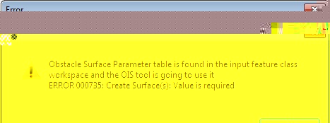
15 function , with z enable runway and AIS schema applied to the gdb. The script stops with error 000735: 'surface value is required'
2 : after creation , is that possible to visualize, edit and extract features ('obstacle') in argis environment using las or raster dem format ?
thank you
1: How can i create OIS in arcgis aviation: Charting? Which is the workflow starting with the gdb creation? I've tried in ICAO annex
15 function , with z enable runway and AIS schema applied to the gdb. The script stops with error 000735: 'surface value is required'
2 : after creation , is that possible to visualize, edit and extract features ('obstacle') in argis environment using las or raster dem format ?
thank you
6 Replies
06-27-2013
07:23 AM
- Mark as New
- Bookmark
- Subscribe
- Mute
- Subscribe to RSS Feed
- Permalink
Hey Gabriele,
First, please see another similar post outlining some of the requirements for the ICAO 14 OIS tool you may find useful. http://forums.arcgis.com/threads/82780-HELP-TOOL-ICAO-Annex-14?p=291771#post291771
The error you are seeing seems like the parameters for any of the surfaces are not populated. This typically means the ObstacleSurfaceParameter table is either not present or not populated within your Production Database. Depending on your version of ArcGIS, we have removed this requirement in newer versions meaning you can run the tools without the table. The latest version of ArcGIS for Aviation is 10.1 SP1 QFE5 and can be downloaded here http://support.esri.com/en/downloads/patches-servicepacks/view/productid/157/metaid/1983.
As for the visualization of obstructions, this is possible in ArcScene. Our recommendation is that all datasets used for a visual analysis in ArcScene must be in the same projected coordinate system. Some feature layers may need to have an extrusion applied using the actual height of the object.
In the upcoming 10.2 release, the ArcGIS for Aviation package will offer an automated analysis tool that currently compares TIN OIS features against point features and LAS files. The output of this tool is a point feature class outlining all features within the comparison areas and the difference between the obstruction and the OIS surface.
Please let us know if you have any other questions.
06-28-2013
07:13 AM
- Mark as New
- Bookmark
- Subscribe
- Mute
- Subscribe to RSS Feed
- Permalink
Hi and thank your for your quick and clear reply. Some comments are written below
please let me know as possible,
regards
Gabriele
please let me know as possible,
regards
Gabriele
Hey Gabriele,
First, please see another similar post outlining some of the requirements for the ICAO 14 OIS tool you may find useful. http://forums.arcgis.com/threads/82780-HELP-TOOL-ICAO-Annex-14?p=291771#post291771
The error you are seeing seems like the parameters for any of the surfaces are not populated. This typically means the ObstacleSurfaceParameter table is either not present or not populated within your Production Database. Depending on your version of ArcGIS, we have removed this requirement in newer versions meaning you can run the tools without the table. The latest version of ArcGIS for Aviation is 10.1 SP1 QFE5 and can be downloaded here http://support.esri.com/en/downloads/patches-servicepacks/view/productid/157/metaid/1983.
I've checked : the table exist ,but i cannot populate that table with the production library , i don't know why . So i tried to install the patch , but while following letterally the pre-requirements , appears this message:"Impossible to install the patch because there isn't the sw (???) to be update or the version is different....." .Please see in attachment if my sw profile is wrong.
As for the visualization of obstructions, this is possible in ArcScene. Our recommendation is that all datasets used for a visual analysis in ArcScene must be in the same projected coordinate system. Some feature layers may need to have an extrusion applied using the actual height of the object.
Ok, perfect
In the upcoming 10.2 release, the ArcGIS for Aviation package will offer an automated analysis tool that currently compares TIN OIS features against point features and LAS files. The output of this tool is a point feature class outlining all features within the comparison areas and the difference between the obstruction and the OIS surface.
Very good news . This tool could become the new commercial standard for obstacle chart production
Please let us know if you have any other questions.
07-01-2013
08:09 AM
- Mark as New
- Bookmark
- Subscribe
- Mute
- Subscribe to RSS Feed
- Permalink
Hey Gabriele,
From the error messages you have provided, it seems your ObstacleSurfaceParameter table is empty. From here you have two options. With MCS 10.1 SP1 QFE5 installed,you can delete the ObstacleSurfaceParameter table from your Production Database and the OIS tools will simply use the default values from the specifications. If you want to maintain your own values within the table, your second option is to populate the table with the recordset XML I have attached. You should be able to do this using the simple data loader.
If you are in an enterprise environment, don't forget to enable versioning on the tables to ensure you will be able to edit them.
07-08-2013
03:19 PM
- Mark as New
- Bookmark
- Subscribe
- Mute
- Subscribe to RSS Feed
- Permalink
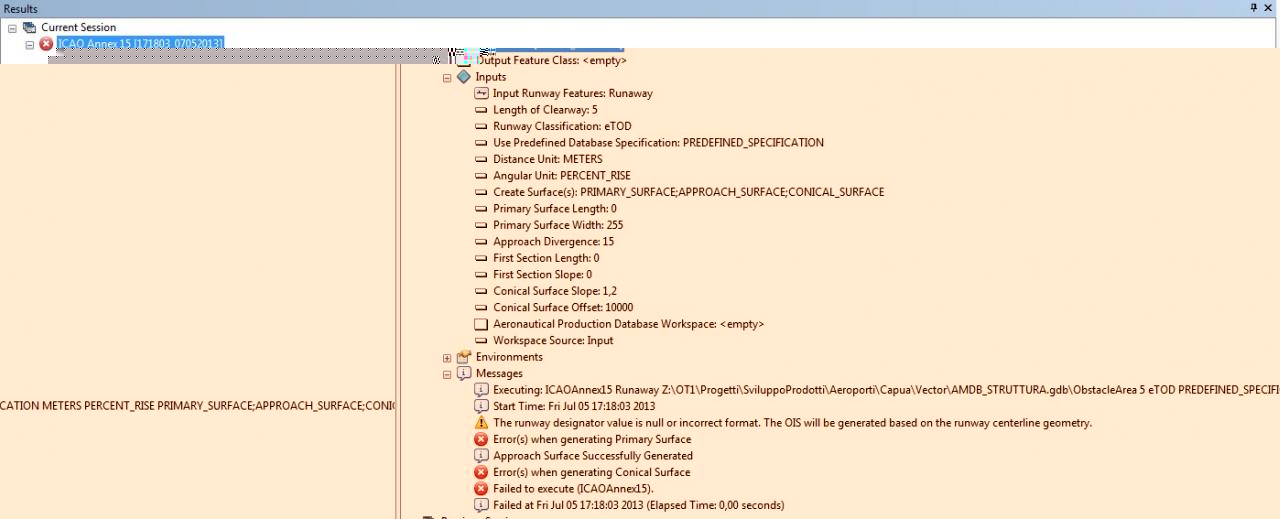
Hey Gabriele,
Thank you for the screenshot of the geoprocessing message. From the message it seems the Output Feature Class is not being recognized. It is clear you have entered it as a parameter on your Z drive in a file geodatabase. My next question is the Z drive locally on your machine or over a network?
If this is a network drive, can you please try the same workflow locally on your machine? Another thing to possibly try is to define a new shapefile as an output to the tool as well. You can do this by navigating to a folder location and defining a shapefile name and type (eg. OISOutput.shp).
If neither of these suggestions work, please let me know and we can schedule a webcast with you to see your workflow and help you through this.