- Home
- :
- All Communities
- :
- Products
- :
- ArcGIS Explorer
- :
- ArcGIS Explorer Questions
- :
- Re: .tpk Imagery not displaying within Offline Map...
- Subscribe to RSS Feed
- Mark Topic as New
- Mark Topic as Read
- Float this Topic for Current User
- Bookmark
- Subscribe
- Mute
- Printer Friendly Page
.tpk Imagery not displaying within Offline Map in Explorer on iOS
- Mark as New
- Bookmark
- Subscribe
- Mute
- Subscribe to RSS Feed
- Permalink
Hi all,
I'm trying to create a .mmpk with imagery for offline field use. No matter what I try I can't seem to get the imagery to display in Explorer on iOS.
I have re-created the tile from the original GeoTIFF multiple times, sometimes through ArcGIS Desktop 10.5 and sometimes through ArcGIS Pro, at a few different levels of detail. Each time I've added the .tpk to my ArcGIS Pro map and exported the map as a mobile map package .mmpk but when I load the .mmpk onto an iPad the imagery does not display. I've tried loading both through side loading via iTunes and by uploading the .mmpk to ArcGIS Online and downloading it on to the iPad. The imagery layer is in the list of layers, and in the map thumbnail you can see the imagery, but not when you open that map. I have no problem viewing the imagery in the ArcGIS Pro.
The imagery should be in the .mmpk as the file size represents the over 1 GB of tile data. I can turn off all of my other layers but still the imagery is not visible.
Does anyone have recommendations for what else I can try? When I analyze the map before creating the .mmpk no warnings pop up.
Joel Whitney Mark Bockenhauer
Solved! Go to Solution.
Accepted Solutions
- Mark as New
- Bookmark
- Subscribe
- Mute
- Subscribe to RSS Feed
- Permalink
Sam,
Make sure the coordinate system of the TPK and the Map are the same. A TPK does not project on the fly in Esri runtime applications, like Explorer for ArcGIS and AppStudio.
Mark
- Mark as New
- Bookmark
- Subscribe
- Mute
- Subscribe to RSS Feed
- Permalink
Sam,
Make sure the coordinate system of the TPK and the Map are the same. A TPK does not project on the fly in Esri runtime applications, like Explorer for ArcGIS and AppStudio.
Mark
- Mark as New
- Bookmark
- Subscribe
- Mute
- Subscribe to RSS Feed
- Permalink
Thank you for the quick reply Mark, it is much appreciated.
It turns out that my map wasn't in the projection that I thought it was and didn't match the .tpk. As soon as I changed the projection and re-exported the .mmpk it worked.
It would be great if in the future ESRI could add this as a warning or error when you click analyze in the Package Mobile Map tool. I actually didn't double check my projection specifically because I assumed that it would have been flagged as an error.
- Mark as New
- Bookmark
- Subscribe
- Mute
- Subscribe to RSS Feed
- Permalink
If the coordinate system of the .TPK and the Map are the same, and the imagery still doesn't display in Explorer, is there something else to try?
- Mark as New
- Bookmark
- Subscribe
- Mute
- Subscribe to RSS Feed
- Permalink
Brian,
How do you have your map set up? Is the .TPK part of a basemap in your map?
If yes, do you have any other layers, poly, line or point feature layers in the basemap?
There is a bug in mobile map packaging where TPK and VTPK layers can be written in-correctly if feature layers are also in the basemap. This problem does not occur when TPK and VTPK are packaged as operational layers, so that is one way to work around the problem. Or, do not put Feature Layers in your basemap, if you are using TPK layers and VTPK layers.
Mark
- Mark as New
- Bookmark
- Subscribe
- Mute
- Subscribe to RSS Feed
- Permalink
Hey Mark. I just got it working.
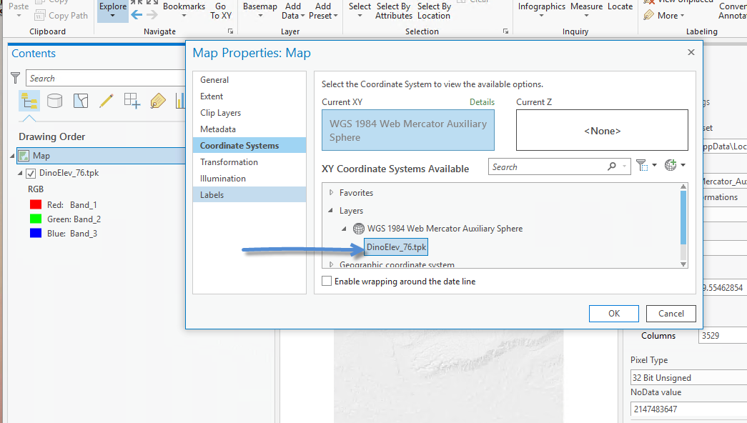
Might there be a difference between selecting the same coordinate system for both the map and the .tpk, and setting the coordinate system of your map by selecting the coordinate system of the .tpk? I did the latter and the airphoto in the .mmpk displays in explorer now.
Brian Hall
GIS Coordinator
Washington State Parks & Recreation
1111 Israel Road SW | Olympia, WA 98501-2650
Phone (360) 902-8691
[email protected]<mailto:[email protected]>
- Mark as New
- Bookmark
- Subscribe
- Mute
- Subscribe to RSS Feed
- Permalink
Sounds like they were different.
So just to be clear in map properties you set the coordinate system by choosing the layer, and then it worked fine.
One other thing to be aware of with ArcGIS Pro. If your TPK was in a basemap, you then used the basemap in your map, and then added an operational layer to your map, the coordinate system of the map will switch to the coordinate system of the added layer.
The behavior can be controlled in ArcGIS Pro -- Options
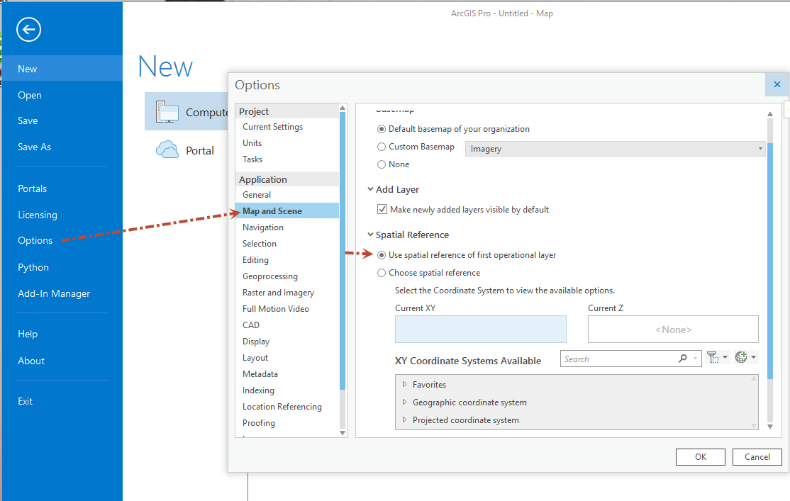
Mark
- Mark as New
- Bookmark
- Subscribe
- Mute
- Subscribe to RSS Feed
- Permalink
Yep, I set the coordinate system by choosing the layer, and then it worked fine.
I’ve got the .mmpk working now. Thanks for all your help.
Brian