- Home
- :
- All Communities
- :
- Products
- :
- ArcGIS Enterprise
- :
- ArcGIS Enterprise Questions
- :
- Re: upgrade 9.3.1 to 10.5?
- Subscribe to RSS Feed
- Mark Topic as New
- Mark Topic as Read
- Float this Topic for Current User
- Bookmark
- Subscribe
- Mute
- Printer Friendly Page
upgrade 9.3.1 to 10.5?
- Mark as New
- Bookmark
- Subscribe
- Mute
- Subscribe to RSS Feed
- Permalink
- Report Inappropriate Content
Howdy... We've got a 10.5 server deployment in progress and what I would like to do is a proof of concept migration
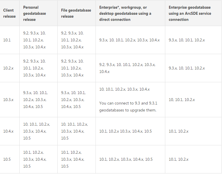
from the existing application on 9.3.1 ArcSDE - to 10.5. We have a 10.5 desktop installed, but it looks like there is no functionality available to connect through the ArcSDE service on 9.3.1. The table indicates that we can connect through SDE from 10.2, or via a database connection "for upgrade purposes" from 10.3. Was hoping this would be simpler. So - what is the least onerous workflow to bring the 9.3 data into 10.5? (Scripting would be fine BTW)
- Mark as New
- Bookmark
- Subscribe
- Mute
- Subscribe to RSS Feed
- Permalink
- Report Inappropriate Content
I would recommend upgrading the Enterprise Geodatabase to 10.2.2 or 10.3.1, then upgrade to 10.5. You will be required to make an "intermediate" leap in the upgrade process from 9.3.x --> 10.5.
Please be sure to follow the upgrade documentation for each process. Also take a VERIFIED BACKUP of the database before attempting the upgrade process.
I picked SQL Server as an example:
Upgrade to 10.3.1: Upgrade an enterprise geodatabase in SQL Server—Help | ArcGIS Desktop
then Upgrade to 10.5: Upgrade an enterprise geodatabase in SQL Server—Help | ArcGIS Desktop
This should get you up and running.
- Mark as New
- Bookmark
- Subscribe
- Mute
- Subscribe to RSS Feed
- Permalink
- Report Inappropriate Content
So we're migrating servers as well. Can I just restore the SDE database in an appropriate version of SQL server / different VM?
- Mark as New
- Bookmark
- Subscribe
- Mute
- Subscribe to RSS Feed
- Permalink
- Report Inappropriate Content
I mean before performing the stepwise upgrades...
- Mark as New
- Bookmark
- Subscribe
- Mute
- Subscribe to RSS Feed
- Permalink
- Report Inappropriate Content
As long as the version of SQL Server is supported by the version of the enterprise geodatabase. I would also look into what vangelo-esristaff mentioned in just migrating the data via an ArcGIS client into a fresh geodatabase.
- Mark as New
- Bookmark
- Subscribe
- Mute
- Subscribe to RSS Feed
- Permalink
- Report Inappropriate Content
If your environment is that ancient, you should at least consider a fresh install and full data migration. This would allow you to review the data schema and application architecture, and upgrade what is necessary. It would also permit spatial defragmentation and coordinate reference optimization, which could significantly improve performance. Finally, you would have multiple opportunities to get the data transition correct (a true proof of concept) before migrating the applications.
- V
PS: Please specify the database; since "SDE" no longer exists, the term of art is "enterprise geodatabase" or "<Name of DBMS> enterprise geodatabase".
- Mark as New
- Bookmark
- Subscribe
- Mute
- Subscribe to RSS Feed
- Permalink
- Report Inappropriate Content
Yes, and as I have no intention of touching the production application server in use!
- Mark as New
- Bookmark
- Subscribe
- Mute
- Subscribe to RSS Feed
- Permalink
- Report Inappropriate Content
I would look thru all the help docs as mentioned above.But a few personal suggestions from long, although limited upgrade experience (i.e. you do it for each version maybe, but don't repeat):
- If your current DBMS in place is compatible with 10.2./10.3 (remember to test on a copy first)
- if you have space and admin permissions on the machine, you can create a new GDB and copy/paste in ArcCatalog. If you have topology in place, you may need to validate the full extent (and may have to remark exceptions. This happens if you "replicate", but I don't remember about copy/paste).
- or backup and restore to the new machine. You can not restore to the same machine because restoring uses the same GDB name (i.e. conflict)
- The actual "upgrade" for the GDB is usually done in ArcCatalog, and at least for more recent versions, it is usually just a right-click->Properties and it has an "upgrade" option (or will tell you it is the same version). It will upgrade to the version of your ArcCatalog....but again, assuming you have a compatible version of you DBMS.
- fyi, we've had SQL2008 for many years/versions of SDE, but with 10.5.x, SQL 2008 is not supported so we are upgrading to SQL2014. Although SQL2016 is available, not all of our workflow/software is compatible with 2016 yet, so keep that in mind if in SQL.
- I don't remember if 9.3.x still allowed for "services" (ie port 5151, etc), but moving forward you use direct connects for all. Even if you are already using direct connects, you may still need/want to recreate them (beside the fact that you need to point to the new gdb)
- Newer versions of SDE/enterprise are much easier to manage with ArcCatalog, but if you have some .bat files using the old command line, some of the old commands will still work but may need to be modified if they look at 5151, etc.
As mentioned, we are in the process of upgrade our SDE/enterprize from 10.2.x to 10.5.x. Not nearly the leap you are doing. I think jumping from 9.x to 10.x was the most worrisome, but all went smooth as I recall. We actually were not able to make the leap into SDE from coverages for most of our master databases due to 9.x lacking the topology rules we needed, but since then, I have been very happy with our setup (with a few format tweaks along the way). Needless to say, a lot of work went into getting SDE to work with our vector data the way we wanted.
Prior to 10.x, we mainly used SDE for storing our raster data. Back then, that was the best option. Now, the best option for us is using FGDB and mosaic datasets. If you have raster in your SDE, you may want to look at that as an alternative.