- Home
- :
- All Communities
- :
- Products
- :
- ArcGIS Defense Mapping
- :
- ArcGIS Defense Mapping Questions
- :
- How are EGB_... data made during Create Rapid Grap...
- Subscribe to RSS Feed
- Mark Topic as New
- Mark Topic as Read
- Float this Topic for Current User
- Bookmark
- Subscribe
- Mute
- Printer Friendly Page
How are EGB_... data made during Create Rapid Graphic?
- Mark as New
- Bookmark
- Subscribe
- Mute
- Subscribe to RSS Feed
- Permalink
Hello,
How are the EGB_... data made (more specific EGB_BANDS_A and EGB_BANDS_L)?
I made an MRG where the Elevation Guide only shows elevation points, and the Boundaries guide only show sea, see the attached Screenshot_1 and Screenshot_2.
So far I found out that the ASG_... data, for the Adjoining Sheet Guide,
is made from MapIndex.gdb\Reference\(LandLine, LandPoly and WaterPoly),
but these featuresclasses does not seem to affect the EGB_... data. The other featureclasses in the Reference feature dataset doesn't seem like what I am looking for.
Hence my question, how are the EGB_... data generated during Create Rapid Graphic, what data are they based on?
(I have made other MRGs where the Boundaries and Elevation Guide are dispayed as expected, but this is the first time I experience this...)
Best regards
Malik
Solved! Go to Solution.
Accepted Solutions
- Mark as New
- Bookmark
- Subscribe
- Mute
- Subscribe to RSS Feed
- Permalink
Hi Malik,
Thank you for answering my questions and for providing the two FGDBs and the DEM for testing. I can reproduce your issue with Esri Defense Mapping 10.6 Build 394.
As of today, the latest release for Esri Defense Mapping 10.6 is Patch 3 Build 920. After I install Esri Defense Mapping 10.6 Patch 3 Build 920, I cannot reproduce the issue. Can you please try installing Patch 3? Esri Defense Mapping 10.6 Patch 3 is available at
Regards,
Dan
- Mark as New
- Bookmark
- Subscribe
- Mute
- Subscribe to RSS Feed
- Permalink
Hi Malik
Did you populate the Input Rasters in the Custom options of the Create Rapid Graphic? You could also try testing this map sheet using the Create Elevation Guide Data GP tool in the Utilities folder. This tool logic is leveraged by Create Rapid Graphic for building the EGB data.
Regards,
Bo
- Mark as New
- Bookmark
- Subscribe
- Mute
- Subscribe to RSS Feed
- Permalink
Hi Bo,
Yes I populated the Input Rasters, and I have now tried to run Create Elevation Guide Data, with no luck.
I tried to run Create Rapid Graphic in two different areas, filegdbs with the sameTRD version, and with the same DEM.
Area 1 does not populate the EGB data, while area 2 populates the EGB as expected.
It is the first time I experience this.
Area 1 is located high north. Can that be the reason?
I can send the two gdbs and the DEM for testing?
Best regards
Malik
- Mark as New
- Bookmark
- Subscribe
- Mute
- Subscribe to RSS Feed
- Permalink
Hi Malik,
Can you please answer the following:
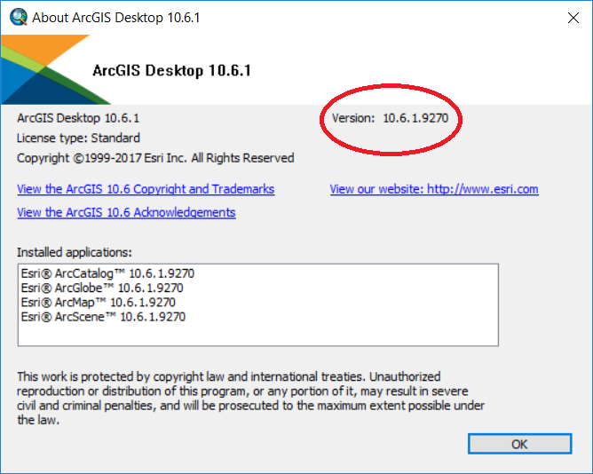
1. What is the OS of your machine?
2. What version of ArcMap are you running? From the Help menu select About ArcMap... Please see screenshot below for an example:
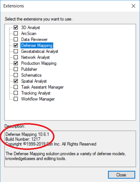
3. What is build number for Esri Defense Mapping? From the Customize menu select Extensions... and on the Extensions dialog select or highlight Defense Mapping with your cursor. Please see screenshot below:
4. Can you please zip up and attach your two FGDBs and DEM for testing.
Regards,
Dan
- Mark as New
- Bookmark
- Subscribe
- Mute
- Subscribe to RSS Feed
- Permalink
Hi Dan,
Of course:
1. Windows 7
2. ArcMap Version 10.6.0.8321
3. Defense build: 394
4. The size of one of the zipped FGDB is 124.9 MB. When I try to upload it, I get a message that it is too big. How can I get passed this?
Best regards
Malik
- Mark as New
- Bookmark
- Subscribe
- Mute
- Subscribe to RSS Feed
- Permalink
Hi Malik,
Thank you for answering my questions and for providing the two FGDBs and the DEM for testing. I can reproduce your issue with Esri Defense Mapping 10.6 Build 394.
As of today, the latest release for Esri Defense Mapping 10.6 is Patch 3 Build 920. After I install Esri Defense Mapping 10.6 Patch 3 Build 920, I cannot reproduce the issue. Can you please try installing Patch 3? Esri Defense Mapping 10.6 Patch 3 is available at
Regards,
Dan
- Mark as New
- Bookmark
- Subscribe
- Mute
- Subscribe to RSS Feed
- Permalink
Hi Dan,
Great, that sounds promising. Yes I will install Patch 3 and try it again, when my pc is done caching.
I think this will take some time, but I will reply when I have tested it.
Best Regards,
Malik
- Mark as New
- Bookmark
- Subscribe
- Mute
- Subscribe to RSS Feed
- Permalink
Hi Malik,
Sounds good. Thank you for letting me know.
Regards,
Dan
- Mark as New
- Bookmark
- Subscribe
- Mute
- Subscribe to RSS Feed
- Permalink
Hi Dan,
Installing Patch 3 fixed my problem, so now the issue is gone!
Thanks for the help and advice.
Have a great day.
Best regards
Malik
- Mark as New
- Bookmark
- Subscribe
- Mute
- Subscribe to RSS Feed
- Permalink
Hi Malik,
That is good news. Thank you for letting me know.
Regards,
Dan