- Home
- :
- All Communities
- :
- Developers
- :
- ArcGIS API Silverlight (Retired)
- :
- ArcGIS API Silverlight Questions
- :
- QueryTask result features set to wrong projection ...
- Subscribe to RSS Feed
- Mark Topic as New
- Mark Topic as Read
- Float this Topic for Current User
- Bookmark
- Subscribe
- Mute
- Printer Friendly Page
QueryTask result features set to wrong projection system
- Mark as New
- Bookmark
- Subscribe
- Mute
- Subscribe to RSS Feed
- Permalink
Hi All,
I am getting QueryTask result features in wrong projection system,
1. Task : Migrating of Arcgis server from 10.0 to 10.2.1
2. Development: Silverlight application version 5.0
3. All original map service layers render in correct location in the Map control.
4. But after the using Query task on route event layer, the result objects are set to wrong projection system, it pans to the coast of Africa near Nigeria, when i check the WKID for result features it is set to 102100.
I have also set outSpatialReference [source from map] on query result features no use,
Any one can please help on this...
Thanks
Sadanand
- Mark as New
- Bookmark
- Subscribe
- Mute
- Subscribe to RSS Feed
- Permalink
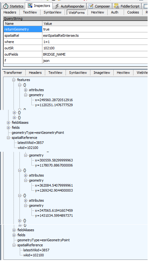
OK. Now the outSR parameter is set, unfortunately it doesn't seem to solve your issue.
Could you show us how the geometry of the returned features look like (as in Jennifer's screenshot)?
- Mark as New
- Bookmark
- Subscribe
- Mute
- Subscribe to RSS Feed
- Permalink
Hello Dominique,
I have posted the screenshot of geometry of the returned features.
- Mark as New
- Bookmark
- Subscribe
- Mute
- Subscribe to RSS Feed
- Permalink
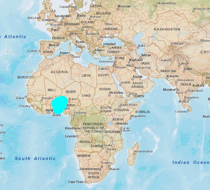
Humm, the issue doesn't seem to be at client side. The display is consistent with the returned geometry (x, y around 1000000 mean around Nigeria).
Maybe an issue at server side or an issue due to how you published the service.
If you try to display your published service in ArcMap, is it working well?
If you try to display your published service in Silverlight by using an ArcGISDynamicMapServiceLayer, is it working well?
- Mark as New
- Bookmark
- Subscribe
- Mute
- Subscribe to RSS Feed
- Permalink
Hi Dominique thanks for your replay
1. When i display my published service in ArcMap, it is working fine,
2. and when i display same service using ArcGISDynamicMapServiceLayer in Silverlight web application it is locating correctly.
3. But when i use QueryTask on this layer the result graphics locating on Africa.
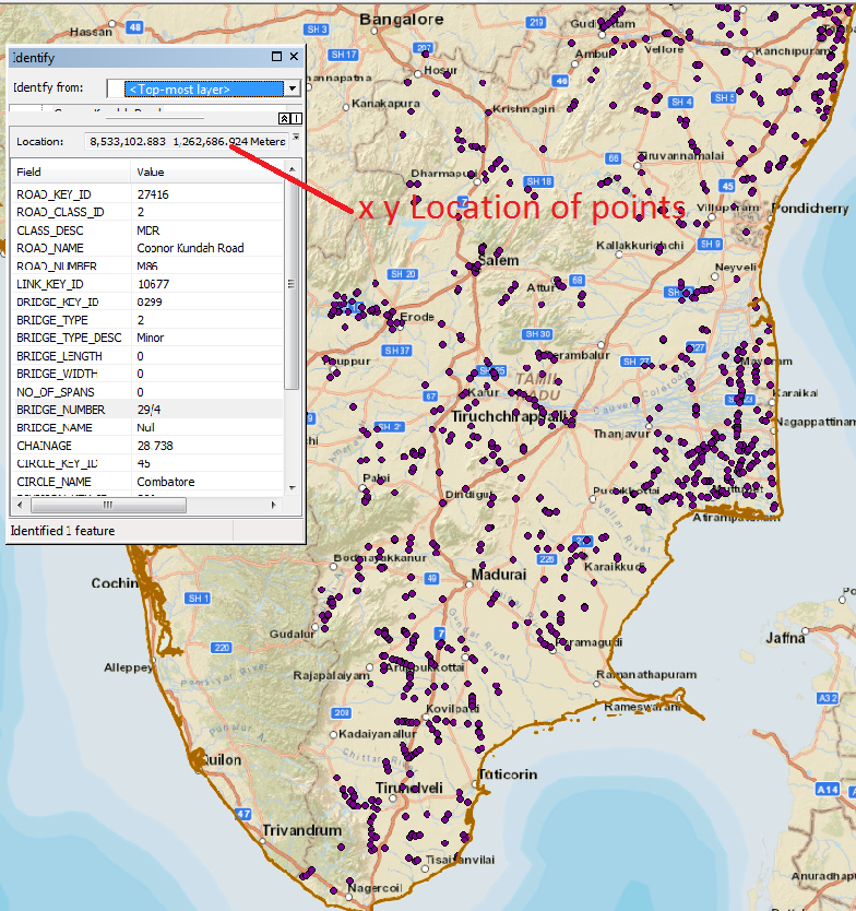
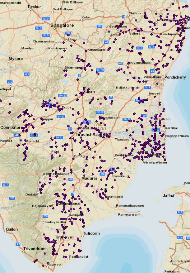
below is the screenshot of service displayed in both cases(Arcmap and ArcGISDynamicMapServiceLayer)
Please help on this issue..
Thanks
Sadanand
- Mark as New
- Bookmark
- Subscribe
- Mute
- Subscribe to RSS Feed
- Permalink
That beats me. It looks like a projection issue at server side but I don't get the reason.
I'll try to reproduce locally (I guess your service is not publicly accessible?).
As a workaround you might try publishing your service in 'WGS_1984_UTM_Zone_44N' instead of Web Mercator. May be the projection works in this case?
- Mark as New
- Bookmark
- Subscribe
- Mute
- Subscribe to RSS Feed
- Permalink
Hello
When I export metadata from arcgiscatalog I have this errors:
Error 000622: The execution failed (XslTransform) incorrect parameter
error 000840: The value does not match a file
In your opinion what's the problem.
thank you
- Mark as New
- Bookmark
- Subscribe
- Mute
- Subscribe to RSS Feed
- Permalink
But we want to use Base map or Bing map as well.
Yes services are accessible to public, below are the url of these.
1. http://119.82.100.170:6080/arcgis/rest/services/Bridge_44N/MapServer
Bridge points [Make route event layer] when using 'WGS_1984_UTM_Zone_44N' and Base map QueryTask results of this layer locating on Africa [Wrong location]
2. http://119.82.100.170:6080/arcgis/rest/services/Bridges_WM/MapServer
Bridge points [Make route event layer] when using Web Mercator projection and Base map QueryTask results of this layer locating on Africa [Wrong location]
And we have also tried on some Line features i.e. Roads with using JOIN [Joining an attribute table in ArcMap]
3. http://119.82.100.170:6080/arcgis/rest/services/Roads_WM_Join/MapServer
when using Web Mercator projection and Base map QueryTask results of this layer locating wrongly
4. http://119.82.100.170:6080/arcgis/rest/services/Roads_WM_WithoutJoin/MapServer
But when we use the same Roads without using a JOIN, QueryTask results projecting correctly.
Is there any issue when Joining an attribute table ?, My Geodatabase is in Oracle 11g version 11.2.0.1, please help..
Thanks
Sadanand
- Mark as New
- Bookmark
- Subscribe
- Mute
- Subscribe to RSS Feed
- Permalink
Hi,
Thanks for this info.
This confirms there is something wrong at server side.
The node coordinates returned by the query REST End Point are the same whatever the out spatial reference (example with WebMercator or WGS84).
Concerning the join, it's not the same issue, the coordinates returned seem good but when too much data are requested the server returns an internal error.
Not sure if these are bugs in ArcGIS server or if it's due to the way the features have been published. You might get better answers by posting the question on the server forum..
Thanks
/Dominique
- Mark as New
- Bookmark
- Subscribe
- Mute
- Subscribe to RSS Feed
- Permalink
Hi, Dominique, thanks for your support.
Sadanand
- Mark as New
- Bookmark
- Subscribe
- Mute
- Subscribe to RSS Feed
- Permalink
Was this issue ever solved? We're having the same behavior on some of our servers (ArcGIS Server 10.3.1).
Query on object id's stays in WGS84 instead of WGS84 web mercator.