
CHAPTER 4: ENGAGEMENT
Introduction
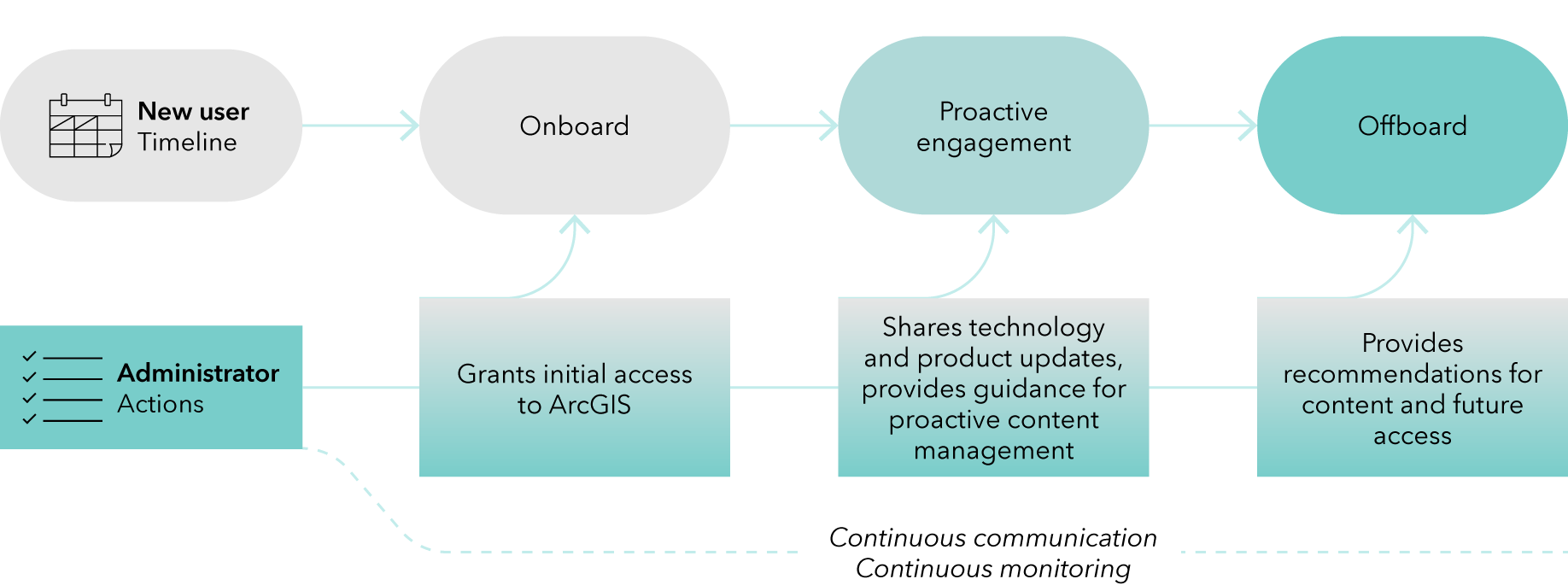
This chapter outlines steps and recommendations associated with providing continuous support and communication to GIS users across the organization. Some of this communication relates to how and where users get help as they join the institution. Some of the communication is directed to users during their tenure at the institution. And last, as users leave (for example, as students graduate and faculty or staff retire or depart the institution), it is important to provide information on various options regarding content and future access.
All throughout, continuous monitoring is integral to the governance process and serves multiple goals, such as understanding your system, raising awareness of how GIS is used, and promoting the value of geospatial technology.
Communication and monitoring practices should follow your institution’s governance standards established in Chapter 2.
Communication goals
Clear guidelines and appropriate messaging must be communicated to incoming, active, and graduating or departing students, faculty, and staff. One goal is to proactively inform users of their responsibilities by posting guidelines and policies publicly. Another goal is to allow users within your organization to be self-sufficient. Tell users how to access ArcGIS and provide them with resources to learn skills and solve problems themselves. Advise them on how to archive or dispose of unneeded content and groups. Explain their options for transferring content before leaving and what happens to their content after they leave.
All communication must comply with the institutional policies and guidelines you set.
ArcGIS access and support
Before onboarding users and communicating instructions to them, first create an ArcGIS access website. This website will provide information on how to access GIS technology, learn through training resources, and find help and technical support.
Create an ArcGIS access website
Having an internal website to explain how to access ArcGIS and get support saves time and effort for users, stakeholders, and ArcGIS administrators. The purpose of this website is to provide a one-stop shop for GIS information.
Seek to answer the following questions with your website content:
- What GIS technologies are available and to whom?
- How can a user learn more about GIS?
- How can a user get GIS support?
The website should include the following, at minimum:
- Institutional guidelines and policies related to ArcGIS
- User responsibilities
- Data retention
- Proactive content management
- A single point of contact for assistance, an outline of what kind of support and training are provided, and where to go for help
- Email address
- Support options
- Training options
- How to get started with technology and a list of available software, along with next steps of how to access it
- For ArcGIS Online, link users directly to your institution’s ArcGIS Online organization.
- For ArcGIS Pro, provide instructions on how to download and install the application.
Provide support for ArcGIS
Having an ArcGIS access website is the starting point of supporting users, but you must also provide support options to offer additional advice and answer questions they may have that are not covered by your website.
Provide internal support to GIS users
There are various organizational structures—including centralized and distributed models—that can be successful. The following are examples of how support is provided and funded:
- An IT team with a part-time or dedicated role for GIS support
- Libraries or GIS centers with a part-time or dedicated role for GIS support
- Consulting services with a part-time or dedicated role for GIS support
- Experienced GIS users across several departments
Regardless of organizational structure, ensure GIS support aligns with existing approaches at your institution. Where do users go for help with other institution-wide software offerings? Keep the following general principles in mind:
- Provide a single point of contact for users to find the support they need. If user requests need to be assigned to another support team, the point of contact can help the user find the next steps and appropriate resources.
- Specify options and pathways to get help. Depending on your institutional standards, you may provide an email address, a web form, a ticket system, a phone number, a Slack channel, or another contact method.
Set clear expectations and boundaries with your users, including the support staff’s typical response time and institutional policies about support inquiries.
Use Esri Support for GIS inquiries
If your GIS support staff cannot support inquiries, Esri Support is an option. As part of your Education Institution Agreement, or a Departmental Agreement, you can designate Esri authorized support callers who are on your GIS support staff or are consistent and experienced ArcGIS users. The number of authorized support callers varies depending on the type of agreement.
Set expectations and boundaries with your users, such as the following:
- Prepare by gathering information to include when placing an Esri Support ticket (such as the operating system, software, and description of the issue) and tell users how this information is collected.
- Communicate the response time to place an Esri Support ticket.
As an authorized support caller, you can elevate the user to be the main contact for a technical support case. You can still monitor cases and their solutions.
Provide training and documentation to GIS users
You can provide training resources that you create, that Esri Training has made available, or that are recommended by the Esri Community.
Ensure training content you share with your users is updated and relevant. If you include screenshots, budget time and resources to keep them up to date. Maintain a database of documentation to track what to review when a new product version is released. As a GIS support staff, find a balance between creating and maintaining resources and using existing resources provided by Esri or your institution.
Communication approaches
There are several considerations to keep in mind when communicating with users:
- Intended audience
- Everyone—Instructions to access ArcGIS, existing policies and guidelines, ways to get help, resources for support and training, and so on
- A subset of users—What do during offboarding (such as a specific guide for graduating students), updates to specific products only used by a subset of users, and so on
- Timeline and urgency
- Critical—Information related to a major update, product retirements, student offboarding prior to graduation, and so on
- Routine—Information such as reminders of institutional policies, what to do proactively with content during tenure at the institution, and so on
- Purpose
- Prompt action—Requests to delete or find alternative storage methods for large items, reminders to use metadata, and so on
- Provide information—Available support and training options, upcoming updates, product retirement, and so on
Use a variety of communication channels, depending on your institutional policies and preferences:
- ArcGIS capabilities, bulk emails, or your institution’s internal channels
- Use the ArcGIS Online information banner and access notice mechanisms during critical time periods (prior to graduation, for example, or after a major update).
- Send periodic reminder bulk emails, following institutional governance, about managing content. Collaborate with IT colleagues to use your institutional bulk email solutions.
- Use your institutional preferred communication methods, such as Slack, Microsoft Teams, or internal messaging apps.
- GEO Jobe email capabilities to communicate with users or a subset of users
- Scripting
- Collaborate with IT colleagues to identify whether users are authorized and to identify a subset of users, groups, or content that meet a set of criteria for which you want to target a specific message.
- Collaborate with IT colleagues to use scripting and ArcGIS APIs to send email notifications, in compliance with your specific institution bulk email procedures and solutions.
The following sections provide examples of communication during onboarding, ongoing and active, and offboarding periods.
Onboarding
The goal of onboarding is to allow users access to ArcGIS, set expectations for reasonable and appropriate use, and supply next steps to learn more. It is important to do this in an automated, scalable manner. Do the following for new users:
- Provide information about how to access ArcGIS.
- For institution members, set up SAML logins and new member defaults.
- For external collaborators, consult your institution’s policies and terminology for affiliates. While it’s possible to use an ArcGIS login, it is recommended that you provide a SAML login as it is a scalable workflow and puts responsibility in the correct hands, without requiring a GIS administrator to monitor or remove access at the end of the project.
- Provide information about how to get help, support, and training by linking to your ArcGIS access website.
Ongoing and active communication
Communication with users throughout their tenure at the institution is important. Sharing product updates and new capabilities, as well as product retirements, is key to uninterrupted use. In addition, you can train users to manage their own content.
Note: When new capabilities are added to ArcGIS, review and add appropriate privileges to users' roles.
Users taking actions proactively, throughout their tenure at the institution, can help manage storage space, reduce the amount of content that is accumulated in ArcGIS Online, and improve curated data and app experiences.
Communicate content management guidelines with users consistently as part of your institution’s data governance strategy. At least once per semester, as per the governance strategy you have established, communicate with users on the following topics:
- Clarify expectations of users who are part of collaborations (for example, research projects or course group projects), including responsible content ownership, what happens to this content once a collaborator leaves (such as graduation), and who manages the content if the collaboration comes to an end.
- Provide guidance on proper metadata, including established tags to flag important content.
- Delete inactive content (for example, test items or old work).
- Provide suggestions for data management in a system that has a finite amount of storage. Keep only relevant versions of datasets or move old versions of the data outside the system.
- Share the Delete items help documentation, which includes considerations and tips to know before you delete content.
- Train students to properly dispose of their content prior to graduation (for example, how to transfer their work, how to delete unneeded items, and the timeline for doing so).
- Explain how to seek assistance from administrators to store large items.
- You can set alert options so that the owner of any item larger than a certain threshold (for example, 100 MB) will receive a message from the administrators.
- In certain instances, you can make exceptions to policies (such as your institution’s per-user feature storage limit) if there is an established process, including documentation of how an exception is handled and the responsibilities tied to it.
- Consider various options to increase storage capacity.
- Ask GIS instructors to make content management part of their syllabus.
- Consider placing excerpts in course syllabi or assignments. This could be a learning opportunity to understand cloud storage, various content management models, credits, and costs, especially since once students are employed in GIS roles across various industries, they will need to understand these business models. In the private and public sectors, the availability of licenses and credits is much more restricted than in education.
- Dispose of unused groups and share the Manage groups documentation.
Offboarding
As users prepare to depart the institution, it is important that you provide guidelines on what they need to do before they leave and what will happen after they leave, specifically about what happens with their account and content.
- Proactively inform users of their responsibilities. For example, they need to dispose of their groups and content before they leave.
- Post policies and guidelines publicly.
- Send periodic reminder emails, referring to policies and guidelines.
- Allow users to change ownership of their content or transfer their training history.
- Give users a custom role with privileges that allow them to change ownership of their content and groups. This can be set as part of the new member defaults.
- A user can request Esri's assistance in transferring their training history in Esri Academy to a different account (for example, a public account). See Managing Enterprise-wide Access to Esri E-Learning.
Communicate account information and data retention guidelines with users consistently as part of your institution’s data governance strategy.
Communication about offboarding should happen prior to the end of each semester, at least two or three times per year, to allow ample time for users to take action. Provide guidance on the following:
- How long will they be able to access ArcGIS
- How to transfer ownership of items within the organization
- How to transfer ownership outside of organization
- What will happen to their content if they do not take any actions
- How collaborators in a group can proactively work with users who are leaving to transfer ownership of group content to a remaining member
Review Messaging for ArcGIS Online users leaving the university (students, faculty, staff) to share similar communication.
Continuous monitoring and organizational transparency
When you establish processes and procedures for monitoring ArcGIS use, ensure compliance with organizational transparency. This information may be important to the larger university community, including many stakeholders who don’t have administrator access to the organization to see internal reporting structures like the administrator dashboard and reports. As you collect this information about your organization’s health, you can share it with stakeholders for transparency and informed decision making.
Monitor usage
There are multiple ways to monitor usage, each adding additional capabilities and levels of complexity.
Use ArcGIS Dashboards with no customization.
You can use the ArcGIS status dashboard to understand and monitor how ArcGIS Online is used. The dashboard is organized into five sections: Credits, Content, Apps, Members, and Groups. There is no scripting or customization required to use the ArcGIS status dashboard.
Learn more about dashboards in View and report status.
Customize the Admin Insights Template.
The Admin Insights Template is built using ArcGIS Notebooks and ArcGIS Dashboards. It provides insights about an institution's users, content, and groups. It is composed of three dashboards, which are snapshots of your organization’s information:
- Users and Licenses—The Users and Licenses dashboard provides visibility into how an ArcGIS organization’s users are structured and how they are being used over time. You can identify inactive or underused accounts, validate licenses, and spot trends that may signal the need to adjust onboarding processes, licensing strategy, or user management policies.
- Content—The Content dashboard helps you understand what content exists across the organization and how it is being used. It highlights stale or unused items, supports validation of sharing and metadata standards, and tracks the growth of non‑authoritative content. You can also monitor high‑impact items (publicly shared, highly viewed, or large content) and explore upstream and downstream content dependencies.
- Groups—The Groups dashboard provides insight into how groups are being used to organize content and manage access across the organization. It helps identify groups that support critical sharing workflows, surface unused or low‑value groups (such as empty or single‑member groups), and validate that group sharing settings align with organizational access and collaboration policies.
The Admin Insights Template is a two-step deployment, and scripting is part of the deployment process. One notebook creates all of the items in the ArcGIS Online organization that are necessary for the toolkit (a data table, the three dashboards, and an ArcGIS Experience Builder app), and the second notebook populates the content with the organization's information.
Build a custom usage dashboard
For additional transparency to your university community, you can build a usage dashboard and integrate information from external institutional systems, such as a user's degree programs or majors.
A customized dashboard allows for clearer visualization of named users and apps. When integrated with other institutional systems of record, the dashboard can provide additional information on usage across majors, degree programs, affiliation, and so on, which go beyond what ArcGIS Dashboards and the Admin Insights Template could provide.
Refer to the GIS for Everyone (...and how to build your own ArcGIS Dashboard to show it!) blog article by a user from the University of Michigan, which uses a Jupyter notebook as a starting point. An alternative approach is shared by Claremont Colleges.
Start collecting data as soon as possible to develop a historical record that can help with predicting future growth trends.
Dashboard examples
The following links are examples of how institutions have implemented their own customized dashboards to show the growing impact of ArcGIS across their respective communities and integrate information from other institutional systems.
Conclusion
The recommendations in this chapter can help you understand various options for providing continuous support and communication to users across the organization. Continuous monitoring of ArcGIS is also important to assess trends and needs, as well as plan for the future. All of these actions should align with governance policies that you have put in place for managing ArcGIS.
Next Steps
Read the rest of the chapters:
E-book PDF will be available soon.
Contact your Account Manager or highered@esri.com with any questions.
