- Home
- :
- All Communities
- :
- Products
- :
- ArcGIS Spatial Analyst
- :
- ArcGIS Spatial Analyst Questions
- :
- Can I use Cost Distance tools to model travel time...
- Subscribe to RSS Feed
- Mark Topic as New
- Mark Topic as Read
- Float this Topic for Current User
- Bookmark
- Subscribe
- Mute
- Printer Friendly Page
Can I use Cost Distance tools to model travel times?
- Mark as New
- Bookmark
- Subscribe
- Mute
- Subscribe to RSS Feed
- Permalink
I am working with the Cost Distance tool and the numbers I am getting are the product of cost and distance (six/seven digit numbers, as my cell size is 5000 feet, my weights are 0-11). I have set up costs to be in minutes to cross a cell and want to make a map of my study area with distance to reach one of my sources. However, the cost distance output seems to be distances (very large numbers) not costs. If I run the Cost Path tool, and sum up the costs of the cells along my cost path with Zonal Statistics, I get the total I expect in minutes (in the case below 45.0 to travel 25 miles or so).
This page in the help seems to imply this can be done, note the picture of total costs to transport lumber.
Calculating cost of travel—ArcGIS Help | ArcGIS Desktop
Is there a way to do this in Spatial Analyst? I want to do this in raster because I want to model accessibility (in minutes) of all cells in my study area, including those that are away from roads.
- Mark as New
- Bookmark
- Subscribe
- Mute
- Subscribe to RSS Feed
- Permalink
Curtis... 'costs' are a relative term. In your case ascribing minutes to cross a cell is reasonable and allows you to model traversing open landscapes more readily. For your roads, you could translate speed limit to a travel time, hence modelling various road types. Similarly, landscapes like open field, hardwood forest etc can be ascribed a representative cost which would obviously be slower. I do this during the cost surface construction phase. For non-motor transit, path distance allows you to incorporate slope characteristics more representative of walking/hiking speed differences associated with terrain.
In your case, if you are travelling just along roads by vehicle, you can simply set your non-road cells to nodata and you will get similar results to a simple network analyst Orig-Dest study
- Mark as New
- Bookmark
- Subscribe
- Mute
- Subscribe to RSS Feed
- Permalink
> For your roads, you could translate speed limit to a travel time, hence modelling various road types.
I did this -- I converted each cell to cost in minutes to cross a cell (cell width (length) / speed (length/time).
But the cost distance raster I get has numbers in six figures, as if I am getting a weighted sum of distance x cost, not just cumulative cost. (cell size is 5000 feet). I think my cost numbers are right because the zonalsum of my cost path gives me 45.0 minutes. What am I doing wrong?
- Mark as New
- Bookmark
- Subscribe
- Mute
- Subscribe to RSS Feed
- Permalink
it would be the cumulative cost... if you have 3 cells side-by-each (as we say in Canada), and it takes 5 seconds per unit, then the cumulative cost at cell 3 is 15 times the number of units per cell
I think in your case you have cost per unit distance, hence your weighted cost... The cost path, if it is correct, then you have done something right.
If you are getting issues, then simply do a cell inspection of the cumulative surface along the cost path. Don't forget everything is 'relative' so if you are out by a constant factor, it won't affect the result.... try it
- Mark as New
- Bookmark
- Subscribe
- Mute
- Subscribe to RSS Feed
- Permalink
Thanks again for your thoughts, Dan. I took this to some of my Esri friends from the Spatial Analyst team at Esri UC and they had the answer for me right away: when you are calculating costs, you need to calculate the cost per map unit, not per cell. In retrospect this makes a lot of sense as the result is not dependent on cell size!
In my case I came up with the following equation to convert miles per hour travel time (on vector data like roads) to cost in minutes per foot (ie map units, I'm in state plane):
# conv factor: 60 min/hr / 5280 ft/mi = .00136 min-mi / ft-hr
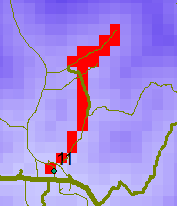
# cost = .00136 min-mi/ft-hr / xx mi-hr = yy min/ftMy results now look like what I was looking for with travel time in minutes on my map (I assigned a slow mph to overland travel cells):
- Mark as New
- Bookmark
- Subscribe
- Mute
- Subscribe to RSS Feed
- Permalink
makes sense... my cell size are usually 1 meter and I tend to use relative scaling parameters.
So it is essential to consider the scaling that needs to be considered if you are using absolute valued parameters rather than relative (ie it takes twice as long to traverse a 30mph road than a 60 mph road)