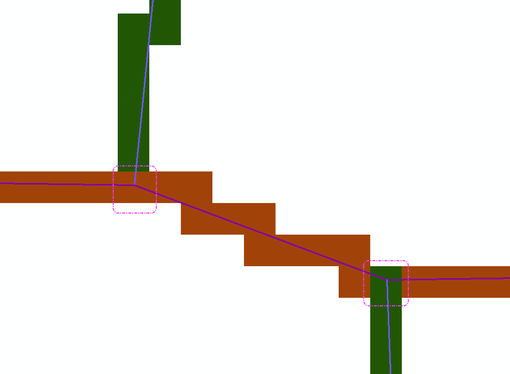
Hi, I have a road feature class. I want to change the vector lines to raster values. Is there any easy way to specify cell value by preference at junctions?. For example, Road type A with Road B at a T junction. Some times it chooses to make the cell Road Value A some time Road Value B. Two junctions below. Western junction takes value of Brown. The Eastern junction takes value of Green. For my use I want the cell to always take A value at junctions of A/B .
I am using Arcmap 10.6.1. Raster cell size is 1m.
Dear Jim,
Tried to run the costpath tool with 4 destinations and a completely different data set. Using same steps, but result is an error message as attached to original message. It seems to freeze up for about 6 to 15 mins and then return an error message about memory.
Our machines are Dell Precision 5910
Cheers
Jeff
Okay please find attached a file geodatabase containing:
Hovercraft_base [single point vector feature - origin]
Travel_points [point vector feature with two points - destination]
Cost_surface_water [raster layer with two conditions - 1 or 3 [impedance layer]
Step 1: Run Cost Path to produce Cost surface from point of origin, and corresponding backlink
Step 2: Run Cost Path or Cost Path as Polyline
Input Raster or feature destination: Travel Points [no selection of points or both points selected]
Input cost distance raster: CostDist [product of Step1]
Input cost backlink raster: Cost_surface_water_blk [product of Step1]
Output Raster: CostPath
Path Type: Each_Cell
Set Environment Processing Extent to same as Cost_surface_water
Ok Environment settings
Ok to Cost Path Settings
Okay now it ran for raster output to both points [the other day neither worked so unsure why it worked today].
Repeat the same process for Cost_path to Poly and it produces only one line to second point in destination file.
Can not figure how to add file to this message so added to original.
Jeff Chartrand
HI Jeff
can you post data and precise steps to repro please?
You're correct: If you're using cost distance for more than just barriers, you can't switch to euc dist + barriers. At ArcGIS Pro 2.5, you can consider switching to Distance Accumulation.
Regards,
-jt
We are still on 10.6.1 for next month or two at least. Then moving to 10.7.1.
I assume that the geometry is correct as it will work if I use a single destination or if I use a single destination selected in a feature file. The files are all in gdb so the geometry is being updated with any changes. My understanding is that Euclidean distance with barriers works with a homogeneous surface not with a heterogeneous impedance or friction surface. My cost surface treats each cell to a impedance or friction value.
This layer is being done in Projected coordinates British National Grid using OSGB36 and is in metres.
Hi Jeff
Are you still seeing this behavior at 10.7?
Can you confirm that you constructed your accumulative cost surface using as source the geometry in the upper right of your screenshot?
This thread may be helpful. In short, I recommend switching workflows like yours to using euclidean distance with barriers.
-Jim TenBrink
サインインしたメンバーは投稿、更新のフォローなどができます。初めてですか?無料アカウントを登録してください。
Find useful guides, FAQs, and documents to help you navigate and make the most of Esri Community.