- Home
- :
- All Communities
- :
- Products
- :
- Oriented Imagery
- :
- Oriented Imagery Questions
- :
- Oriented Imagery Viewer 'Direction' issue
- Subscribe to RSS Feed
- Mark Topic as New
- Mark Topic as Read
- Float this Topic for Current User
- Bookmark
- Subscribe
- Mute
- Printer Friendly Page
Oriented Imagery Viewer 'Direction' issue
- Mark as New
- Bookmark
- Subscribe
- Mute
- Subscribe to RSS Feed
- Permalink
- Report Inappropriate Content
Good Afternoon,
I've been doing some testing with the new Oriented Imagery capabilities in AGOL, but I have only managed to upload one test set of data properly. My last couple of attempts have ended up with maps where the OI field-of-view cone points in the opposite direction of the actual view of the photo (pictured below). If this is working as intended, I wonder if some sort of offset can be added to the dataset to better pair the aerial and 360 imagery.
Is there a best practice for adding images to the OIC dataset? I've attempted using a .txt file with the image paths and making a feature layer that follows the OIC table schema. My one successful Oriented Imagery Viewer map was created using the .txt method, but that test was also with a much smaller dataset.
Any information would be a great help and thanks in advance!
- Mark as New
- Bookmark
- Subscribe
- Mute
- Subscribe to RSS Feed
- Permalink
- Report Inappropriate Content
@Jaire_McNichols here are 360° Experience Builder widget options that can easily correct image direction. These 360° photo and video solution seamlessly integrates imagery into ArcGIS , offering effortless usability and unmatched workflow customization. The tools facilitate the swift deployment of large-scale 360° imagery projects within hours of collection, with the added advantage of storing video in YouTube or AWS for seamless access via ArcGIS:
https://www.nodeology.net/site-viewer-360-for-arcgis/

https://www.nodeology.net/vidgeo-for-arcgis/

- Mark as New
- Bookmark
- Subscribe
- Mute
- Subscribe to RSS Feed
- Permalink
- Report Inappropriate Content
Hi Clark,
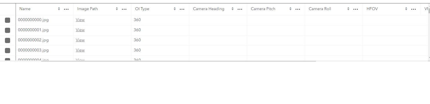
It seems to me that you are working with Oriented Imagery Catalogs. Can you also tell me how you added these images. Is it using a FrameTable, or Image list. It seems like you too do not have any heading info defined. If you are using Oriented Imagery catalogs, You can try the calculate heading tool in the Oriented Imagery Management tools. From the pictures I see above you seem to have sequential data so the tool might actually help. You might have to adjust the parameters so it works with your dataset.
Thanks,
Randall
- Mark as New
- Bookmark
- Subscribe
- Mute
- Subscribe to RSS Feed
- Permalink
- Report Inappropriate Content
Hi Jaire_McNichols,
I had a look at the OIV issuetable.jpg that you have put up here. So it looks like there is no heading defined. If you have a look at the properties of the Oriented Imagery dataset layer in ArcGIS Pro, under the oriented imagery tab there will be a Camera Heading default value. It might just be undefined.
If you added these images using a text file, then its basically read the EXIF data within the image and used the GPS information from there to get the position. However it seems it does not have a heading info. Do you know the source of these images? What camera was used. Can you send me a couple of image so I can try it out.
Thanks
Randall
- Mark as New
- Bookmark
- Subscribe
- Mute
- Subscribe to RSS Feed
- Permalink
- Report Inappropriate Content
Thanks for the reply Randall,
The source images contains sensitive information, so I can't share much of it at present. I did read the EXIF data of one of the images using freeware called 'exiftool', and 'Pose Heading Degrees' seems to be the Heading field that I want applied to the 'Camera Heading' field in my OIC. Is there any way that I can get the Oriented Imagery Toolbox to 'detect' this specific metadata field? I would prefer to add images through a text file with a list of image paths, but I worry that this method will not be able to connect the 'Pose Heading Degrees' to 'Camera Heading'
