Turn on suggestions
Auto-suggest helps you quickly narrow down your search results by suggesting possible matches as you type.
Cancel
- Home
- :
- All Communities
- :
- Services
- :
- Esri Technical Support
- :
- Esri Technical Support Blog
- :
- GeoMentoring - Support Services goes to CC Griffin...
GeoMentoring - Support Services goes to CC Griffin Middle School for GIS Day
Subscribe
449
0
01-18-2013 03:23 AM
- Subscribe to RSS Feed
- Mark as New
- Mark as Read
- Bookmark
- Subscribe
- Printer Friendly Page
- Report Inappropriate Content
01-18-2013
03:23 AM
The Esri Support Services department piloted its own GeoMentoring program in 2009 to help increase geographic awareness and geoliteracy, and has been participating each year in local schools. The eighth grade science classes at a middle school in Concord, North Carolina were identified as an ideal site for GeoMentoring, as they have a strong technology focus. In November 2012, to help celebrate GIS Day, a variety of team members from the Esri East Coast Support Center in Charlotte, NC participated as GeoMentors in our latest school visit.
The GeoMentoring activities took place over the span of three days where Esri Support staff worked with 110 middle school students. The three day event included a combination of lecture materials on GIS, a field geocaching activity, an interactive exercise, and a lab component utilizing core ArcGIS software. Lecture content included discussions on geography, GIS, and the history and many uses of the technology as an aid in everyday decision making and planning.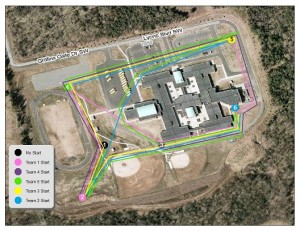
The first day was a bit colder than some had anticipated as we made our way outside for our field activities in geocaching. Students were given GPS devices after a quick crash course in usage from their mentors and sent out to roam the school campus to traverse between waypoints. This was a fun way to incorporate GIS into an activity they could learn from including geographic concepts of cardinal direction, distance, and spatial awareness. Rounding up 110 middle schoolers proved challenging as some had ideas of running between waypoints to keep warm! Each waypoint or cache included a container with a geography question, which provided students an opportunity to collaborate with teammates in answering these geographic questions.
Students really enjoyed and took hold of this activity, using their creativity to develop unique maps with a wide array of colors and symbolization for waypoints and GPS tracks. Everything from caution cones to skull and cross bones were used!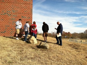
Throughout these three days in working with the teams, the students took the opportunity to ask questions, and were very interactive in sharing their existing knowledge on geography. Support Services plans on continuing the GeoMentoring program as this gives Esri team members additional opportunities to interact with GIS outside of the office, and it gives local schools exposure to geography and the ability to learn what GIS is and how it can relate to their everyday life.Melissa Jarman - Geodata Support Analyst
The GeoMentoring activities took place over the span of three days where Esri Support staff worked with 110 middle school students. The three day event included a combination of lecture materials on GIS, a field geocaching activity, an interactive exercise, and a lab component utilizing core ArcGIS software. Lecture content included discussions on geography, GIS, and the history and many uses of the technology as an aid in everyday decision making and planning.

A map of the GPS tracks that students
made during the geocaching field activity.
A map of the GPS tracks that students
made during the geocaching field activity.
The first day was a bit colder than some had anticipated as we made our way outside for our field activities in geocaching. Students were given GPS devices after a quick crash course in usage from their mentors and sent out to roam the school campus to traverse between waypoints. This was a fun way to incorporate GIS into an activity they could learn from including geographic concepts of cardinal direction, distance, and spatial awareness. Rounding up 110 middle schoolers proved challenging as some had ideas of running between waypoints to keep warm! Each waypoint or cache included a container with a geography question, which provided students an opportunity to collaborate with teammates in answering these geographic questions.
Students participated in an interactive river dam activity as well as lab exercises. These two exercises helped to understand and discuss how GIS is used to guide and make educated planning decisions. The lab exercises consisted of students importing the GPS tracks, using basic GIS functions such as overlaying and symbolizing, and interacting with standard tools within ArcMap.
Students really enjoyed and took hold of this activity, using their creativity to develop unique maps with a wide array of colors and symbolization for waypoints and GPS tracks. Everything from caution cones to skull and cross bones were used!

A group of students locating a cache
during their outside geocaching activity.
Throughout these three days in working with the teams, the students took the opportunity to ask questions, and were very interactive in sharing their existing knowledge on geography. Support Services plans on continuing the GeoMentoring program as this gives Esri team members additional opportunities to interact with GIS outside of the office, and it gives local schools exposure to geography and the ability to learn what GIS is and how it can relate to their everyday life.Melissa Jarman - Geodata Support Analyst
Labels
You must be a registered user to add a comment. If you've already registered, sign in. Otherwise, register and sign in.
Labels
-
Announcements
70 -
ArcGIS Desktop
87 -
ArcGIS Enterprise
43 -
ArcGIS Mobile
7 -
ArcGIS Online
22 -
ArcGIS Pro
14 -
ArcPad
4 -
ArcSDE
16 -
CityEngine
9 -
Geodatabase
25 -
High Priority
9 -
Location Analytics
4 -
People
3 -
Raster
17 -
SDK
29 -
Support
3 -
Support.Esri.com
60
- « Previous
- Next »