- Home
- :
- All Communities
- :
- Industries
- :
- Education
- :
- Education Blog
- :
- Another reason to migrate to the ArcGIS Online New...
Another reason to migrate to the ArcGIS Online New Map Viewer: Popups
- Subscribe to RSS Feed
- Mark as New
- Mark as Read
- Bookmark
- Subscribe
- Printer Friendly Page
- Report Inappropriate Content
The new ArcGIS Online map viewer, which debuted in early 2021, contains many enhancements that instructors, researchers, students, and others are finding incredibly useful. One advantage the new viewer has over what is now known as the "classic viewer" is improved popup imagery functionality.
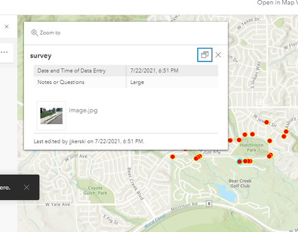
Consider the popup size in one of my vegetation surveys as mapped in ArcGIS Online classic viewer, below. While you can click on the image and pull it up as a larger size in a separate browser tab, the image in the map popup is rather small.
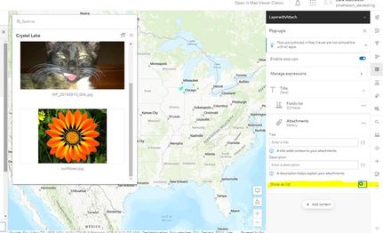
In the new map viewer, you can make the popup larger. To do this, change the "show as list" from the list list mode to gallery mode as shown below. The gallery mode makes the images much larger. Plus, you can dock or undock the popups in the new map viewer for additional flexibility.
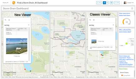
Equally wonderful is that apps that are based on the new map viewer also take advantage of this and other new capabilities. These include story maps, dashboards, and more. See my example below that shows the side-by-side comparison of a dashboard I built for a storm drains education project with the new viewer (left side) vs the classic viewer (right side).
This may seem like a small enhancement, but was a desire voiced by many educators over the years. The message is: Keep those suggestions coming! Our education team is in continued close communication with our product developers and other tools and we relay these suggestions directly to them.
--Joseph Kerski
You must be a registered user to add a comment. If you've already registered, sign in. Otherwise, register and sign in.
-
Administration
39 -
Announcements
45 -
Career & Tech Ed
1 -
Curriculum-Learning Resources
180 -
Education Facilities
24 -
Events
47 -
GeoInquiries
1 -
Higher Education
520 -
Informal Education
266 -
Licensing Best Practices
47 -
National Geographic MapMaker
17 -
Pedagogy and Education Theory
187 -
Schools (K - 12)
282 -
Schools (K-12)
185 -
Spatial data
24 -
STEM
3 -
Students - Higher Education
232 -
Students - K-12 Schools
86 -
Success Stories
22 -
TeacherDesk
1 -
Tech Tips
83
- « Previous
- Next »


