Turn on suggestions
Auto-suggest helps you quickly narrow down your search results by suggesting possible matches as you type.
Cancel
- Home
- :
- All Communities
- :
- Industries
- :
- Education
- :
- Education Blog
- :
- Analyzing Supermarket Access with ArcGIS Online
Analyzing Supermarket Access with ArcGIS Online
Subscribe
933
0
07-18-2013 10:55 PM
- Subscribe to RSS Feed
- Mark as New
- Mark as Read
- Bookmark
- Subscribe
- Printer Friendly Page
- Report Inappropriate Content
07-18-2013
10:55 PM
I recently created a set of activities based on using web-based GIS tools to teach spatial thinking using drive-time buffers, a set of activities that use viewsheds as a teaching tool, another on the use of zonal statistics, another on analyzing the best route to a facility, and another on routing around barriers. They are all free, easy to use, powerful, based on Esri technology, and they foster spatial thinking.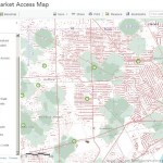
Now let's open this map that incorporates point, line, and polygon data and some of the spatial analysis techniques.... This map shows access to supermarkets. The supermarkets have been buffered for walking (1 mile) and driving (10 minutes). People in poverty with low access and farmers markets are also shown. Notice how the symbology changes as you zoom out of Detroit to the county level. Find, zoom to, and study your own community and compare it to Detroit. What is the purpose of this map that you have been examining? Why is access to supermarkets a concern to society? What are the patterns of access in your own community, or the neighborhoods across town?
Turn on the map layer indicating food expenditures at home versus away from home. Examine the details for this map layer so you will understand what it means.
How have the spatial analysis techniques you have been exploring using the maps above been used to create this map? What about the map's symbology do you find interesting, useful, or even confusing? Why? How could you use this map as a teaching and learning tool?

Analyzing supermarket access in ArcGIS Online.
Now let's open this map that incorporates point, line, and polygon data and some of the spatial analysis techniques.... This map shows access to supermarkets. The supermarkets have been buffered for walking (1 mile) and driving (10 minutes). People in poverty with low access and farmers markets are also shown. Notice how the symbology changes as you zoom out of Detroit to the county level. Find, zoom to, and study your own community and compare it to Detroit. What is the purpose of this map that you have been examining? Why is access to supermarkets a concern to society? What are the patterns of access in your own community, or the neighborhoods across town?
Turn on the map layer indicating food expenditures at home versus away from home. Examine the details for this map layer so you will understand what it means.
How have the spatial analysis techniques you have been exploring using the maps above been used to create this map? What about the map's symbology do you find interesting, useful, or even confusing? Why? How could you use this map as a teaching and learning tool?
You must be a registered user to add a comment. If you've already registered, sign in. Otherwise, register and sign in.
About the Author
I believe that spatial thinking can transform education and society through the application of Geographic Information Systems for instruction, research, administration, and policy.
I hold 3 degrees in Geography, have served at NOAA, the US Census Bureau, and USGS as a cartographer and geographer, and teach a variety of F2F (Face to Face) (including T3G) and online courses. I have authored a variety of books and textbooks about the environment, STEM, GIS, and education. These include "Interpreting Our World", "Essentials of the Environment", "Tribal GIS", "The GIS Guide to Public Domain Data", "International Perspectives on Teaching and Learning with GIS In Secondary Education", "Spatial Mathematics" and others. I write for 2 blogs, 2 monthly podcasts, and a variety of journals, and have created over 5,000 videos on the Our Earth YouTube channel.
Yet, as time passes, the more I realize my own limitations and that this is a lifelong learning endeavor and thus I actively seek mentors and collaborators.
Labels
-
Administration
39 -
Announcements
45 -
Career & Tech Ed
1 -
Curriculum-Learning Resources
180 -
Education Facilities
24 -
Events
47 -
GeoInquiries
1 -
Higher Education
520 -
Informal Education
266 -
Licensing Best Practices
47 -
National Geographic MapMaker
17 -
Pedagogy and Education Theory
187 -
Schools (K - 12)
282 -
Schools (K-12)
185 -
Spatial data
24 -
STEM
3 -
Students - Higher Education
232 -
Students - K-12 Schools
86 -
Success Stories
22 -
TeacherDesk
1 -
Tech Tips
83
- « Previous
- Next »